Guavio Formation
The Guavio Formation (Spanish: Calizas del Guavio, Kicg) is a geological formation of the Altiplano Cundiboyacense, Eastern Ranges of the Colombian Andes. The formation consists of conglomerates, shales and limestones, dates to the Late Jurassic and Early Cretaceous periods; Tithonian to Berriasian epochs and has a maximum thickness of 1,000 metres (3,300 ft).
| Guavio Formation Stratigraphic range: Tithonian-Berriasian ~150–140 Ma | |
|---|---|
| Type | Geological formation |
| Unit of | Cáqueza Group |
| Sub-units | Caliza de Las Mercedes Mb. Lutitas de Las Mercedes Mb. Caliza de Malacara Mb. Lutitas de Miralindo Mb. Conglomerado de Miralindo |
| Underlies | Macanal Formation |
| Overlies | Batá Fm., Girón Fm |
| Thickness | up to 1,000 m (3,300 ft) |
| Lithology | |
| Primary | Conglomerate |
| Other | Limestone, shale |
| Location | |
| Coordinates | 4°59′34.1″N 73°28′53.8″W |
| Region | Altiplano Cundiboyacense Eastern Ranges, Andes |
| Country | |
| Type section | |
| Named for | Guavio River |
| Named by | Rodríguez & Ulloa |
| Location | Alto de Miralindo, Guateque |
| Year defined | 1976 |
| Coordinates | 4°59′34.1″N 73°28′53.8″W |
| Region | Cundinamarca, Boyacá |
| Country | |
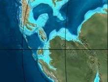 Paleogeography of Northern South America 150 Ma, by Ron Blakey | |
Etymology
The formation was defined and named in 1976 by Rodríguez and Ulloa after the Guavio River, Cundinamarca.[1]
Description
Lithologies
The Guavio Formation has a maximum thickness of 1,000 metres (3,300 ft), and is characterised by a sequence of conglomerates, shales and limestones.[1]
Stratigraphy and depositional environment
The Guavio Formation, the lowermost unit of the Cáqueza Group, overlies the Batá Formation and is overlain by the Macanal Formation. The unit is subdivided into five members, from old to younger; Conglomerado de Miralindo, Lutitas de Miralindo, Caliza de Malacara, Lutitas de Las Mercedes and Caliza de Las Mercedes. The age has been estimated to be Tithonian to Berriasian, spanning the Jurassic-Cretaceous boundary. Stratigraphically, the formation is time equivalent with the Arcabuco Formation. The formation has been deposited in a shallow marine environment in an oxygen-poor basin.[1]
Outcrops
The Guavio Formation is apart from its type locality at the Alto de Miralindo and Cuchilla de Manizales, found near Gachalá and Medina.[1]
Regional correlations
| Age | Paleomap | VMM | Guaduas-Vélez | W Emerald Belt | Villeta anticlinal | Chiquinquirá- Arcabuco | Tunja- Duitama | Altiplano Cundiboyacense | El Cocuy | ||||
|---|---|---|---|---|---|---|---|---|---|---|---|---|---|
| Maastrichtian |  | Umir | Córdoba | Seca | eroded | Guaduas | Colón-Mito Juan | ||||||
| Umir | Guadalupe | ||||||||||||
| Campanian | Córdoba | ||||||||||||
| Oliní | |||||||||||||
| Santonian | La Luna | Cimarrona - La Tabla | La Luna | ||||||||||
| Coniacian | Oliní | Conejo | Chipaque | ||||||||||
Güagüaquí | Loma Gorda | undefined | La Frontera | ||||||||||
| Turonian |  | Hondita | La Frontera | Otanche | |||||||||
| Cenomanian | Simití | hiatus | La Corona | Simijaca | Capacho | ||||||||
| Pacho Fm. | Hiló - Pacho | Churuvita | Une | Aguardiente | |||||||||
| Albian | 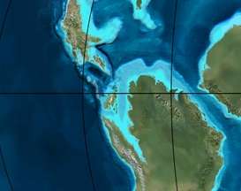 | Hiló | Chiquinquirá | Tibasosa | Une | ||||||||
| Tablazo | Tablazo | Capotes - La Palma - Simití | Simití | Tibú-Mercedes | |||||||||
| Aptian | Capotes | Socotá - El Peñón | Paja | Fómeque | |||||||||
| Paja | Paja | El Peñón | Trincheras | Río Negro | |||||||||
| La Naveta | |||||||||||||
| Barremian | 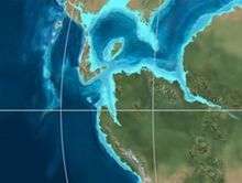 | ||||||||||||
| Hauterivian | Muzo | Cáqueza | Las Juntas | ||||||||||
| Rosablanca | Ritoque | ||||||||||||
| Valanginian | Ritoque | Furatena | Útica - Murca | Rosablanca | Girón | Macanal | |||||||
| Rosablanca | |||||||||||||
| Berriasian | | Cumbre | Cumbre | Los Medios | Guavio | ||||||||
| Tambor | Arcabuco | Cumbre | |||||||||||
| Sources | |||||||||||||
See also
References
- Acosta & Ulloa, 2002, p.51
Bibliography
- Acosta Garay, Jorge E., and Carlos E. Ulloa Melo. 2002. Mapa Geológico del Departamento de Cundinamarca - 1:250,000 - Memoria explicativa, 1–108. INGEOMINAS. Accessed 2017-04-26.
- García González, Mario; Ricardo Mier Umaña; Luis Enrique Cruz Guevara, and Mauricio Vásquez. 2009. Informe Ejecutivo - evaluación del potencial hidrocarburífero de las cuencas colombianas, 1-219. Universidad Industrial de Santander.
- Villamil, Tomas. 2012. Chronology Relative Sea Level History and a New Sequence Stratigraphic Model for Basinal Cretaceous Facies of Colombia, 161–216. Society for Sedimentary Geology (SEPM).
Maps
- Acosta, Jorge E, and Carlos E. Ulloa. 1998. Plancha 246 - Geología de Fusagasugá - 1:100,000, 1. INGEOMINAS.
- Ulloa, Carlos E; Erasmo Rodríguez, and Jorge E. Acosta. 1998. Plancha 227 - Geología de La Mesa - 1:100,000, 1. INGEOMINAS.
- Ulloa, Carlos E; Erasmo Rodríguez, and Ricardo Escovar. 1998. Plancha 192 - Geología de Laguna de Tota - 1:100,000, 1. INGEOMINAS.
- Renzoni, Giancarlo; Humberto Rosas, and Fernando Etayo Serna. 1998. Plancha 191 - Geología de Tunja - 1:100,000, 1. INGEOMINAS.
- Fuquen M., Jaime A, and José F. Osorno M. 2009. Plancha 190 - Geología de Chiquinquirá - 1:100,000, 1. INGEOMINAS.
- Ulloa, Carlos E; Álvaro Guerra, and Ricardo Escovar. 1998. Plancha 172 - Geología de Paz de Río - 1:100,000, 1. INGEOMINAS.
- Velandia, Francisco, and Héctor Cepeda. 2005. Planchas 171 & 191 - Geología sector del sur del municipio de Paipa (Boyacá) - 1:25,000. INGEOMINAS.
External links
- Gómez, J.; N.E. Montes; Á. Nivia, and H. Diederix. 2015. Plancha 5-09 del Atlas Geológico de Colombia 2015 – escala 1:500,000, 1. Servicio Geológico Colombiano. Accessed 2017-03-16.
| Geology |
|  | |||
|---|---|---|---|---|---|
| History |
| ||||
| Main mining areas |
| ||||
| Individual mines | |||||
| Individual emeralds (ct) |
| ||||
| Related articles | |||||
| |||||