Las Juntas Formation
The Las Juntas Formation or Las Juntas Sandstone (Spanish: (Formación) Areniscas de Las Juntas, Kiaj, Kialj, K1j) is a geological formation of the Altiplano Cundiboyacense and Tenza Valley, Eastern Ranges of the Colombian Andes. The Las Juntas Formation is found in the departments Cundinamarca, Boyacá and Casanare. The predominantly sandstone formation dates to the Early Cretaceous period; Hauterivian epoch, and has a maximum thickness of 910 metres (2,990 ft).
| Las Juntas Formation Stratigraphic range: Hauterivian ~132–130 Ma | |
|---|---|
| Type | Geological formation |
| Unit of | Cáqueza Group |
| Sub-units | Arenisca de Almeida Mb. Lutitas Intermedias Mb. Arenisca de El Volador Mb. |
| Underlies | Fómeque Fm., Apón Fm. |
| Overlies | Macanal Formation |
| Thickness | up to 910 m (2,990 ft) |
| Lithology | |
| Primary | Sandstone |
| Other | Shale |
| Location | |
| Coordinates | 5°00′49″N 73°27′27″W |
| Region | Altiplano Cundiboyacense & Tenza Valley Eastern Ranges Andes |
| Country | |
| Type section | |
| Named for | Cerro Las Juntas |
| Named by | Rodríguez & Ulloa |
| Location | Guateque |
| Year defined | 1979 |
| Coordinates | 5°00′49″N 73°27′27″W |
| Region | Boyacá |
| Country | |
Etymology
The formation was defined and named in 1979 by Rodríguez and Ulloa after Cerro Las Juntas, Guateque, Tenza Valley, Boyacá.[1][2]
Description
Lithologies
The Las Juntas Formation has a maximum thickness of 910 metres (2,990 ft) and is characterised by a sequence of sandstones with interbedded shales.[1]
Stratigraphy and depositional environment
The Las Juntas Formation, the uppermost unit of the Cáqueza Group, overlies the Macanal Formation and is overlain by the Fómeque Formation and the Apón Formation in the Sierra Nevada del Cocuy.[3] The formation is subdivided into three members, from old to younger; Arenisca de El Volador, Lutitas Intermedias and Arenisca de Almeida. The age has been estimated to be Hauterivian. The formation has been deposited in a near shore deltaic environment,[1][2] with as provenance areas the Santander High and the Guiana Shield.[4] The formation represents a regressive sequence in the present-day Eastern Ranges, as the Rosablanca Formation in the Middle Magdalena Valley.[5]
Outcrops
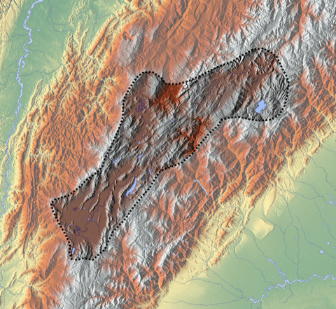
The Las Juntas Formation is apart from its type locality east of Guateque, found in Chingaza National Park,[1] in the El Cochal Synclinal east of the Ocetá Páramo,[6] between Lake Tota and Labranzagrande,[7] other parts of the Tenza Valley such as close to Macanal and Almeida.[8]
The Támara Fault thrusts the Las Juntas Formation southeastward on top of the Tertiary San Fernando and Diablo Formations,[9] and the Chámeza Fault thrusts the older Macanal Formation on top of the Las Juntas Formation around Chámeza, Casanare.[10]
Regional correlations
| Age | Paleomap | VMM | Guaduas-Vélez | W Emerald Belt | Villeta anticlinal | Chiquinquirá- Arcabuco | Tunja- Duitama | Altiplano Cundiboyacense | El Cocuy | ||||
|---|---|---|---|---|---|---|---|---|---|---|---|---|---|
| Maastrichtian |  | Umir | Córdoba | Seca | eroded | Guaduas | Colón-Mito Juan | ||||||
| Umir | Guadalupe | ||||||||||||
| Campanian | Córdoba | ||||||||||||
| Oliní | |||||||||||||
| Santonian | La Luna | Cimarrona - La Tabla | La Luna | ||||||||||
| Coniacian | Oliní | Conejo | Chipaque | ||||||||||
Güagüaquí | Loma Gorda | undefined | La Frontera | ||||||||||
| Turonian |  | Hondita | La Frontera | Otanche | |||||||||
| Cenomanian | Simití | hiatus | La Corona | Simijaca | Capacho | ||||||||
| Pacho Fm. | Hiló - Pacho | Churuvita | Une | Aguardiente | |||||||||
| Albian |  | Hiló | Chiquinquirá | Tibasosa | Une | ||||||||
| Tablazo | Tablazo | Capotes - La Palma - Simití | Simití | Tibú-Mercedes | |||||||||
| Aptian | Capotes | Socotá - El Peñón | Paja | Fómeque | |||||||||
| Paja | Paja | El Peñón | Trincheras | Río Negro | |||||||||
| La Naveta | |||||||||||||
| Barremian |  | ||||||||||||
| Hauterivian | Muzo | Cáqueza | Las Juntas | ||||||||||
| Rosablanca | Ritoque | ||||||||||||
| Valanginian | Ritoque | Furatena | Útica - Murca | Rosablanca | Girón | Macanal | |||||||
| Rosablanca | |||||||||||||
| Berriasian |  | Cumbre | Cumbre | Los Medios | Guavio | ||||||||
| Tambor | Arcabuco | Cumbre | |||||||||||
| Sources | |||||||||||||
| Ma | Age | Paleomap | Regional events | Catatumbo | Cordillera | proximal Llanos | distal Llanos | Putumayo | VSM | Environments | Maximum thickness | Petroleum geology | Notes |
|---|---|---|---|---|---|---|---|---|---|---|---|---|---|
| 0.01 | Holocene |  | Holocene volcanism Seismic activity | alluvium | Overburden | ||||||||
| 1 | Pleistocene |  | Pleistocene volcanism Andean orogeny 3 Glaciations | Guayabo | Soatá Sabana | Necesidad | Guayabo | Gigante Neiva | Alluvial to fluvial (Guayabo) | 550 m (1,800 ft) (Guayabo) | [11][12][13][14] | ||
| 2.6 | Pliocene |  | Pliocene volcanism Andean orogeny 3 GABI | Subachoque | |||||||||
| 5.3 | Messinian | Andean orogeny 3 Foreland | Marichuela | Caimán | Honda | [13][15] | |||||||
| 13.5 | Langhian | Regional flooding | León | hiatus | Caja | León | Lacustrine (León) | 400 m (1,300 ft) (León) | Seal | [14][16] | |||
| 16.2 | Burdigalian | Miocene inundations Andean orogeny 2 | C1 | Carbonera C1 | Ospina | Proximal fluvio-deltaic (C1) | 850 m (2,790 ft) (Carbonera) | Reservoir | [15][14] | ||||
| 17.3 | C2 | Carbonera C2 | Distal lacustrine-deltaic (C2) | Seal | |||||||||
| 19 | C3 | Carbonera C3 | Proximal fluvio-deltaic (C3) | Reservoir | |||||||||
| 21 | Early Miocene | Pebas wetlands | C4 | Carbonera C4 | Barzalosa | Distal fluvio-deltaic (C4) | Seal | ||||||
| 23 | Late Oligocene |  | Andean orogeny 1 Foredeep | C5 | Carbonera C5 | Orito | Proximal fluvio-deltaic (C5) | Reservoir | [12][15] | ||||
| 25 | C6 | Carbonera C6 | Distal fluvio-lacustrine (C6) | Seal | |||||||||
| 28 | Early Oligocene | C7 | C7 | Pepino | Gualanday | Proximal deltaic-marine (C7) | Reservoir | [12][15][17] | |||||
| 32 | Oligo-Eocene | C8 | Usme | C8 | onlap | Marine-deltaic (C8) | Seal Source | [17] | |||||
| 35 | Late Eocene |  | Mirador | Mirador | Coastal (Mirador) | 240 m (790 ft) (Mirador) | Reservoir | [14][18] | |||||
| 40 | Middle Eocene | Regadera | hiatus | ||||||||||
| 45 | |||||||||||||
| 50 | Early Eocene | | Socha | Los Cuervos | Deltaic (Los Cuervos) | 260 m (850 ft) (Los Cuervos) | Seal Source | [14][18] | |||||
| 55 | Late Paleocene | PETM 2000 ppm CO2 | Los Cuervos | Bogotá | Gualanday | ||||||||
| 60 | Early Paleocene | SALMA | Barco | Guaduas | Barco | Rumiyaco | Fluvial (Barco) | 225 m (738 ft) (Barco) | Reservoir | [11][12][15][14][19] | |||
| 65 | Maastrichtian | | KT extinction | Catatumbo | Guadalupe | Monserrate | Deltaic-fluvial (Guadalupe) | 750 m (2,460 ft) (Guadalupe) | Reservoir | [11][14] | |||
| 72 | Campanian | End of rifting | Colón-Mito Juan | [14][20] | |||||||||
| 83 | Santonian | Villeta/Güagüaquí | |||||||||||
| 86 | Coniacian | ||||||||||||
| 89 | Turonian | Cenomanian-Turonian anoxic event | La Luna | Chipaque | Gachetá | hiatus | Restricted marine (all) | 500 m (1,600 ft) (Gachetá) | Source | [11][14][21] | |||
| 93 | Cenomanian | | Rift 2 | ||||||||||
| 100 | Albian | Une | Une | Caballos | Deltaic (Une) | 500 m (1,600 ft) (Une) | Reservoir | [15][21] | |||||
| 113 | Aptian | | Capacho | Fómeque | Motema | Yaví | Open marine (Fómeque) | 800 m (2,600 ft) (Fómeque) | Source (Fóm) | [12][14][22] | |||
| 125 | Barremian | High biodiversity | Aguardiente | Paja | Shallow to open marine (Paja) | 940 m (3,080 ft) (Paja) | Reservoir | [11] | |||||
| 129 | Hauterivian | | Rift 1 | Tibú- Mercedes | Las Juntas | hiatus | Deltaic (Las Juntas) | 910 m (2,990 ft) (Las Juntas) | Reservoir (LJun) | [11] | |||
| 133 | Valanginian | Río Negro | Cáqueza Macanal Rosablanca | Restricted marine (Macanal) | 2,935 m (9,629 ft) (Macanal) | Source (Mac) | [12][23] | ||||||
| 140 | Berriasian | Girón | |||||||||||
| 145 | Tithonian | Break-up of Pangea | Jordán | Arcabuco | Buenavista Batá | Saldaña | Alluvial, fluvial (Buenavista) | 110 m (360 ft) (Buenavista) | "Jurassic" | [15][24] | |||
| 150 | Early-Mid Jurassic |  | Passive margin 2 | La Quinta | Montebel Noreán | hiatus | Coastal tuff (La Quinta) | 100 m (330 ft) (La Quinta) | [25] | ||||
| 201 | Late Triassic |  | Mucuchachi | Payandé | [15] | ||||||||
| 235 | Early Triassic |  | Pangea | hiatus | "Paleozoic" | ||||||||
| 250 | Permian |  | |||||||||||
| 300 | Late Carboniferous |  | Famatinian orogeny | Cerro Neiva () | [26] | ||||||||
| 340 | Early Carboniferous | Fossil fish Romer's gap | Cuche (355-385) | Farallones () | Deltaic, estuarine (Cuche) | 900 m (3,000 ft) (Cuche) | |||||||
| 360 | Late Devonian |  | Passive margin 1 | Río Cachirí (360-419) | Ambicá () | Alluvial-fluvial-reef (Farallones) | 2,400 m (7,900 ft) (Farallones) | [23][27][28][29][30] | |||||
| 390 | Early Devonian |  | High biodiversity | Floresta (387-400) El Tíbet | Shallow marine (Floresta) | 600 m (2,000 ft) (Floresta) | |||||||
| 410 | Late Silurian | Silurian mystery | |||||||||||
| 425 | Early Silurian | align=center | colspan=6 bgcolor=darkgrey align=center | hiatus | ||||||||||
| 440 | Late Ordovician |  | Rich fauna in Bolivia | San Pedro (450-490) | Duda () | ||||||||
| 470 | Early Ordovician | First fossils | Busbanzá (>470±22) Chuscales Otengá | Guape () | Río Nevado () | Hígado () | [31][32][33] | ||||||
| 488 | Late Cambrian |  | Regional intrusions | Chicamocha (490-515) | Quetame () | Ariarí () | SJ del Guaviare (490-590) | San Isidro () | [34][35] | ||||
| 515 | Early Cambrian | Cambrian explosion | [33][36] | ||||||||||
| 542 | Ediacaran |  | Break-up of Rodinia | pre-Quetame | post-Parguaza | El Barro () | Yellow: allochtonous basement (Chibcha Terrane) Green: autochtonous basement (Río Negro-Juruena Province) | Basement | [37][38] | ||||
| 600 | Neoproterozoic |  | Cariri Velhos orogeny | Bucaramanga (600-1400) | pre-Guaviare | [34] | |||||||
| 800 |  | Snowball Earth | [39] | ||||||||||
| 1000 | Mesoproterozoic |  | Sunsás orogeny | Ariarí (1000) | La Urraca (1030-1100) | [40][41][42][43] | |||||||
| 1300 | Rondônia-Juruá orogeny | pre-Ariarí | Parguaza (1300-1400) | Garzón (1180-1550) | [44] | ||||||||
| 1400 |  | pre-Bucaramanga | [45] | ||||||||||
| 1600 | Paleoproterozoic | Maimachi (1500-1700) | pre-Garzón | [46] | |||||||||
| 1800 |  | Tapajós orogeny | Mitú (1800) | [44][46] | |||||||||
| 1950 | Transamazonic orogeny | pre-Mitú | [44] | ||||||||||
| 2200 | Columbia | ||||||||||||
| 2530 | Archean |  | Carajas-Imataca orogeny | [44] | |||||||||
| 3100 | Kenorland | ||||||||||||
| Sources | |||||||||||||
- Legend
- group
- important formation
- fossiliferous formation
- minor formation
- (age in Ma)
- proximal Llanos (Medina)[note 1]
- distal Llanos (Saltarin 1A well)[note 2]
See also
Notes
References
- Acosta & Ulloa, 2002, p.52
- Rodríguez & Solano, 2000, p.47
- Villamil, 2012, p.168
- Villamil, 2012, p.165
- Villamil, 2012, p.166
- Plancha 172, 1998
- Plancha 192, 1998
- Plancha 210, 2010
- Plancha 193, 1992
- Plancha 211, 2009
- García González et al., 2009, p.27
- García González et al., 2009, p.50
- García González et al., 2009, p.85
- Barrero et al., 2007, p.60
- Barrero et al., 2007, p.58
- Plancha 111, 2001, p.29
- Plancha 177, 2015, p.39
- Plancha 111, 2001, p.26
- Plancha 111, 2001, p.24
- Plancha 111, 2001, p.23
- Pulido & Gómez, 2001, p.32
- Pulido & Gómez, 2001, p.30
- Pulido & Gómez, 2001, pp.21-26
- Pulido & Gómez, 2001, p.28
- Correa Martínez et al., 2019, p.49
- Plancha 303, 2002, p.27
- Terraza et al., 2008, p.22
- Plancha 229, 2015, pp.46-55
- Plancha 303, 2002, p.26
- Moreno Sánchez et al., 2009, p.53
- Mantilla Figueroa et al., 2015, p.43
- Manosalva Sánchez et al., 2017, p.84
- Plancha 303, 2002, p.24
- Mantilla Figueroa et al., 2015, p.42
- Arango Mejía et al., 2012, p.25
- Plancha 350, 2011, p.49
- Pulido & Gómez, 2001, pp.17-21
- Plancha 111, 2001, p.13
- Plancha 303, 2002, p.23
- Plancha 348, 2015, p.38
- Planchas 367-414, 2003, p.35
- Toro Toro et al., 2014, p.22
- Plancha 303, 2002, p.21
- Bonilla et al., 2016, p.19
- Gómez Tapias et al., 2015, p.209
- Bonilla et al., 2016, p.22
- Duarte et al., 2019
- García González et al., 2009
- Pulido & Gómez, 2001
- García González et al., 2009, p.60
Bibliography
- Acosta Garay, Jorge E., and Carlos E. Ulloa Melo. 2002. Mapa Geológico del Departamento de Cundinamarca - 1:250,000 - Memoria explicativa, 1–108. INGEOMINAS. Accessed 2017-04-26.
- Rodríguez Parra, Antonio José, and Orlando Solano Silva. 2000. Mapa Geológico del Departamento de Boyacá - 1:250,000 - Memoria explicativa, 1–120. INGEOMINAS.
- Villamil, Tomas. 2012. Chronology Relative Sea Level History and a New Sequence Stratigraphic Model for Basinal Cretaceous Facies of Colombia, 161–216. Society for Sedimentary Geology (SEPM).
Maps
- Ulloa, Carlos E.; Álvaro Guerra, and Ricardo Escovar. 1998. Plancha 172 - Paz de Río - 1:100,000, 1. INGEOMINAS. Accessed 2017-06-06.
- Ulloa, Carlos E.; Erasmo Rodríguez, and Ricardo Escovar. 1998. Plancha 192 - Laguna de Tota - 1:100,000, 1. INGEOMINAS. Accessed 2017-06-06.
- Renzoni, Giancarlo. 1992. Plancha 193 - Yopal - 1:100,000, 1. INGEOMINAS. Accessed 2017-06-06.
- Terraza, Roberto; Giovanni Moreno; José A. Buitrago; Adrián Pérez, and Diana María Montoya. 2010. Plancha 210 - Guateque - 1:100,000, 1. INGEOMINAS. Accessed 2017-06-06.
- Ulloa, Carlos, and Erasmo Rodríguez. 2009. Plancha 211 - Tauramena - 1:100,000, 1. INGEOMINAS. Accessed 2017-06-06.
- Buitrago, José Alberto; Roberto Terraza M., and Fernando Etayo. 1998. Plancha 228 - Santafé de Bogotá Noreste - 1:100,000, 1. INGEOMINAS. Accessed 2017-06-06.
External links
- Gómez, J.; N.E. Montes; Á. Nivia, and H. Diederix. 2015. Plancha 5-09 del Atlas Geológico de Colombia 2015 – escala 1:500,000, 1. Servicio Geológico Colombiano. Accessed 2017-03-16.
| Geology |
|  | |||
|---|---|---|---|---|---|
| History |
| ||||
| Main mining areas |
| ||||
| Individual mines | |||||
| Individual emeralds (ct) |
| ||||
| Related articles | |||||
| |||||