Tsukude, Aichi
Tsukude (作手村, Tsukude-mura) was a village located in Minamishitara District, Aichi Prefecture, Japan.
Tsukude 作手村 | |
|---|---|
Former municipality | |
 Flag  Emblem | |
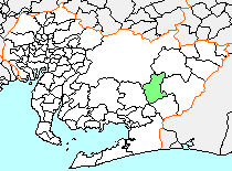 Location of Tsukude in Aichi Prefecture | |
 Tsukude Location in Japan | |
| Coordinates: 34°58′25″N 137°25′34″E | |
| Country | Japan |
| Region | Chūbu (Tōkai) |
| Prefecture | Aichi Prefecture |
| District | Minamishitara |
| Merged | October 1, 2005 (now part of Shinshiro) |
| Area | |
| • Total | 117.4 km2 (45.3 sq mi) |
| Population (September 1, 2005) | |
| • Total | 3,263 |
| • Density | 27.8/km2 (72/sq mi) |
| Symbols | |
| • Tree | Sciadopitys |
| • Flower | Habenaria radiata |
| Time zone | UTC+9 (JST) |
As of May 1, 2004, the village had an estimated population of 3,263 and a density of 27.8 persons per km². Its total area was 117.40 km².
Geography
Tsukude was located in east-central of Aichi Prefecture. Some 90 percent of the village area was covered in mountains and forest, and most was within the borders of the Aichi Kōgen Quasi-National Park
History
Tsukude was home to the Okudaira clan during the Sengoku period, and to the short-lived Tsukude Domain under the Tokugawa Shogunate of the Edo period.
Modern Tsukude village was created through the merger of nine small hamlets on May 1, 1906.
On October 1, 2005, Tsukude, along with the town of Hōrai (also from Minamishitara District), was merged into the expanded city of Shinshiro and has ceased to exist as an independent municipality.
| Authority control |
|
|---|