Feni District
Feni is a district located in the South-Eastern part of Bangladesh. It is an Administrative division of Chittagong . As of 2015, the district's estimated population stood at 1,437,371, making it the ninth-most populous district in Chittagong Division. Feni was the part of Greater Noakhali. The administrative hub of the district is in Feni City, which also serves as the headquarters of Feni Sadar Upazila in the central section of the district. The original name of the district was Shamshernagar, which served as a mahakuma under the district of Noakhali until 15 February 1984.[2] The district consists of six sub-districts: Sonagazi, Fulgazi, Parshuram, Daganbhuiyan, Chhagalnaiya and Feni Sadar.
Feni | |
|---|---|
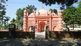 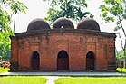 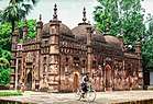 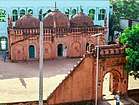 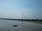 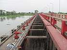 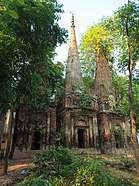 From top: Asgar Ali Chowdhury Mosque, Sharshadi Shahi Mosque, Chandgaji Bhuiyan Mosque, Mohammad Ali chowdhury mosque, Wind electricity-Muhuri Project and Feni ShathMoth | |
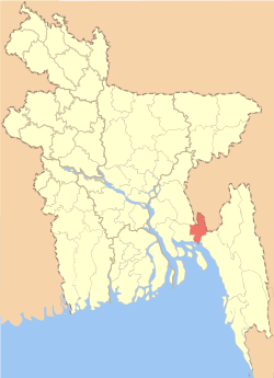 Location of Feni District within Bangladesh | |
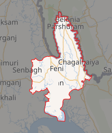
Expandable map of Feni District | |
| Coordinates: 23°00′N 91°24′E | |
| Country | |
| Division | Chittagong Division |
| Formed | 15 February 1984 |
| Government | |
| • Deputy Commissioner | Md Wahiduzzaman |
| Area | |
| • District | 928.34 km2 (358.43 sq mi) |
| • Metro | 197.33 km2 (76.19 sq mi) |
| Population (2015) | |
| • District | 1,437,371 |
| • Density | 1,500/km2 (4,000/sq mi) |
| Literacy rate | |
| • Total | 59.60% |
| Time zone | UTC+06:00 (BST) |
| Postal code | 3900 |
| HDI (2018) | 0.596[1] medium · 11th of 21 |
| Calling code | 0331 |
| Notable sport teams | Feni SC |
| Website | Official Website |
History
In the opinion of most historians, the area of this district is more ancient than the other areas of the greater Noakhali region. Many archaeological antiquities were found in this district which proves the claim. In ancient times, maximum area of the Noakhali region was under water except this area.
Before 1984, it was a mahakuma of Noakhali district. In 1872-74, Amirgaon thana which was established by the Mughals was facing river erosion. Then it was moved to Khaiarat which was situated by the river Feni. Then this area was known as Feni because of the river. It was established as a mahakuma with three thanas named Mirsarai, Chhagalnaiya and Amirgaon in 1875. Later, Mirsarai was included in Chittagong district. In 1976, a new mahakuma was established and the Khaiarat thana was moved to this new mahakuma and the mahakuma was named Feni. The first headquarter of the mahakuma was in Amirgaon thana. It was moved to Feni in 1881. During the administrative reconstruction in 1984, all the mahakumas were upgraded to districts and Feni became one of them.[3]
Etymology
The name "Feni" was derived from Feni river. The name "Feni" ( ফেনী in Bengali language) can be found in the literary works of poets during the 16th century as river stream and as a ghat for ferry crossing. Kbindra Parameshwar used the word describing the description of Paragalpur. In 17th century, in the Persian book "Baharistan-i-Ghaibi" , written by Mirza Nathan the word "Feni" became "Feni". In the literary works of poets, the word was used as a river.[3]
Geography
Feni has a total area of 928.34 sq. km. It has boundaries with Comilla district and Tripura state of India in the north, Chittagong district and Bay of Bengal in the south, Chittagong district and Tripura state in the east and Noakhali district in the west. Feni district has 6 upazilas and 43 unions. Feni, Mahuri, Kuhuri, Silonia and Kalidas Pahalia river are some of the major rivers of the district. Total forest area in the district is 2179.22 hectares.[4] [5]
Administration[6]
Feni district has 6 upazilas, 6 thanas, 5 municipalities, 43 unions, 564 villages and 540 mouzas.[7]
| Name of Upazila | Area (Square k.m) | Headquarter | Union | Population |
|---|---|---|---|---|
| Feni Sadar Upazila | 197.33 | Feni | 12 | 404,498 |
| Daganbhuiyan Upazila | 165.84 | Daganbhuiyan | 8 | 225,464 |
| Chhagalnaiya Upazila | 133.49 | Chhagalnaiya | 6 | 170,524 |
| Sonagazi Upazila | 205.07 | Sonagazi | 9 | 235,229 |
| Parshuram Upazila | 97.57 | Parshuram | 3 | 94,378 |
| Fulgazi Upazila | 99.03 | Fulgazi | 6 | 110,291 |
Demographics
The total population of the district is 1,496,138. Total number of male and female is 722,626 and 773,512 respectively. Males constituted 48.30% and females constituted 51.70% of the population. Majority of the people of this area are Muslim. 78.70% of the total population are Muslim, 21.14% are Hindus, 0.02% are Buddhists, 0.003% are Christians and 0.02% are others.[5][6]
Economy
The main occupation of the people of the district are agriculture & Foreign Remittance. The main source of incomes are: agriculture 21%, non-agricultural labourer 2.57%, industry 35%, commerce 15.98%, transport and communication 4.66%, construction 1.86%, religious service 0.43%, rent and remittance 11.53% and others 12.19%. There are two industrial areas in this district. Total number of heavy industries are 4, medium industries are 17, small industries are 826 and cottage industries are 3419. There is a gas field in Dhalia union of Feni sadar area. Total area of agriculture land is 75,922 hectares and arable land is 74,720 hectare.[5][6]
Education
The literacy rate of the district is 59.60%. There are many of degree college, 10 higher secondary colleges, one girls' cadet college, one polytechnic institute, one computer institute, 155 high schools, 19 junior secondary schools, 97 madrasas, one teachers training college, one primary teachers training institute and 528 government primary schools. Major educational institutions are:
Health
There are one modern government general hospital, 5 upazila health complexes, one heart foundation hospital, one diabetic hospital, one chest disease clinic (Tuberculosis), one trauma center, one mother and child care center, one nursing training institute, 19 union health centers, 33 union family care centers and 114 community clinics.[5]
Transportation
There is direct connection to the district from Dhaka. Total length of national highway is 31 km (Dhaka-Chittagong) and 20 km (Feni-Noakhali). Total length of concrete road is 1044.85 km, half-concrete road is 87.96 km and dirt road is 2,132.96 km. Star line travels, S. Alam travels, Keya travels, Saudia travels, Shyamoli travels, Sohag travels, Unique travels, Green Line travels etc. are major inter-division bus travel agencies.
Mahanagar Pravati, Paharika, Meghna, Udayan, Mahanagar Godhuli. Turnanishitha, Chattagram Mail, Karnaphuli, Jalalabad, Sagarika and Mymensingh Express are the trains servicing the district to travel various district.[8]
Member of the 11th parliament[9]
| Seat | Name of MP | Political Party |
|---|---|---|
| Feni-1 | Shirin Akhter | Jatiya Samajtantrik Dal |
| Feni-2 | Nizam Uddin Hazari | Bangladesh Awami League |
| Feni-3 (Sonagazi) | Masud Uddin Chowdhury | Jatiya Party |
Notable people[10]
- Habibullah Bahar Chowdhury, first health minister of East Pakistan, one of the founders of Mohammedan Sporting Club (Kolkata)
- Shamsunnahar Mahmud, politician and educator
- Abdus Salam , Bengali language movement protester
- Selina Parvin, writer and journalist
- Shahidullah Kaiser, novelist and journalist
- Zahir Raihan, movie director and writer
- Selim Al Deen, writer
- Anwarullah Chowdhury Vice-chancellor of the University of Dhaka
- Joynal Hazari, journalist
- Khaleda Zia, former prime minister of Bangladesh
- Aurangzeb Chowdhury, Chief of Navy
- Selim Al Deen, notable playwright and theater artist
- Abul Kalam Azad Chowdhury former Vice Chancellor of the University of Dhaka
- Mohammad Saifuddin, Bangladeshi cricketer
- Abdus Salam (editor), Former editor of the Pakistan Observer (later the Bangladesh Observer). Ekushey Padak winning journalist
See also
References
- "Sub-national HDI - Area Database - Global Data Lab". hdi.globaldatalab.org. Retrieved 2020-03-18.
- Sultan, Tipu (2012). "Feni District". In Islam, Sirajul; Jamal, Ahmed A. (eds.). Banglapedia: National Encyclopedia of Bangladesh (Second ed.). Asiatic Society of Bangladesh.
- "History of district". Bangladesh national portal.
- "Rivers of district". Bangladesh national portal.
- "District at a glance". Bangladesh national portal.
- "Feni district". Banglapedia.
- "প্রশাসনিক কাঠামো". feni.gov.bd. Archived from the original on 14 April 2014. Retrieved 14 July 2014.
- "Transportation of district". Bangladesh national portal.
- "List of 11th parliament member of Bangladesh". Bangladesh national parliament.
- "Notable people of the district". Bangladesh national portal.
External links
| Wikimedia Commons has media related to Feni District. |
