Rural Municipality of Hudson Bay No. 394
The Rural Municipality of Hudson Bay No. 394 (2016 population: 1,114) is a rural municipality (RM) in the Canadian province of Saskatchewan within Census Division No. 14 and SARM Division No. 4. It is located in the northeast-central portion of the province.
Hudson Bay No. 394 | |
|---|---|
| Rural Municipality of Hudson Bay No. 394 | |
 Location of the RM of Hudson Bay No. 394 in Saskatchewan | |
| Coordinates: 53.137°N 102.206°W[1] | |
| Country | Canada |
| Province | Saskatchewan |
| Census division | 14 |
| SARM division | 4 |
| Federal riding | Desnethé—Missinippi—Churchill River Yorkton—Melville |
| Provincial riding | Carrot River Valley |
| Formed[2] | May 1, 1977 |
| Government | |
| • Reeve | Neal Hardy |
| • Governing body | RM of Hudson Bay No. 394 Council |
| • Administrator | Tracy Smith |
| • Office location | Hudson Bay |
| Area (2016)[4] | |
| • Land | 12,462.61 km2 (4,811.84 sq mi) |
| Population (2016)[4] | |
| • Total | 1,114 |
| • Density | 0.1/km2 (0.3/sq mi) |
| Time zone | CST |
| • Summer (DST) | CST |
| Postal code | S0E 0Y0 |
| Area code(s) | 306 and 639 |
History
The RM of Hudson Bay No. 394 incorporated as a rural municipality on May 1, 1977.[2]
Geography
Communities and localities
The following urban municipalities are surrounded by the RM.
The following unincorporated communities are within the RM.
- Organized hamlets[5]
- Localities
- Akosane
- Bertwell
- Etomami
- Hudson Bay Junction
- Reserve
- Veillardville
The RM also surrounds several First Nations communities.
Demographics
In the 2016 Census of Population conducted by Statistics Canada, the RM of Hudson Bay No. 394 recorded a population of 1,114 living in 485 of its 852 total private dwellings, a -0.7% change from its 2011 population of 1,122. With a land area of 12,462.61 km2 (4,811.84 sq mi), it had a population density of 0.1/km2 (0.2/sq mi) in 2016.[4] It is the largest and least densely populated rural municipality in Saskatchewan.
In the 2011 Census of Population, the RM of Hudson Bay No. 394 recorded a population of 1,122, a -17.4% change from its 2006 population of 1,359. With a land area of 12,462.61 km2 (4,811.84 sq mi), it had a population density of 0.1/km2 (0.2/sq mi) in 2011.[8]
Government
The RM of Hudson Bay No. 394 is governed by an elected municipal council and an appointed administrator that meets on the second Tuesday of every month.[3] The reeve of the RM is Neal Hardy while its administrator is Tracy Smith.[3] The RM's office is located in Hudson Bay.[3]
Transportation
- Rail[9]
- Hudson Bay Branch C.N.R. - serves Hudson Bay Junction, Wachee, Ceba, Chemong)
- Swan River - Prince Albert Branch C.N.R. - serves Baden, Powell, Barrows Junction, Westgate, Roscoe, Erwood, Hudson Bay Junction, Greenbush, Prairie River, Bannock, Mistatim, Peesane, Crooked River, Eldersley, Tisdale, Valparaiso
- Roads[10]
- Highway 3—serves Hudson Bay and Erwood
- Highway 9—serves Hudson Bay
- Highway 55—Comes near Shoal Lake First Nation and Red Earth First Nation
- Highway 980—serves Woody River Recreation Site
- Highway 981—serves Erwood
- Highway 982 (Little Swan Road)—connects Hudson Bay and Swan Plain, Saskatchewan
- Highway 983 (McBride Lake Road)—serves Reserve
References
- "Pre-packaged CSV files - CGN, Canada/Province/Territory (cgn_sk_csv_eng.zip)". Government of Canada. July 24, 2019. Retrieved May 23, 2020.
- "Rural Municipality Incorporations (Alphabetical)". Saskatchewan Ministry of Municipal Affairs. Archived from the original on April 21, 2011. Retrieved May 9, 2020.
- "Municipality Details: RM of Hudson Bay No. 394". Government of Saskatchewan. Retrieved May 21, 2020.
- "Population and dwelling counts, for Canada, provinces and territories, and census subdivisions (municipalities), 2016 and 2011 censuses – 100% data (Saskatchewan)". Statistics Canada. February 8, 2017. Retrieved May 1, 2020.
- "2019-2020 Rural Revenue Sharing Organized Hamlet Grant". Government of Saskatchewan. Retrieved May 4, 2020.
- "Saskatchewan Census Population" (PDF). Saskatchewan Bureau of Statistics. Archived from the original (PDF) on September 24, 2015. Retrieved May 9, 2020.
- "Saskatchewan Census Population". Saskatchewan Bureau of Statistics. Retrieved May 9, 2020.
- "Population and dwelling counts, for Canada, provinces and territories, and census subdivisions (municipalities), 2011 and 2006 censuses (Saskatchewan)". Statistics Canada. June 3, 2019. Retrieved May 1, 2020.
- Canadian Maps: January 1925 Waghorn's Guide. Post Offices in Man. Sask. Alta. and West Ontario.
- Eversoft Streets and Trips
Places adjacent to Rural Municipality of Hudson Bay No. 394 | |
|---|---|
| Cities | 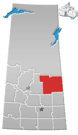 | |
|---|---|---|
| Towns | ||
| Villages | ||
| Resort villages | ||
| Rural municipalities |
| |
| First Nations | ||
| Indian reserves | ||
| Unincorporated communities | ||