Shilin District
Shilin District (also spelled Shihlin District)(Mandarin Chinese:士林區; Taiwanese:士林區; Pinyin:shì línqū;Taiwanese Pinyin: Sū lîm khu) is a district of Taipei and home to a large foreign population, mainly concentrated in the Tianmu area. It has long been a top choice for expatriates from Europe, US, Canada, Southeast Asia and Japan to live, run businesses, and establish embassies and offices[1] due mainly to the natural environment—sitting at the foot of Yangmingshan—and because the international schools are all located here. The central command of the Republic of China Navy is located in Shilin.
Shilin 士林區 Shihlin | |
|---|---|
| Shilin District | |
 | |
 | |
| Country | Republic of China (Taiwan) |
| Region | Northern Taipei |
| Divisions | List
|
| Area | |
| • Total | 62.3682 km2 (24.0805 sq mi) |
| Area rank | Ranked 1st of 12 |
| Population (January 2016) | |
| • Total | 290,682 |
| • Rank | Ranked 2nd of 12 |
| • Density | 4,700/km2 (12,000/sq mi) |
| Postal code | 111 |
| Shilin District | |||||||||||
|---|---|---|---|---|---|---|---|---|---|---|---|
| Chinese name | |||||||||||
| Traditional Chinese | 士林區 | ||||||||||
| Simplified Chinese | 士林区 | ||||||||||
| |||||||||||
| Alternative Chinese name | |||||||||||
| Traditional Chinese | 八芝蘭 | ||||||||||
| Simplified Chinese | 八芝兰 | ||||||||||
| |||||||||||
| Ketagalan name | |||||||||||
| Ketagalan | Pattsiran | ||||||||||
| (Ketagalan word for "hot spring"; transliterated into Chinese as "八芝蘭" Bāzhīlán) (old name) | |||||||||||
History
The name Shilin was derived from Pattsiran, the Ketagalan word for "hot springs". It was then transliterated into Chinese as "八芝蘭" (pinyin: Bāzhīlán; Pe̍h-ōe-jī: Pat-chi-lân), which has been written as Pat-chi-na or Pachina.[2]
Prior to Han settlement, the area was home to the Kimassauw community (麻少翁社) of the Taiwanese Plains Aborigines. During the Qing era, a fort was set up, later called Zhilan Yi Bao (first fort/settlement of Pattsiran, 芝蘭一堡). By the late Qing dynasty, "many literary talents from Shilin had passed the imperial examination", prompting the local gentry to rename it Shilin (士林), meaning "congregation of scholars and talents".[1][3]
In 1920 under Japanese rule, the area was organized as Shirin Village (士林莊) and in 1933 Shirin Town (士林街), under Shichisei District (七星郡), Taihoku Prefecture. In 1945 after World War II, it was modified to Shilin Township (士林鎭), Taipei County (臺北縣).
Shilin is foremost a residential district and has several famous neighborhoods, such as Waishuangxi (外雙溪) and Tianmu. Kuomintang leader Chiang Kai-shek lived in Shilin after moving the Chinese Nationalist government to Taiwan after the Chinese Civil War. The district is divided up into 51 villages (里), which are further divided up into 987 neighborhoods (鄰).
The district can be said to be the origin of culture in Taipei.[1] During the Qing Dynasty, many private, public and community schools were opened in the area. During the Japanese era, a national learning center was set up at Zhishanyan.[1]
Education
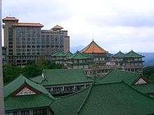
Shilin has three universities: Ming Chuan University, Soochow University, and the Chinese Culture University. Several international schools, including the Taipei American School, Taipei Japanese School, The Primacy Collegiate Academy and Taipei European School are located in this district. The district is also home to two vocational colleges, four senior high schools, eight junior high schools, and twenty elementary schools.[1]
The National Taiwan Science Education Center also is located in this district, along with the Taipei Astronomical Museum, the Shung Ye Museum of Formosan Aborigines, and the world-renowned National Palace Museum.
Tourism

The district is home to many national historical sites, including historical temples, markets, and buildings. Tourist attractions include:
- Yangmingshan National Park
- Shihlin Paper Mill
- National Palace Museum
- Taipei Astronomical Museum
- National Science Taiwan Education Center
- Chien Mu House
- Hwa Kang Museum
- Chiang Kai-shek's Shilin Official Residence
- Shilin Shennong Temple
- Lin Yutang House
- Tianmu White House
- Taiwan Traditional Theatre Center
- Chin Shan Yen Hui Chi Temple
- Chin Shan Yen Gate
- Taipei Children's Amusement Park
- Shilin Night Market
- Shilin Cixian Temple
The Tatun Volcano Group is located northeast of the district. The district is also the location of the Tianmu Baseball Stadium, Bailing Sport Park, Shilin Fitness Center and Chinese Culture and Movie Center. The Shuangxi Park and Chinese Garden is also located in Shilin.
Transportation

In addition to many bus lines, the district is served by the Taipei Metro Tamsui Line. It is served by Provincial Highway No. 2 and many other main roads through the city.
Sister cities
- Los Altos, California, USA
- Walnut, California, USA
Notable natives
- Chang Hsin-yan, actress
- Ko Chia-yen, actress
- Miu Chu, singer
- Selina Jen, singer and actress
See also
References
- "About Shilin District". Taipei City Government. 28 January 2010. Retrieved 14 July 2010.
- Davidson, James W. (1903). The Island of Formosa, Past and Present : history, people, resources, and commercial prospects : tea, camphor, sugar, gold, coal, sulphur, economical plants, and other productions. London and New York: Macmillan. OL 6931635M.CS1 maint: ref=harv (link)
- alternately, "scholars enter the forest" (士子如林). 士林區. Taipei Link (in Chinese). Retrieved 11 January 2015.
External links
| Wikimedia Commons has media related to Shilin District, Taipei. |

- Shilin District Office, Taipei City