Maolin District
Maolin District (Rukai: Teldreka; Chinese: 茂林區; pinyin: Màolín Qū) is a mountain indigenous district of Kaohsiung, Taiwan. Maolin is one of the least populated districts in Taiwan, since it is located just to the south of the Central Mountain Range. The height ranges from 230 meters to 2700 meters above sea level, with a hot tropical and humid weather. The main population of Maolin district is the indigenous Rukai people. Maolin is well suited for tourism due to its unique scenery and ecology. Maolin National Scenic Area is located in the district.
Maolin 茂林區 | |
|---|---|
| Maolin District [1] | |
.jpg) Wanshan Village | |
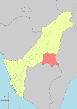 Miaolin District in Kaohsiung City | |
| Country | Taiwan |
| Municipality | Kaohsiung City |
| Boroughs | List
|
| Government | |
| • Type | District government |
| • District chief | Angopaw Komola (KMT) |
| Population (January 2016) | |
| • Total | 1,893 |
Geography
With a population of 1,915 as of December 2014, Maolin District has the fewest population among other districts in Kaohsiung.
- Area: 194 km2
- Population: 1,893 people (January 2016)
- Postal Code: 851
- Households: 584
History
During the period of Japanese rule, Maolin was grouped with modern-day Namasia and Tauyuan districts and classified as "Aboriginal Areas" (蕃地), which was governed under Kizan District (旗山郡) of Takao Prefecture.
Administrative divisions
Maolin District consists of 3 villages and 19 neighborhoods. Along with Namasia District, Maolin District has the fewest village among other districts in Kaohsiung.
- Duona Village (多納里)
- Maolin Village (茂林里)
- Wanshan Village (萬山里)
| Miaolin District administrative divisions | ||||||
|---|---|---|---|---|---|---|
 Duona Village
Maolin
Village Wanshan
Village |
Tourist attractions

- Maolin National Scenic Area
- Duona Hot Spring
- Duona Stone Houses
- Duona Suspension Bridge
- Gorge of Serenity
- Lover's Gorge(Chinese: 情人谷)
- Maolin Gorge
- Meiya Gorge(Chinese: 美雅谷)
- Mount Dragon Head
- Mount Gueishing
- Mount Serpent Head
- Old Jiadong Tree
Notable natives
- Rachel Liang, singer
- Saidai Tarovecahe, member-elect of Legislative Yuan
Transportation
References
- "Glossary of Names for Admin Divisions" (PDF). placesearch.moi.gov.tw. Ministry of Interior of the ROC. Retrieved 12 June 2015.
External links
| Wikimedia Commons has media related to Maolin District, Kaohsiung. |
| Highland aboriginal Townships and Districts | 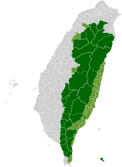 | ||||||||||||
|---|---|---|---|---|---|---|---|---|---|---|---|---|---|
| Plains aboriginal Townships and County-Controlled Cities |
| ||||||||||||
Note: On the map, "Mountain Indigenous Areas" are in dark green and "Plains Indigenous Areas" are in light green. | |||||||||||||