Portland metropolitan area
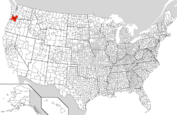
The Portland metropolitan area or Greater Portland is a metropolitan area in the U.S. states of Oregon and Washington centered on the principal city of Portland, Oregon. The U.S. Office of Management and Budget (OMB) identifies it as the Portland–Vancouver–Hillsboro, OR–WA Metropolitan Statistical Area, a metropolitan statistical area used by the United States Census Bureau (USCB) and other entities. The OMB defines the area as comprising Clackamas, Columbia, Multnomah, Washington, and Yamhill Counties in Oregon, and Clark and Skamania Counties in Washington.[1] The area's population is estimated at 2,753,168 in 2017.
Portland metropolitan area | |
|---|---|
| Portland–Vancouver–Hillsboro | |
 | |
 | |
| Coordinates: 45°30′N 122°39′W | |
| Country | United States |
| State(s) | Oregon Washington |
| Largest city | Portland, Oregon (647,505) |
| Other cities | Vancouver (183,000) Gresham (113,727) Hillsboro (110,006) Beaverton (100,648) |
| Area | |
| • Total | 6,684 sq mi (17,310 km2) |
| Highest elevation | 8,366 ft (N/A m) |
| Lowest elevation | N/A ft (N/A m) |
| Population | |
| • Total | 2,753,168 |
| • Rank | 25th in the U.S. |
| • Density | 367/sq mi (129/km2) |
The Oregon portion of the metropolitan area is the state's largest urban center, while the Washington portion of the metropolitan area is the state's third largest urban center after Seattle (the Seattle Urban Area includes Tacoma and Everett[2]) and Spokane.[3] Portions of this are under the jurisdiction of Metro,[4] a directly elected regional government which, among other things, is responsible for land-use planning in the region.
Metropolitan statistical area
| Historical population | |||
|---|---|---|---|
| Census | Pop. | %± | |
| 1860 | 16,751 | — | |
| 1870 | 30,763 | 83.6% | |
| 1880 | 57,831 | 88.0% | |
| 1890 | 130,455 | 125.6% | |
| 1900 | 172,056 | 31.9% | |
| 1910 | 330,581 | 92.1% | |
| 1920 | 409,023 | 23.7% | |
| 1930 | 500,011 | 22.2% | |
| 1940 | 553,215 | 10.6% | |
| 1950 | 766,008 | 38.5% | |
| 1960 | 881,961 | 15.1% | |
| 1970 | 1,083,977 | 22.9% | |
| 1980 | 1,341,491 | 23.8% | |
| 1990 | 1,523,741 | 13.6% | |
| 2000 | 1,927,881 | 26.5% | |
| 2010 | 2,226,009 | 15.5% | |
| Est. 2019 | 2,492,412 | 12.0% | |
| U.S. Decennial Census | |||
As of the 2010 census, there were 2,226,009 people, 867,794 households, and 551,008 families residing within the MSA. The racial makeup of the MSA were as followed:[5][6]
- White: 81.0% (Non-Hispanic White 76.3%)
- Hispanic or Latino (of any race): 10.9% (8.5% Mexican, 0.4% Spanish or Spaniard, 0.3% Guatemalan, 0.3% Puerto Rican, 0.2% Cuban, 0.2% Salvadoran, 0.1% Peruvian)
- Asian: 5.7% (1.2% Chinese, 1.2% Vietnamese, 0.7% Indian, 0.6% Filipino, 0.6% Korean, 0.4% Japanese)
- Black or African American: 2.9%
- American Indian and Alaskan Native: 0.9%
- Pacific Islander: 0.5% (0.1% Native Hawaiian, 0.1% Guamanian or Chamorro, 0.1% Samoan)
- Two or more races: 4.1%
- Some other race: 4.9%
In 2010 the median income for a household in the MSA was $53,078 and the median income for a family was $64,290. The per capita income was $27,451.[7]
The Portland–Vancouver–Hillsboro Metropolitan Statistical Area (MSA), the 23rd largest in the United States,[8][9] has a population of 2,226,009 (2010 Census). Of them, 1,789,580 live in Oregon (46.7% of the state's population) while the remaining 436,429 live in Washington (6.7% of state's population). It consists of Multnomah, Washington, Clackamas, Columbia and Yamhill counties in Oregon, as well as Clark and Skamania counties in Washington. The area includes Portland and the neighboring cities of Vancouver, Beaverton, Gresham, Hillsboro, Milwaukie, Lake Oswego, Oregon City, Fairview, Wood Village, Troutdale, Tualatin, Tigard, West Linn, Battle Ground, Camas and Washougal.
The Portland–Vancouver–Salem, OR–WA Combined Statistical Area (CSA) 2015 population estimate is 3,110,906, ranked 18th largest in the United States (2,921,408 based on the 2010 Census). This area includes the Portland–Vancouver–Hillsboro, OR–WA Metropolitan Statistical Area; Salem, OR Metropolitan Statistical Area, and other surrounding areas.[10]
Changes in house prices for the metro area are publicly tracked on a regular basis using the Case–Shiller index; the statistic is published by Standard & Poor's and is also a component of S&P's 20-city composite index of the value of the U.S. residential real estate market.
| County | 2019 Estimate | 2010 Census | Change | Area | Density |
|---|---|---|---|---|---|
| Clackamas County, Oregon | 412,672 | 375,992 | +9.76% | 1,870.32 sq mi (4,844.1 km2) | 224/sq mi (86/km2) |
| Columbia County, Oregon | 51,782 | 49,351 | +4.93% | 657.36 sq mi (1,702.6 km2) | 80/sq mi (31/km2) |
| Multnomah County, Oregon | 807,555 | 735,334 | +9.82% | 431.30 sq mi (1,117.1 km2) | 1,885/sq mi (728/km2) |
| Washington County, Oregon | 588,957 | 529,710 | +11.18% | 724.23 sq mi (1,875.7 km2) | 831/sq mi (321/km2) |
| Yamhill County, Oregon | 105,722 | 99,193 | +6.58% | 715.86 sq mi (1,854.1 km2) | 150/sq mi (58/km2) |
| Clark County, Washington | 474,643 | 425,363 | +11.59% | 629.00 sq mi (1,629.1 km2) | 956/sq mi (369/km2) |
| Skamania County, Washington | 11,837 | 11,066 | +6.97% | 1,655.68 sq mi (4,288.2 km2) | 7/sq mi (3/km2) |
| Total | 2,453,168 | 2,226,009 | +10.20% | 6,683.75 sq mi (17,310.8 km2) | 367/sq mi (142/km2) |
Cities and other communities
Major cities in the region in addition to Portland include Beaverton, Gresham, Hillsboro in Oregon, and Vancouver in Washington. The area also includes the smaller cities of Corbett, Cornelius, Damascus, Fairview, Forest Grove, Gladstone, Happy Valley, King City, Lake Oswego, Milwaukie, Oregon City, Sherwood, Tigard, Troutdale, Tualatin, West Linn, Wilsonville, Wood Village in Oregon, as well as Battle Ground, Camas, Washougal, Ridgefield, La Center and Yacolt in Washington.
It includes the unincorporated suburban communities in Oregon of Aloha, Beavercreek, Boring, Cedar Mill, Clackamas, Dunthorpe, Garden Home, Raleigh Hills, and West Slope, as well as Hazel Dell, Minnehaha, Salmon Creek, Walnut Grove and Orchards in Washington.
- Major
- Other
- Amity
- Battle Ground
- Banks
- Barlow
- Camas
- Canby
- Carlton
- Clatskanie
- Columbia City
- Cornelius
- Dayton
- Dundee
- Durham
- Estacada
- Fairview
- Forest Grove
- Gaston
- Gladstone
- Happy Valley
- Johnson City
- King City
- La Center
- Lafayette
- Lake Oswego
- Maywood Park
- McMinnville
- Milwaukie
- Molalla
- Newberg
- North Bonneville
- North Plains
- Oregon City
- Prescott
- Rainier
- Ridgefield
- Rivergrove
- St. Helens
- Sandy
- Scappoose
- Sheridan
- Sherwood
- Stevenson
- Tigard
- Troutdale
- Tualatin
- Vernonia
- Washougal
- West Linn
- Willamina
- Wilsonville
- Wood Village
- Woodland
- Yacolt
- Yamhill
Transportation
Portland is where Interstate 84 starts at Interstate 5, both major highways in the Pacific Northwest. Other primary roads include Interstate 205, an eastern bypass of the urban core, U.S. Route 26, which heads west and southeast, U.S. Route 30, which follows the Oregon side of the Columbia River northwest and east, mirrored by Washington State Route 14 east from Vancouver, and Oregon Route 217, which connects US 26 with I-5 in the south, travelling through Beaverton. Both US 26 and US 30 go to the Oregon Coast. SR 500 runs from Interstate 5 to SR 503. Padden Parkway runs from NE 78th St and east to NE 162nd Ave.
Transit service on the Oregon side is generally provided by TriMet. In addition, Sandy Area Metro serves Sandy, South Clackamas Transportation District serves nearby Molalla, Canby Area Transit serves Canby and South Metro Area Regional Transit serves Wilsonville. Service in Clark County is provided by C-Tran. In Columbia County, the Columbia County Rider provides transit service on weekdays connecting St. Helens with downtown Portland and connecting Scappoose and St. Helens with certain points in urban Washington County, including the PCC Rock Creek campus, Tanasbourne and the Willow Creek MAX light rail station.[11]
Major airports
- Portland International Airport
- Portland-Hillsboro Airport
- Salem Municipal Airport
- Portland-Troutdale Airport
Major railroad
Los Angeles, California to Seattle, Washington.
- Empire Builder 27/28 Portland Oregon section.
Spokane, Washington to Portland Oregon.
Vancouver, British Columbia, Canada to Eugene, Oregon.
Major highways
State highways, numbered as Interstate, U.S and Oregon Routes, in the metropolitan area include:


- U.S. Route 30 Business


Notable highways never built, or removed altogether, include Mount Hood Freeway, Interstate 505, and Harbor Drive.[12]
Sports
The Portland MSA is home to a number of professional and semi-professional sports teams, including the NBA's Portland Trail Blazers, the Portland Timbers of Major League Soccer, and the Portland Thorns of the National Women's Soccer League. Other teams include the Portland Pickles and the Hillsboro Hops. Portland is also home to two NCAA Division 1 universities, the Portland State Vikings and the Portland Pilots.
The Portland MSA also hosts a number of amateur sports, including college and high school sports. The high school rugby championships are held annually in the Portland MSA, and draw crowds of 8,000 to 10,000 supporters.[13]
References
- "Update of Statistical Area Definitions and Guidance on Their Uses" (PDF). Office of Management and Budget. November 20, 2007. p. 45. Archived from the original (PDF) on November 17, 2008. Retrieved 2008-09-05.
- "2010 Census Urban Area Reference Maps". USCB, Geography Division. Retrieved March 20, 2015.
- "A national, state-sorted list of all 2010 urbanized areas and urban clusters for the U.S., Puerto Rico, and Island Areas first sorted by state FIPS code, then sorted by UACE code". USCB, Geography Division. Retrieved March 20, 2015.
- "Jurisdictional Boundaries". Metro. Retrieved 2011-08-01.
- "Profile of General Population and Housing Characteristics: 2010". factfinder2.census.gov. US Census Bureau. Archived from the original on 2019-05-21.
- "Hispanic or Latino by Type: 2010". factfinder2.census.gov. US Census Bureau. Archived from the original on 2020-02-12. Retrieved 2020-04-04.
- US Census Bureau. Factfinder2.census.gov. Retrieved on 2013-10-05.
- "Table 1. Annual Estimates of the Population of Metropolitan and Micropolitan Statistical Areas: April 1, 2000 to July 1, 2008". Archived from the original on July 31, 2009. Retrieved September 2, 2016.
- "OMB Bulletin No. 10-02: Update of Statistical Area Definitions and Guidance on Their Uses" (PDF). United States Office of Management and Budget. December 1, 2009. Retrieved January 18, 2010.
- "Annual Estimates of the Resident Population: April 1, 2010 to July 1, 2015 - United States -- Combined Statistical Area; and for Puerto Rico". USCB, Population Division. March 2016. Archived from the original on August 15, 2014. Retrieved March 22, 2016.
- "Schedules & Routes". Columbia County Rider. Archived from the original on 2014-08-16. Retrieved 2014-06-12.
- Young, Bob (March 9, 2005). "Highway to Hell". Willamette Week. Retrieved November 20, 2016.
- USA Rugby, High school state championships gain rugby exposure Archived 2013-06-09 at the Wayback Machine, June 4, 2013
External links
- Metro government website
- Portland MSA 2010 Census numbers from the Population Resource Center
- pdx.edu/media/p/r/PRC_2007_Population_Report2_rev.pdf of key urban planning documents on the Portland Metropolitan area, at Portland State University
Olympia (capital) | |||||||
| Topics |
|  | |||||
| Society | |||||||
| Politics |
| ||||||
| Regions |
| ||||||
| Largest cities |
| ||||||
| Counties |
| ||||||
| Authority control |
|
|---|