Clackamas County, Oregon
Clackamas County /ˈklækəməs/ is a county in the U.S. state of Oregon. As of the 2010 United States Census, the population was 375,992,[1] making it Oregon's third-most populous county. Its county seat is Oregon City.[2] The county was named after the Native Americans living in the area, the Clackamas Indians, who are part of the Chinookan people.
Clackamas County | |
|---|---|
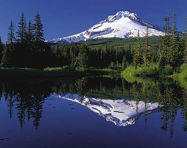
 .jpg) 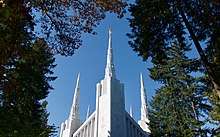 _(clacD0034).jpg)  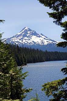 Clockwise from top: Willamette Falls, Portland Mormon Temple, Mount Hood, Oregon City Municipal Elevator, Clackamas County Courthouse, Government Camp | |
 Seal | |
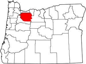 Location within the U.S. state of Oregon | |
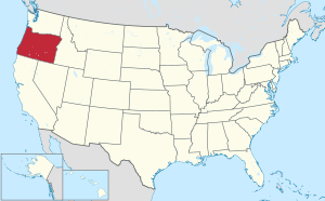 Oregon's location within the U.S. | |
| Coordinates: 45°11′N 122°13′W | |
| Country | |
| State | |
| Founded | July 5, 1843 |
| Seat | Oregon City |
| Largest city | Lake Oswego |
| Area | |
| • Total | 1,883 sq mi (4,880 km2) |
| • Land | 1,870 sq mi (4,800 km2) |
| • Water | 13 sq mi (30 km2) 0.7%% |
| Population (2010) | |
| • Total | 375,992 |
| • Estimate (2019) | 418,187 |
| • Density | 223/sq mi (86/km2) |
| Time zone | UTC−8 (Pacific) |
| • Summer (DST) | UTC−7 (PDT) |
| Congressional districts | 3rd, 5th |
| Website | www |
Clackamas County is part of the Portland-Vancouver-Hillsboro, OR-WA Metropolitan Statistical Area. It is in the Willamette Valley.
History
Originally named Clackamas District, it was one of the four original Oregon districts created by Oregon's Provisional Legislature on July 5, 1843 along with Twality (later Washington), Champooick (later Marion), and Yamhill. The four districts were redesignated as counties in 1845. At the time of its creation, Clackamas County covered portions of four present-day U.S. states and a Canadian province. The Columbia River became the northern boundary of the county in 1844. Soon after John McLoughlin staked a land claim in Oregon City and built a house that in 2003 became a unit of the Fort Vancouver National Historic Site.
Oregon City was also the site of the only federal court west of the Rockies in 1849, when San Francisco, California, was platted. The plat was filed in 1850 in the first plat book of the first office of records in the West Coast and is still in Oregon City.
In 1902, the Willamette Meteorite was recovered from a field near present-day West Linn.
In contrast with the more liberal and cosmopolitan Multnomah County to the north, and the more corporate Washington County to the west, some citizens of Clackamas county have espoused a blue-collar, yet conservative political outlook of the backlash mold described by Thomas Frank. It is the headquarters of Lon Mabon, whose Oregon Citizens Alliance has worked to pass a number of anti-homosexual initiatives, and where Bill Sizemore, who championed various anti-government initiatives in the 1990s, had his base before he moved to Klamath Falls. However, it is a very mixed area overall, narrowly voting for Republican George W. Bush over Democrat John Kerry in 2004, but voting for Democrat Barack Obama over Republican John McCain in 2008.
Clackamas is the first county in Oregon to have four models of governance for its communities. Like the rest of Oregon, it has cities (which are formally incorporated) and rural communities (some of which for federal purposes are considered census-designated places).
After completion of a process that began late in 1999, the county adopted an ordinance on August 11, 2005 which defined hamlets and villages. By the November 30, 2005 deadline, three communities had submitted petitions to be so designated. Boring petitioned to become a village, but the application was rejected in a town hall referendum in August 2006. The communities along US 26 near Mount Hood from Brightwood to Rhododendron petitioned to become "The Villages at Mount Hood", and it was approved by residents in May 2006. Beavercreek petitioned to become a hamlet, and was recognized as such in September 2006.
Geography

According to the United States Census Bureau, the county has a total area of 1,883 square miles (4,880 km2), of which 1,870 square miles (4,800 km2) is land and 12 square miles (31 km2) (0.7%) is water.[3]
The county includes parts of two national forests: Mount Hood National Forest and Willamette National Forest.
Major highways
Adjacent counties
- Multnomah County - north
- Hood River County - northeast
- Wasco County - east
- Marion County - south
- Yamhill County - west
- Washington County - northwest
Demographics
| Historical population | |||
|---|---|---|---|
| Census | Pop. | %± | |
| 1850 | 1,859 | — | |
| 1860 | 3,466 | 86.4% | |
| 1870 | 5,993 | 72.9% | |
| 1880 | 9,260 | 54.5% | |
| 1890 | 15,233 | 64.5% | |
| 1900 | 19,658 | 29.0% | |
| 1910 | 29,931 | 52.3% | |
| 1920 | 37,698 | 25.9% | |
| 1930 | 46,205 | 22.6% | |
| 1940 | 57,130 | 23.6% | |
| 1950 | 86,716 | 51.8% | |
| 1960 | 113,038 | 30.4% | |
| 1970 | 166,088 | 46.9% | |
| 1980 | 241,919 | 45.7% | |
| 1990 | 278,850 | 15.3% | |
| 2000 | 338,391 | 21.4% | |
| 2010 | 375,992 | 11.1% | |
| Est. 2019 | 418,187 | [4] | 11.2% |
| US Decennial Census[5] 1790-1960[6] 1900-1990[7] 1990-2000[8] 2010-2019[1] | |||
2000 census
As of the 2000 United States Census[9] there were 338,391 people, 128,201 households, and 91,663 families in the county. The population density was 181/sqmi (70/km²). There were 136,954 housing units at an average density of 73/sqmi (28/km²). The racial makeup of the county was 91.27% White, 2.45% Asian, 0.71% Native American, 0.66% Black or African American, 0.17% Pacific Islander, 2.28% from other races, and 2.46% from two or more races. 4.95% of the population were Hispanic or Latino of any race. 20.7% were of German, 11.6% English, 9.1% Irish and 7.5% American ancestry.
There were 128,201 households out of which 34.20% had children under the age of 18 living with them, 58.60% were married couples living together, 9.00% had a female householder with no husband present, and 28.50% were non-families. 22.00% of all households were made up of individuals and 7.80% had someone living alone who was 65 years of age or older. The average household size was 2.62 and the average family size was 3.07.
The county population contained 26.20% under the age of 18, 8.00% from 18 to 24, 28.70% from 25 to 44, 26.00% from 45 to 64, and 11.10% who were 65 years of age or older. The median age was 38 years. For every 100 females, there were 97.50 males. For every 100 females age 18 and over, there were 94.90 males.
The median income for a household in the county was $52,080, and the median income for a family was $60,791. Males had a median income of $43,462 versus $30,891 for females. The per capita income for the county was $25,973. About 4.60% of families and 6.60% of the population were below the poverty line, including 7.60% of those under age 18 and 5.10% of those age 65 or over.
2010 census
As of the 2010 United States Census, there were 375,992 people, 145,790 households, and 100,866 families in the county.[10] The population density was 201.0 inhabitants per square mile (77.6/km2). There were 156,945 housing units at an average density of 83.9 per square mile (32.4/km2).[11] The racial makeup of the county was 88.2% white, 3.7% Asian, 0.8% American Indian, 0.8% black or African American, 0.2% Pacific islander, 3.1% from other races, and 3.2% from two or more races. Those of Hispanic or Latino origin made up 7.7% of the population.[10] In terms of ancestry, 24.9% were German, 14.5% were English, 13.3% were Irish, 5.0% were Norwegian, and 4.9% were American.[12]
Of the 145,790 households, 32.8% had children under the age of 18 living with them, 54.8% were married couples living together, 9.8% had a female householder with no husband present, 30.8% were non-families, and 24.1% of all households were made up of individuals. The average household size was 2.56 and the average family size was 3.04. The median age was 40.6 years.[10]
The median income for a household in the county was $62,007 and the median income for a family was $74,905. Males had a median income of $53,488 versus $39,796 for females. The per capita income for the county was $31,785. About 6.1% of families and 9.0% of the population were below the poverty line, including 11.2% of those under age 18 and 6.2% of those age 65 or over.[13]
Communities

Several of the county's cities extend into other counties. Lake Oswego and Milwaukie include areas in Multnomah County. Lake Oswego, Rivergrove and Wilsonville include areas in Washington County. The cities of Portland and Tualatin extend into Clackamas County from Multnomah and Washington counties respectively.
In Clackamas County, hamlets and villages are models of local governance for unincorporated areas. The four hamlets in Clackamas County are Beavercreek, Molalla Prairie, Mulino, and Stafford. The county's only village is the Villages at Mount Hood.
Cities
Census-designated places
Hamlet
Unincorporated communities
- Barton
- Boring
- Brightwood
- Bull Run
- Carus
- Carver
- Cazadero
- Cherryville
- Clackamas
- Clarkes
- Colton
- Cottrell
- Damascus
- Eagle Creek
- Faubion
- Jean
- Kelso
- Ladd Hill
- Lakewood
- Liberal
- Logan
- Lone Elder
- Macksburg
- Marmot
- Marquam
- Marylhurst
- Milwaukie Heights
- Mountain Air Park
- Needy
- New Era
- Redland
- Rhododendron
- Ripplebrook
- Riverside
- Shadowood
- Springwater
- Wankers Corner
- Welches
- Wemme
- Wildwood
- Yoder
- Zigzag
Law and government
Clackamas has generally voted for the eventual winner for president, with exceptions in 1948, 1960, 1976 and 2016. There is a significant amount of third-party votes whenever there is a prominent third-party candidate (Ross Perot, Gary Johnson, John B. Anderson).
| Year | Republican | Democratic | Third parties |
|---|---|---|---|
| 2016 | 41.3% 88,392 | 47.7% 102,095 | 11.0% 23,552 |
| 2012 | 46.8% 88,592 | 50.4% 95,493 | 2.8% 5,247 |
| 2008 | 43.6% 83,595 | 53.9% 103,476 | 2.5% 4,807 |
| 2004 | 50.1% 97,691 | 48.8% 95,129 | 1.1% 2,180 |
| 2000 | 47.8% 77,539 | 47.1% 76,421 | 5.1% 8,302 |
| 1996 | 41.0% 59,443 | 46.7% 67,709 | 12.4% 17,994 |
| 1992 | 34.8% 53,724 | 39.0% 60,310 | 26.2% 40,504 |
| 1988 | 49.8% 61,381 | 48.5% 59,799 | 1.8% 2,171 |
| 1984 | 59.1% 68,630 | 40.7% 47,254 | 0.3% 289 |
| 1980 | 49.4% 54,111 | 37.0% 40,462 | 13.6% 14,910 |
| 1976 | 50.7% 47,671 | 45.2% 42,504 | 4.0% 3,784 |
| 1972 | 53.5% 41,767 | 41.7% 32,540 | 4.8% 3,782 |
| 1968 | 50.6% 32,363 | 43.7% 27,939 | 5.7% 3,659 |
| 1964 | 37.3% 21,299 | 62.6% 35,711 | 0.1% 33 |
| 1960 | 54.5% 28,531 | 45.3% 23,679 | 0.2% 109 |
| 1956 | 55.4% 25,314 | 44.6% 20,416 | |
| 1952 | 59.5% 24,174 | 39.9% 16,219 | 0.6% 227 |
| 1948 | 48.0% 14,431 | 47.4% 14,263 | 4.6% 1,389 |
| 1944 | 46.3% 12,492 | 52.1% 14,060 | 1.6% 435 |
| 1940 | 45.4% 11,416 | 53.9% 13,547 | 0.8% 190 |
| 1936 | 27.4% 5,830 | 66.7% 14,203 | 6.0% 1,270 |
| 1932 | 32.1% 5,964 | 62.2% 11,575 | 5.7% 1,069 |
| 1928 | 59.5% 9,216 | 38.2% 5,918 | 2.3% 352 |
| 1924 | 43.3% 5,864 | 22.9% 3,099 | 33.8% 4,585 |
| 1920 | 59.5% 6,928 | 32.1% 3,740 | 8.3% 971 |
| 1916 | 50.9% 6,349 | 42.8% 5,334 | 6.3% 788 |
| 1912 | 23.0% 1,503 | 33.2% 2,171 | 43.8% 2,858 |
| 1908 | 53.9% 2,776 | 36.2% 1,866 | 9.9% 507 |
| 1904 | 67.8% 2,783 | 16.7% 684 | 15.6% 639 |
County Commissioners
| Office | Name[15][16] | Party | |
|---|---|---|---|
| County Chair | Jim Bernard | Democratic | |
| County Commissioner, Position 1 | Sonya Fischer | Democratic | |
| County Commissioner, Position 2 | Ken Humberston | Democratic | |
| County Commissioner, Position 3 | Paul Savas | Republican | |
| County Commissioner, Position 4 | Martha Schrader | Democratic | |
(County Offices are all officially nonpartisan)
County Officials
| Office | Name[15][16] | Party | |
|---|---|---|---|
| County Clerk | Sherry Hall | Republican | |
| Assessor and Tax Collector | Tami Little | Nonpartisan | |
| District Attorney | John Foote | Republican | |
| Treasurer | Brian Nava | Republican | |
| Justice of the Peace | Karen Brisbin | Nonpartisan | |
| Sheriff | Craig Roberts | Nonpartisan | |
(County Offices are all officially nonpartisan)
State Representatives
| District | Name[17] | Party | Residence | Notes | |
|---|---|---|---|---|---|
| District 18 | Rick Lewis | Republican | Silverton | ||
| District 37 | Rachel Prusak | Democratic | West Linn | ||
| District 39 | Christine Drazan | Republican | Canby | House Minority Leader | |
| District 40 | Mark Meek | Democratic | Gladstone | ||
| District 41 | Karin Power | Democratic | Milwaukie | ||
| District 48 | Jeff Reardon | Democratic | Happy Valley | ||
| District 51 | Janelle Bynum | Democratic | Happy Valley | ||
| District 52 | Anna Williams | Democratic | Hood River | ||
State Senators
| District | Name[17] | Party | Residence | |
|---|---|---|---|---|
| District 9 | Fred Girod | Republican | Salem | |
| District 20 | Alan Olsen | Republican | Canby | |
| District 21 | Kathleen Taylor | Democratic | Portland | |
| District 24 | Shemia Fagan | Democratic | Clackamas | |
| District 26 | Chuck Thomsen | Republican | Hood River | |
United States Representatives
| Office | Name[18][19] | Party | Residence | |
|---|---|---|---|---|
| Oregon's 3rd congressional district | Earl Blumenauer | Democratic | Portland | |
| Oregon's 5th congressional district | Kurt Schrader | Democratic | Canby | |
Economy
Since the county's creation, agriculture, timber, manufacturing, and commerce have been the principal economic activities. Mount Hood, the only year-round ski resort in the United States and the site of Timberline Lodge, is a major attraction for recreation and tourism, offering outdoor recreation activities from skiing and rafting to fishing and camping.
Infrastructure
The county supports the Library Information Network of Clackamas County. The urban areas of the county are also served by Metro.
Notable people
- Chael Sonnen was reportedly born in Clackamas County.
- Musician Colin Meloy and his wife, artist Carson Ellis are residents.
References
- "State & County QuickFacts". US Census Bureau. Retrieved November 14, 2013.
- "Find a County". National Association of Counties. Archived from the original on May 31, 2011. Retrieved June 7, 2011.
- "2010 Census Gazetteer Files". US Census Bureau. August 22, 2012. Retrieved February 25, 2015.
- "Population and Housing Unit Estimates". Retrieved March 26, 2020.
- "US Decennial Census". US Census Bureau. Retrieved February 25, 2015.
- "Historical Census Browser". University of Virginia Library. Retrieved February 25, 2015.
- Forstall, Richard L., ed. (March 27, 1995). "Population of Counties by Decennial Census: 1900 to 1990". US Census Bureau. Retrieved February 25, 2015.
- "Census 2000 PHC-T-4. Ranking Tables for Counties: 1990 and 2000" (PDF). US Census Bureau. April 2, 2001. Retrieved February 25, 2015.
- "U.S. Census website". US Census Bureau. Retrieved January 31, 2008.
- "Profile of General Population and Housing Characteristics: 2010 Demographic Profile Data". US Census Bureau. Archived from the original on February 13, 2020. Retrieved February 23, 2016.
- "Population, Housing Units, Area, and Density: 2010 - County". US Census Bureau. Archived from the original on 13 February 2020. Retrieved 23 February 2016.
- "Selected Social Characteristics in the US – 2006-2010 American Community Survey 5-Year Estimates". US Census Bureau. Archived from the original on February 13, 2020. Retrieved February 23, 2016.
- "Selected Economic Characteristics – 2006-2010 American Community Survey 5-Year Estimates". US Census Bureau. Archived from the original on February 13, 2020. Retrieved February 23, 2016.
- Leip, David. "Atlas of US Presidential Elections". uselectionatlas.org. Retrieved April 4, 2018.
- "Tarrant County Republican Party". Tarrant County Republican Party. Retrieved 2017-12-01.
- "Elected County Officials". www.tarrantcounty.com. Retrieved 2017-12-01.
- "Texas Redistricting". www.tlc.state.tx.us. Archived from the original on 2017-10-19. Retrieved 2017-11-03.
- "Tarrant County Republican Party". Tarrant County Republican Party. Retrieved 2017-12-01.
- "Elected County Officials". www.tarrantcounty.com. Retrieved 2017-12-01.
Further reading
- H.O. Lang (ed.), History of the Willamette Valley: Being a Description of the Valley and its Resources, with an Account of its Discovery and Settlement by White Men, and its Subsequent History; Together with Personal Reminiscences of its Early Pioneers. Portland: Himes and Lang, 1885.
- Portrait and Biographical Record of the Willamette Valley, Oregon, Containing Original Sketches of Many Well Known Citizens of the Past and Present. Chicago: Chapman Publishing Co., 1903.
- Turnbull, George S. (1939). . . Binfords & Mort.
External links
- Clackamas County, Oregon
- Clackamas County hamlets and villages
- Clackamas County Considering Hamlets and Villages, a September 2005 article from Oregon Public Broadcasting
Places adjacent to Clackamas County, Oregon | ||||||||||
|---|---|---|---|---|---|---|---|---|---|---|
| ||||||||||
Municipalities and communities of Clackamas County, Oregon, United States | ||
|---|---|---|
| Cities | Clackamas County map | |
| Hamlets | ||
| CDPs | ||
| Other unincorporated communities |
| |
| Indian reservation | ||
| Footnotes | ‡This populated place also has portions in an adjacent county or counties | |
| Authority control |
|
|---|