Milk River, Alberta
Milk River is a town in Alberta, Canada, named after the Milk River which flows immediately to its south. This location results in Milk River being one of the few Canadian communities within the Mississippi River drainage system. It is 70 kilometres (43 mi) south of Lethbridge, and 16 kilometres (9.9 mi) from the Canada-U.S. border. It is primarily a service centre for the many farms and cattle ranches which surround it.
Milk River | |
|---|---|
Town | |
| Town of Milk River | |
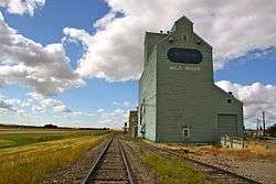 Grain elevators in Milk River | |
| Motto(s): Under Eight Flags | |
 Milk River | |
| Coordinates: 49°9′0″N 112°5′12″W | |
| Country | |
| Province | |
| Region | Southern Alberta |
| Census division | 2 |
| Municipal district | County of Warner No. 5 |
| Incorporated[1] | |
| • Village | July 11, 1916 |
| • Town | February 7, 1956 |
| Government | |
| • Mayor | Peggy Losey |
| • Governing body | Milk River Town Council |
| Area (2016)[3] | |
| • Land | 2.33 km2 (0.90 sq mi) |
| Elevation | 1,059 m (3,474 ft) |
| Population (2016)[3] | |
| • Total | 827 |
| • Density | 355.2/km2 (920/sq mi) |
| Time zone | UTC-7 (MST) |
| Postal code span | T0K 1M0 |
| Highways | Highway 4 Highway 501 |
| Waterway | Milk River |
| GNBC Code | IAJZQ[5] |
| Website | www |
History
The Milk River area was first settled around the beginning of the 20th century. Milk River was incorporated as a village on July 31, 1916, and then a town on March 15, 1956.[6]
The town's motto, "Under Eight Flags", refers to the area having been under the flags of seven governments as well as the Hudson's Bay Company.[6] Including the Hudson's Bay Company's flag (1818–1869), the eight flags are France (1682–1762), the Spanish Empire (1762–1800), the French Republic (1800–1803), the United States (1803–1818), the British Empire (1869–1945), the Canadian Red Ensign (1945–1965), and the current Canadian Maple Leaf (1965–present).[6]
Geography
Climate
The nearest weather station is in Masinasin, Alberta, which is approximately 36 km (22 mi) away.
Milk River has a humid continental climate (Dfb) and enjoys some of the warmest summers in Alberta, along with milder winters.[7]
| Climate data for Masinasin, Alberta | |||||||||||||
|---|---|---|---|---|---|---|---|---|---|---|---|---|---|
| Month | Jan | Feb | Mar | Apr | May | Jun | Jul | Aug | Sep | Oct | Nov | Dec | Year |
| Record high °C (°F) | 17 (63) |
24 (75) |
23 (73) |
31.5 (88.7) |
33.5 (92.3) |
37 (99) |
39 (102) |
41 (106) |
37 (99) |
31 (88) |
24 (75) |
17.5 (63.5) |
41 (106) |
| Average high °C (°F) | −0.5 (31.1) |
2.0 (35.6) |
6.7 (44.1) |
13.8 (56.8) |
19.4 (66.9) |
23.4 (74.1) |
28.3 (82.9) |
27.4 (81.3) |
20.8 (69.4) |
13.9 (57.0) |
4.9 (40.8) |
−0.8 (30.6) |
13.3 (55.9) |
| Daily mean °C (°F) | −6.2 (20.8) |
−4.1 (24.6) |
0.4 (32.7) |
6.6 (43.9) |
11.9 (53.4) |
16.0 (60.8) |
19.7 (67.5) |
18.9 (66.0) |
13.2 (55.8) |
7.1 (44.8) |
−0.9 (30.4) |
−6.6 (20.1) |
6.3 (43.3) |
| Average low °C (°F) | −12.0 (10.4) |
−10.2 (13.6) |
−5.8 (21.6) |
−0.6 (30.9) |
4.3 (39.7) |
8.6 (47.5) |
11.0 (51.8) |
10.3 (50.5) |
5.6 (42.1) |
0.2 (32.4) |
−6.6 (20.1) |
−12.4 (9.7) |
−0.6 (30.9) |
| Record low °C (°F) | −39 (−38) |
−36.5 (−33.7) |
−35 (−31) |
−18.5 (−1.3) |
−6.5 (20.3) |
−1.5 (29.3) |
2 (36) |
−1.5 (29.3) |
−8 (18) |
−27 (−17) |
−34.5 (−30.1) |
−41 (−42) |
−41 (−42) |
| Average precipitation mm (inches) | 20.1 (0.79) |
16.8 (0.66) |
34.5 (1.36) |
33.6 (1.32) |
52.5 (2.07) |
78.3 (3.08) |
32.0 (1.26) |
37.6 (1.48) |
40.5 (1.59) |
23.3 (0.92) |
19.9 (0.78) |
17.5 (0.69) |
407.3 (16.04) |
| Source: 1981-2010 Environment Canada[8] | |||||||||||||
.jpg)
Demographics
In the 2016 Census of Population conducted by Statistics Canada, the Town of Milk River recorded a population of 827 living in 375 of its 420 total private dwellings, a 2% change from its 2011 population of 811. With a land area of 2.33 km2 (0.90 sq mi), it had a population density of 354.9/km2 (919.3/sq mi) in 2016.[3]
In the 2011 Census, the Town of Milk River had a population of 811 living in 357 of its 418 total dwellings, a -0.6% change from its 2006 population of 816. With a land area of 2.39 km2 (0.92 sq mi), it had a population density of 339.3/km2 (878.9/sq mi) in 2011.[9]
The population of the Town of Milk River according to its 2007 municipal census is 846.[10]
Attractions
Recreation venues in Milk River include a nine-hole golf course, curling rink, swimming pool and skateboard park.[11]
Government
The town is governed by a town council composed of a mayor and four councillors. Municipal elections are held every four years.
Infrastructure
The town is connected to two highways: Highway 4, which heads south to Interstate 15 and north to Lethbridge, and Highway 501, which heads west to Cardston and east to Saskatchewan. Air service is provided by Milk River Airport and rail service is offered through Canadian Pacific Railway.
Milk River Health Centre
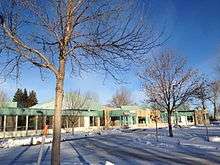
Health services are provided by the Milk River and District Health Centre. The hospital offers 24/7 emergency department services with on call laboratory and diagnostic imaging services. Between 2005 and 2008, the emergency department averaged 1,351 visits per year. The tertiary referral centre for the hospital is Chinook Regional Hospital in Lethbridge.[12][13]
Education
Milk River has two schools – Milk River Elementary School and Erle Rivers High School.[14]
Media
The Milk River Review was a weekly newspaper that was published between November 11, 1948 and May 27, 1954. It continued as a weekly throughout its run as The Review from June 17, 1954 to August 21, 1958, and again under the title of County of Warner Review and Advertiser between September 1, 1958 and March 30, 1961. Finally, the weekly newspaper returned to its original name, running as the Milk River Review from June 1, 1961 through to November 16, 1961.[15]
.jpg)
References
- "Location and History Profile: Town of Milk River" (PDF). Alberta Municipal Affairs. October 7, 2016. p. 400. Retrieved October 16, 2016.
- "Municipal Officials Search". Alberta Municipal Affairs. September 22, 2017. Retrieved September 25, 2017.
- "Population and dwelling counts, for Canada, provinces and territories, and census subdivisions (municipalities), 2016 and 2011 censuses – 100% data (Alberta)". Statistics Canada. February 8, 2017. Retrieved February 8, 2017.
- "Alberta Private Sewage Systems 2009 Standard of Practice Handbook: Appendix A.3 Alberta Design Data (A.3.A. Alberta Climate Design Data by Town)" (PDF) (PDF). Safety Codes Council. January 2012. pp. 212–215 (PDF pages 226–229). Retrieved October 8, 2013.
- "Milk River". Natural Resources Canada. October 6, 2016.
- "Eight Flags Under the Prairie Sun". Town of Milk River Alberta. Milk River. Retrieved 20 November 2013.
- Canada, Environment and Climate Change (2013-09-25). "Canadian Climate Normals 1981-2010 Station Data - Climate - Environment and Climate Change Canada". climate.weather.gc.ca. Retrieved 2020-06-08.
- Environment Canada—. Retrieved 23 July 2017.
- "Population and dwelling counts, for Canada, provinces and territories, and census subdivisions (municipalities), 2011 and 2006 censuses (Alberta)". Statistics Canada. 2012-02-08. Retrieved 2012-02-08.
- Alberta Municipal Affairs (2009-09-15). "Alberta 2009 Official Population List" (PDF). Retrieved 2010-09-14.
- "Recreation Facilities | Town of Milk River". Retrieved 2020-02-03.
- "Archived copy" (PDF). Archived from the original (PDF) on 2014-11-27. Retrieved 2014-11-15.CS1 maint: archived copy as title (link)
- http://www.albertahealthservices.ca/facilities.asp?pid=facility&rid=3316
- "Educational Facilities | Town of Milk River". Retrieved 2020-02-03.
- https://digitallibrary.uleth.ca/digital/collection/sanews/search/searchterm/milk+river+review/field/title/mode/all/conn/and/order/date/ad/asc/cosuppress/1
External links
| Wikimedia Commons has media related to Milk River, Alberta. |
Places adjacent to Milk River, Alberta | |
|---|---|