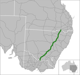
Newell Highway
The Newell Highway is a national highway in New South Wales (NSW), Australia. It provides the major road link between southeastern Queensland and Victoria via central NSW and as such carries large amounts of freight. At 1,058 kilometres (657 mi) in length, the Newell is the longest highway in NSW,[2][3] and passes through fifteen local government areas.[1] The highway is part of Australian national route 39 and was signposted accordingly until 2013. Since then it has been signposted as NSW route A39.
Newell Highway | |
|---|---|
 | |
| General information | |
| Type | Highway |
| Length | 1,058 km (657 mi)[1] |
| Route number(s) |
|
| Former route number |
|
| Major junctions | |
| North end |
|
| |
| South end |
|
| Location(s) | |
| Major settlements | Moree, Narrabri, Coonabarabran, Gilgandra, Dubbo, West Wyalong, Narrandera, Finley |
| Highway system | |
Traffic volumes along the Newell Highway vary from around 1,200 to 4,000 vehicles per day in rural areas. In Dubbo, the largest urban centre through which the highway passes, average daily traffic volumes are in the order of 20,000 vehicles a day. Many heavy vehicles use the Newell Highway – between 26 per cent and 52 per cent of all traffic, depending on the point along the highway.[1] At one point in the Riverina region of NSW, the highway carries approximately 1,900 vehicles daily, of which about 32 per cent is heavy vehicles;[4] while at another point in the north of the state, which carries the largest number of heavy vehicles, on average a truck passes every 60 seconds, 24 hours a day, 7 days a week.[5]
The highway is named in honour of H. H. Newell, the first Commissioner for Main Roads in New South Wales (1932-1941).[6] It carries NSW route A39 signage for its entire length.
Other than short four-lane lengths within some of the urban areas through which it passes, the Newell Highway is a single carriageway, two-lane road, although there are many overtaking lanes, with further overtaking lanes under construction up until 2021 (see Newell Highway Alliance Program" www.rms.nsw.gov.au/projects/newell-highway/program-alliance/index.html)
The speed limit on most rural sections of the highway is 110 km/h (68 mph).[7]
Route
The terrain that the highway traverses is generally flat to gently undulating, with long, straight sections joined by the occasional curved section. However, passing through the Warrumbungle Range, there are steeper grades and tighter curves than on the rest of the highway.[1]
The highway runs generally north-south, parallel to the coast of NSW, about 400 kilometres (250 mi) inland, and is the most direct road link from Victoria to southeastern Queensland, bypassing the more urbanised and congested coastal areas of the state, and in doing so avoiding the difficult coastal topography traversed by the Pacific Highway.
From its northern terminus at Goondiwindi on the Queensland-NSW border, where it meets the Cunningham and Leichhardt Highways, and forms the southward extension of the Cunningham Highway from Warwick and Brisbane, the Newell runs south across the Queensland-New South Wales border through Boggabilla, Moree, Narrabri, Coonabarabran, Gilgandra, Dubbo, Parkes, Forbes, West Wyalong, Narrandera, Jerilderie, and Finley. Its southern terminus is where it crosses the Murray River (part of the border between New South Wales and Victoria) at Tocumwal and meets the Goulburn Valley Highway in Victoria.[7] The Goulburn Valley Highway forms the next section of national route 39 south towards Melbourne via Shepparton and Seymour, where it joins the Hume Highway.
The Newell intersect the following highways:
Bruxner (at Boggabilla), Carnarvon and Gwydir (at Moree), Kamilaroi (at Narrabri), Oxley (east) (north of Coonabarabran), Castlereagh and Oxley (west) (at Gilgandra), Golden and Mitchell (at Dubbo), Mid-Western (east) at Marsden), Mid-Western (west) at West Wyalong), Sturt (at Gillenbah) and Riverina (at Finley).
The Newell Highway is located entirely west of the Great Dividing Range, running largely along the foot of the western slopes of the range, and as such crosses nine major rivers, all west-flowing from the Great Dividing Range. From north to south these rivers are the Macintyre (at Goondiwindi), the Gwydir (10 km north of Moree), the Mehi (at Moree), the Namoi (near Narrabri), the Castlereagh (at Coonabarabran and again at Gilgandra), the Macquarie (at Dubbo), the Lachlan (at Forbes), the Murrumbidgee (at Narrandera), and the Murray (at Tocumwal). Some sections of the Newell Highway are subject to periodic flooding from these rivers,[3] particularly north of Moree,[8] at Dubbo,[9] and south of Narrandera.[10][11]
Naming and numbering
The route now known as the Newell Highway was proclaimed as State Highway 17 in July 1938, and in July 1941 named in honour of H. H. Newell (Commissioner for Main Roads 1932-1941) following his death in office.[7][6] At the time of the gazettal of state highway 17, it followed existing roads as far as possible, but between Coonabarabran and Narrabri and between Narrandera and West Wyalong [2] no road existed. The section through the Pilliga Scrub between Coonabarabran and Narrabri was constructed during 1941-42 as a wartime defence project, and the section between Narrandera and West Wyalong was constructed in 1946-49. In 1952 the ultimate gazetted route of the highway between Narrandera and West Wyalong was altered from its original 1938 gazetted route.
Under the original national road numbering scheme in 1954, national route 39 was to run from the Hume Highway (national route 30, subsequently changed to 31) at Seymour, via Shepparton Tocumwal, Finley, Narrandera, West Wyalong, Forbes, Parkes, Dubbo, Gilgandra, Coonabarabran, Narrabri, Moree, Goondiwindi, Moonie, Miles and Banana to Rockhampton, to connect with the Bruce Highway (national route 1). Consequently the Newell Highway, as part of this route, was signposted in 1965 with the standard black and white national route markers. On 15 January 1993, following the passage of the Australian Land Transport Development Act 1988, the Australian Government assumed financial responsibility from the NSW government for the upkeep and improvement of the Newell Highway. It also assumed responsibility for the onward connectors from either end of the Newell Highway - the Goulburn Valley Highway in Victoria and the Cunningham Highway in Queensland. The black and white national route shields were then replaced with green and gold shields (signifying that the highway is a nationally- rather than state-funded route). These in turn were replaced in 2013 by the alpha-numerical shields of the NSW state-based numbering system.
Some sections of the route of the Newell Highway are shared with the routes of other highways. From north to south these are the Gwydir at Moree, the Kamilaroi at Narrabri, the Oxley (from 10 km north of Coonabarabran to Gilgandra), the Castlereagh through Gilgandra, the Mid-Western between Marsden and West Wyalong, and the Riverina (185 m through Finley).
Route development
Completion of the sealing of the full length of the highway occurred in 1972.
Town centre bypasses have been provided in Moree, Dubbo, Parkes and West Wyalong (heavy vehicle route). A town bypass at Ardlethan has also been constructed.
Major intersections
| State | LGA | Location | km | mi | Destinations | Notes |
|---|---|---|---|---|---|---|
| Queensland | Goondiwindi | Goondiwindi |
| Northern highway terminus at roundabout | ||
| 0 | 0.0 | |||||
| Queensland – New South Wales state border | 1 | 0.62 | Queensland – New South Wales state border | |||
| New South Wales | Macintyre River | 2 | 1.2 | Bridge over river | ||
| Moree Plains | Boggabilla | 8 | 5.0 | |||
| Gwydir River | 122 | 76 | Bridge over river | |||
| Moree Plains | Moree | 131 | 81 | Boggabilla Road | ||
| Mehi River | 133 | 83 | Bridge over river | |||
| Moree Plains | Moree | 133 | 83 | B76 eastern concurrency terminus | ||
| 134 | 83 | B76 western concurrency terminus at roundabout | ||||
| Narrabri | Narrabri | 232 | 144 | |||
| Namoi River | 235 | 146 | Bridge over river | |||
| Narrabri | Narrabri | Roundabout | ||||
| Warrumbungle | Coonabarabran | 348 | 216 | B56 northern concurrency terminus | ||
| Gilgandra | Tooraweenah | 407 | 253 | Tooraweenah–Mendooran Road – Tooraweenah | ||
| Gilgandra | 441 | 274 | B55 eastern concurrency terminus | |||
| Castlereagh River | 442 | 275 | Jack Renshaw Bridge | |||
| Gilgandra | Gilgandra | 442 | 275 | B55 and B56 concurrency termini | ||
| Talbragar River | 501 | 311 | Bridge over river | |||
| Dubbo | Dubbo | 506 | 314 | |||
| Macquarie River | 507 | 315 | Emile Serisier Bridge | |||
| Dubbo | Dubbo | 508 | 316 | |||
| Narromine | Tomingley | 559 | 347 | Tomingley Narromine Road – Narromine | ||
| Parkes | Parkes | 626 | 389 | Condobolin Road west – Condobolin Clarinda Street / Orange Road east – Orange | ||
| Forbes | Forbes | 659 | 409 | Lachlan Valley Way east – Cowra Henry Lawson Way – Grenfell | Lachlan Valley Way northern concurrency terminus | |
| Lake Forbes | 660 | 410 | Oxley Bridge | |||
| Lachlan River | 661 | 411 | Bridge over river | |||
| Forbes | Bundaburrah | 665 | 413 | Lachlan Valley Way west – Condobolin | Lachlan Valley Way southern concurrency terminus | |
| Bland | Marsden | 726 | 451 | Mid-Western Highway eastern concurrency terminus | ||
| Wyalong | 758 | 471 | ||||
| West Wyalong | 763 | 474 | Mid-Western Highway western concurrency terminus | |||
| Coolamon | Mirrool Junction | 813 | 505 | Burley Griffin Way eastern concurrency terminus | ||
| Ardlethan | 831 | 516 | Burley Griffin Way western concurrency terminus | |||
| Narrandera | Grong Grong | 876 | 544 | Ganmain Road – Coolamon | ||
| Narrandera | 898 | 558 | Irrigation Way – Griffith | |||
| Irrigation Canal | 898 | 558 | Bridge over the canal | |||
| Murrumbidgee River | 899 | 559 | Narrandera Bridge | |||
| Narrandera | Gillenbah | 900 | 560 | Sturt Highway south-eastern concurrency terminus | ||
| 901 | 560 | Sturt Highway north-western concurrency terminus | ||||
| Jerilderie | Jerilderie Junction | 991 | 616 | |||
| Billabong Creek | 1,005 | 624 | Bridge over creek | |||
| Jerilderie | Jerilderie | 1,007 | 626 | Conargo Road – Conargo | ||
| Berrigan | Finley | 1,042 | 647 | B58 concurrency terminus | ||
| Murray River | 1,057 | 657 | Edward Hillson Bridge | |||
| New South Wales – Victoria state border | 1,058 | 657 | New South Wales – Victoria state border | |||
| Victoria | Moira | Koonoomoo | Southern highway termninus: continues as Goulburn Valley Highway | |||
1.000 mi = 1.609 km; 1.000 km = 0.621 mi
| ||||||
Gallery
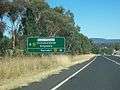 Oxley Highway looking towards the Junction of Newell and Oxley Highways, just east of Coonabarabran, looking south-west.
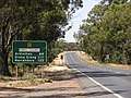 National Route 39, the Newell Highway, in New South Wales, just south of West Wyalong, looking south.
See also
- Highways in Australia
- List of highways in New South Wales
- List of highways in Queensland
- Bland Creek Bridge
References
- "Draft Newell Highway Corridor Strategy" (PDF) (PDF). Roads & Maritime Services, Government of New South Wales. April 2014. pp. 8–9, 11. Retrieved 23 March 2015.
- "Newell Highway: History and Development". OzRoads. Retrieved 22 March 2015.
- "Roads Minister says duplicating Newell Highway is on state government's agenda". ABC News. Australia. 7 May 2014. Retrieved 23 March 2014.
- "Improvements to the Newell Highway at Grong Grong". Projects: South West NSW. Roads & Maritime Services, Government of New South Wales. 2015. Retrieved 22 March 2015.
- Brown, Emma (8 May 2014). "Draft Newell Highway Strategy released". ABC News. Australia. Retrieved 23 March 2014.
- "The Newell Highway – Named after a pioneer road man". Main Roads. OzRoads. 43 (2). December 1977.
- "Newell Highway: State Highway No. 17". OzRoads. Retrieved 22 March 2015.
- "Heavy rain closes roads in NSW north-west". The Sydney Morning Herald. AAP. 28 November 2011. Retrieved 23 March 2015.
- Howe, Marc (12 May 2014). "NSW's Newell Highway Slated for Upgrade". Sourceable. Retrieved 23 March 2015.
- "Travelling? Check road closures here". The Land. 19 March 2012. Retrieved 23 March 2015.
- "Highway flood plan (video)". Prime 7. 31 May 2011. Retrieved 23 March 2015.
External links
- "Draft Newell Highway Corridor Strategy" (PDF) (PDF). Roads & Maritime Services, Government of New South Wales. April 2014.