Mongarlowe River
The Mongarlowe River is a perennial river of the Shoalhaven catchment located in the Southern Tablelands region of New South Wales, Australia.[1]
| Mongarlowe River Little River[1] | |
|---|---|
 | |
| Location | |
| Country | Australia |
| State | New South Wales |
| Region | Sydney Basin (IBRA), Southern Tablelands |
| Local government area | Queanbeyan-Palerang |
| Physical characteristics | |
| Source | Great Dividing Range |
| ⁃ location | southeast of Araluen |
| ⁃ coordinates | 35°39′11″S 149°54′36″E |
| ⁃ elevation | 796 m (2,612 ft) |
| Mouth | Shoalhaven River |
⁃ location | near Charleyong |
⁃ coordinates | 35°14′56″S 149°53′33″E |
⁃ elevation | 556 m (1,824 ft) |
| Length | 72 km (45 mi) |
| Basin features | |
| River system | Shoalhaven River |
| Tributaries | |
| ⁃ left | Northangera Creek, Warrambucca Creek, Tantulean Creek, Cookanulla Creek |
| ⁃ right | Feagans Creek, Nettletons Creek |
| National park | Monga |
| [2] | |
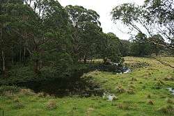
Location and features
The river rises on the western slopes of the Great Dividing Range within the Monga National Park about 6.5 kilometres (4.0 mi) east southeast of the village of Araluen. The river flows generally north, joined by six minor tributaries before reaching its confluence with the Shoalhaven River approximately 3 kilometres (1.9 mi) northwest of the locality of Charleyong. The river descends 242 metres (794 ft) over its 72 kilometres (45 mi) course.[2]
The river is crossed by the Kings Highway northwest of Clyde Mountain.[2]
See also
- List of rivers of New South Wales
- List of rivers in New South Wales (L-Z)
- Monga National Park
- Rivers of New South Wales
References
- "Mongarlowe River". Geographical Names Register (GNR) of NSW. Geographical Names Board of New South Wales. Retrieved 23 May 2013.

- "Map of Mongarlowe River, NSW". Bonzle Digital Atlas of Australia. 2013. Retrieved 23 May 2013.
Rivers of the Southern Rivers catchment, New South Wales, Australia | |
|---|---|
| Illawarra | |
| Shoalhaven | |
| Eurobodalla | |
| Far South Coast | |
| Snowy River | |
| |
This article is issued from Wikipedia. The text is licensed under Creative Commons - Attribution - Sharealike. Additional terms may apply for the media files.