Georges River
The Georges River, also known as Tucoerah River,[1] is an intermediate tide-dominated drowned valley estuary,[5] located to the south and west of Sydney, New South Wales, Australia.
| Georges River Tucoerah River[1] | |
|---|---|
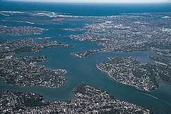 | |
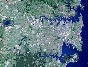 NASA satellite view of Greater Metropolitan Sydney, with the location of the mouth of the Georges River, as marked | |
| Etymology | In honour of King George III[2] |
| Location | |
| Country | Australia |
| State | New South Wales |
| Region | Greater Metropolitan Sydney |
| LGAs | Wollondilly, Campbelltown, Liverpool, Fairfield, Canterbury-Bankstown, Sutherland, Georges River |
| Physical characteristics | |
| Source | Upland swamps, O'Hares Creek |
| ⁃ location | east of Appin, Macarthur region |
| ⁃ coordinates | 34°15′00″S 150°49′48″E |
| ⁃ elevation | 350 m (1,150 ft) |
| Mouth | Botany Bay |
⁃ location | Taren Point |
⁃ coordinates | 34°0′35.994″S 151°7′47.6394″E |
| Length | 96 km (60 mi) |
| Basin size | 930.9 km2 (359.4 sq mi) |
| Basin features | |
| Tributaries | |
| ⁃ left | Bunbury Curran Creek, Cabramatta Creek, Prospect Creek, Salt Pan Creek, Boggywell Creek |
| ⁃ right | Brennan's Creek, O'Hares Creek, Punchbowl Creek, Williams Creek (New South Wales), Deadmans Creek, Mill Creek (New South Wales), Woronora River |
| Lakes and reservoirs | Chipping Norton Lakes |
| [3][4] | |
The source of the Georges River is upland swamps of the O'Hares Creek catchment, approximately 80 kilometres (50 mi) to the south-west of Sydney central business district between the town of Appin and the Illawarra Escarpment. The river travels for approximately 96 kilometres (60 mi) in a north and then easterly direction to its mouth at Botany Bay, about 5 kilometres (3.1 mi) from the Tasman Sea. The Georges River is the main tributary of Botany Bay; with the Cooks River being a secondary tributary.
The total catchment area of the river is approximately 930.9 square kilometres (359.4 sq mi) and the area surrounding the river is managed by various local government authorities and NSW Government agencies.
The land adjacent to the Georges River was occupied for many thousands of years by the Tharawal and Eora peoples. They used the river as an important source of food and a place for trade.
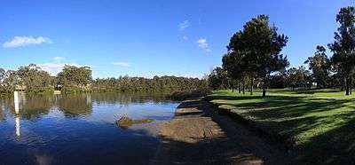
Geography
.JPG)
From its source east of Appin within heath habitat of Wollondilly Shire & Wollongong Local government area, the Georges River flows north through rugged sandstone gorges to the east of Campbelltown, roughly parallel to the Main South railway line, with its eastern bank forming a boundary of Holsworthy Army Base. At Glenfield it reaches the urban environment and then travels to Liverpool where the river turns east and flows past the suburbs of East Hills, Lugarno, and Blakehurst, before emptying into Botany Bay at Taren Point in the southern suburbs of Sydney, where it joins with the estuarine catchment.
Major tributaries include O'Hares Creek, Bunbury Curran Creek, Cabramatta Creek, Prospect Creek, Salt Pan Creek and the Woronora River. The Georges River is popular for recreational activities such as water skiing and swimming. The banks of the river along the lower reaches are marked by large inlets and indentations overlooked by steep sandstone ridges and scarps, many being home to expensive residential properties.
The Georges River features some artificial lakes in the suburb of Chipping Norton, near Liverpool. These lakes, known as the Chipping Norton Lakes, are the result of sand mining and quarrying operations in the twentieth century. The Lakes are now a popular watersports and recreational facility for the residents of the south-western suburbs of Sydney.
Liverpool Weir now forms the uppermost tidal limit and presence of salt water on the Georges River.
Georges River National Park adjoins the upper reaches of the Georges River. From Appin to Glenfield, a large corridor has been protected as part of the Georges River Regional Open Space Corridor. Council reserves allow for access to natural sections of the river at Simmo's Beach,[6] Ingleburn Reserve, Keith Longhurst Reserve,[7] and Frere's Crossing.[8]
Botany Bay Community River Health Monitoring Program is a community-based initiative to monitor ecosystem health catchment.[9]
History
Aboriginal history
Prior to the arrival of Europeans, Georges River was formerly known as Tucoerah River by the traditional custodians of the area.
European history
The Georges River was given its English name in honour of King George III, by Governor Arthur Phillip.[2] It was one of the many sites of the Hawkesbury and Nepean Wars, a series of wars between the Kingdom of Great Britain and the resisting Indigenous clans in the late 1700s and early 1800s.[10]
The river was explored by Bass and Flinders in 1795 on their first voyage on the Tom Thumb after their arrival in New South Wales. The exploration led to the establishment of Bankstown .
A dam was constructed by David Lennox using convict labour at Liverpool in 1836, as a water supply to Liverpool.[11]
In February 2007, Liverpool and Campbelltown City Council were awarded a $2 million grant from the NSW Environmental Trust under their Urban Sustainability Initiative.[12] The grant was to allow the councils, in conjunction with Wollondilly Shire Council and the Georges River Combined Councils Committee, to develop a Comprehensive Strategic Plan focused on the rehabilitation of the catchment area.[13]
Crossings
.png)
Bridges over the Georges River include from east to west:
- Captain Cook Bridge (connecting Sans Souci to Taren Point), for cars, pedestrians and cyclists.
- Tom Uglys Bridge (connecting Blakehurst to Sylvania), for cars, pedestrians and cyclists.
- Old Como railway bridge, now for pedestrians and cyclists.
- Como railway bridge on the Illawarra line, connecting Oatley to Como, for trains.
- Alfords Point Bridge (connecting Padstow Heights to Alfords Point), for cars, pedestrians and cyclists.
- East Hills rail bridge at East Hills, for the Airport & South Line
- Voyager Point footbridge, for pedestrians and cyclists.
- M5 South Western Motorway Georges River East Bridge
- Milperra Bridge (Newbridge Rd connecting Moorebank to Milperra), for cars, pedestrians and cyclists.
- Governor Macquarie Drive bridge (connecting Warwick Farm to Chipping Norton), for cars, pedestrians and cyclists.
- Liverpool Weir - built 1836
- Liverpool footbridge (now demolished which utilised the footing of the decommissioned railway bridge to Holsworthy).[14]
- Newbridge Rd (connecting Liverpool to Chipping Norton), for cars, pedestrians and cyclists.
- M5 South Western Motorway Georges River West Bridge
- Airport & South Line rail bridge (connecting Holsworthy to Glenfield), for trains.
- Cambridge Ave Causeway (connecting Holsworthy to Glenfield), for cars.
- King Falls Bridge [15]
Fish

The Georges River is a popular area for recreational fishing. Species present in the river include bass, bream, whiting, yellowtail, jewfish and flathead. The river is also host to a number of commercial oyster farms. The upper ends of the Georges River are abundant with Bass during the summer months and during the winter months these bass migrate down to the lower ends of the river towards the salt water to breed. Waste water inflows to the river are carefully managed to maintain the estuarine habitat.
See also
- Dharawal National Park
- List of rivers in Australia
- List of rivers in New South Wales (A-K)
- Rivers of New South Wales
- Geography of Sydney
References
- "Georges River". Geographical Names Register (GNR) of NSW. Geographical Names Board of New South Wales. Retrieved 4 January 2013.

- Pollon, Frances, ed. (1990). The Book of Sydney Suburbs. Australia: Angus & Robertson. p. 107. ISBN 0-207-14495-8.
- "Georges River". Estuaries of NSW. Office of Environment and Heritage. 26 April 2012. Retrieved 4 January 2013.
- "Georges River information page". Campbelltown City Council. Archived from the original on 2008-07-30.
- Roy, P. S; Williams, R. J; Jones, A. R; Yassini, I; et al. (2001). "Structure and Function of South-east Australian Estuaries". Estuarine, Coastal and Shelf Science. 53 (3): 351–384. Bibcode:2001ECSS...53..351R. doi:10.1006/ecss.2001.0796.
- "Simmo's Beach Reserve". Macarthur Branch: Activities. National Parks Association of NSW. 2011. Archived from the original on 25 February 2011. Retrieved 4 January 2013.
- "Bushwalkers Basin". Macarthur Branch: Activities. National Parks Association of NSW. 2011. Archived from the original on 26 April 2013. Retrieved 4 January 2013.
- "Freres Crossing". Macarthur Branch: Activities. National Parks Association of NSW. 2011. Archived from the original on 25 February 2011. Retrieved 4 January 2013.
- River Health Monitoring Program Georges Riverkeeper
- Connor, John (2002). The Australian frontier wars, 1788–1838. Sydney: UNSW Press. ISBN 0-86840-756-9.CS1 maint: ref=harv (link)
- "Liverpool Weir". Heritage Branch, New South Wales waling Department of Planning. Retrieved 24 September 2010.
- Project Summaries - 2006 Urban Sustainability Major Program Grants NSW Department of Environment and Climate Change
- "Archived copy". Archived from the original on 2011-06-17. Retrieved 2010-07-20.CS1 maint: archived copy as title (link)
- "Georges River Bridge". Roads and Traffic Authority, New South Wales. Retrieved 20 September 2010.
- "Kings Falls Bridge over Georges River". Roads and Traffic Authority, New South Wales.
External links
- "Georges River catchment" (map). Office of Environment and Heritage. Government of New South Wales.
- "Georges River". Dictionary of Sydney. 2014. Retrieved 27 September 2015. [CC-By-SA] Series of articles about Georges River history
- "Simmos Beach". Dictionary of Sydney. 2008. Retrieved 29 September 2015. [CC-By-SA]
- Catie Gilchrist (2014). "The Cocky Bennett Story". Dictionary of Sydney. Retrieved 2 October 2015. [CC-By-SA]
- Guide to Sydney Rivers site