Interim Biogeographic Regionalisation for Australia
The Interim Biogeographic Regionalisation for Australia (IBRA) is a biogeographic regionalisation of Australia developed by the Australian Government's Department of Sustainability, Environment, Water, Population and Communities. It was developed for use as a planning tool, for example for the establishment of a National Reserve System.
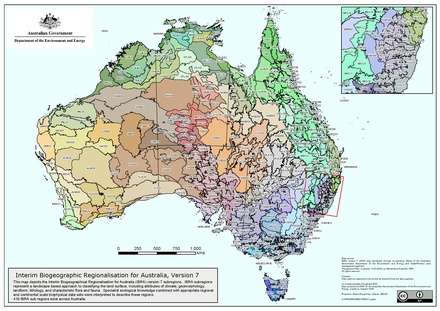
Within the broadest scale, Australia is a major part of the Australasia biogeographic realm, as developed by the World Wide Fund for Nature. Based on this system, the world is also split into 14 terrestrial habitats of which eight are shared by Australia. The Australian land mass is divided into 89 bioregions and 419 subregions. Each region is a land area made up of a group of interacting ecosystems that are repeated in similar form across the landscape.
The most recent version is IBRA7, developed during 2012, which replaced IBRA6.1.
IBRA regions and subregions
This is a list of region and subregions under IBRA7. Region codes are given in parentheses; followed by area, where known. Images of regions are from IBRA6.1, pending creation of maps for IBRA7.

A
| IBRA regions and subregions: IBRA7 | ||||
|---|---|---|---|---|
| IBRA region / subregion | IBRA code | Area | States | Location in Australia |
| Arnhem Coast | ARC | 3,335,669 hectares (8,242,620 acres) | NT |  |
| Murgenella | ARC01 | 113,180 ha (279,700 acres) | ||
| Maningrida | ARC02 | 1,741,376 ha (4,303,030 acres) | ||
| Nhulunbuy | ARC03 | 1,159,659 ha (2,865,580 acres) | ||
| Groote | ARC04 | 268,735 ha (664,060 acres) | ||
| Wessels | ARC05 | 52,720 ha (130,300 acres) | ||
| Arnhem Plateau | ARP | 2,306,023 hectares (5,698,310 acres) | NT |  |
| Alligator | ARP01 | 1,038,621 ha (2,566,490 acres) | ||
| Mainoru | ARP02 | 1,267,401 ha (3,131,820 acres) | ||
| Australian Alps | AUA | 1,232,981 hectares (3,046,760 acres) | NSW, Vic | 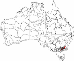 |
| Snowy Mountains | AUA01 | 713,114 ha (1,762,140 acres) | ||
| Victorian Alps | AUA02 | 519,866 ha (1,284,620 acres) | ||
| Avon Wheatbelt | AVW | 9,517,104 hectares (23,517,280 acres) | WA |  |
| Merredin | AVW01 | 6,524,175 ha (16,121,590 acres) | ||
| Katanning | AVW02 | 2,992,929 ha (7,395,690 acres) | ||
B
| IBRA regions and subregions: IBRA7 | ||||
|---|---|---|---|---|
| IBRA region / subregion | IBRA code | Area | States | Location in Australia |
| Ben Lomond | BEL | 657,500 hectares (1,625,000 acres) | Tas |  |
| Ben Lomond (subregion) | BEL01 | |||
| Brigalow Belt North | BBN | 33,790,510 hectares (83,498,200 acres) | Qld |  |
| Townsville Plains | BBN01 | 763,495 ha (1,886,640 acres) | ||
| Bogie River Hills | BBN02 | 1,054,392 ha (2,605,460 acres) | ||
| Cape River Hills | BBN03 | 747,393 ha (1,846,850 acres) | ||
| Beucazon Hills | BBN04 | 95,821 ha (236,780 acres) | ||
| Wyarra Hills | BBN05 | 397,935 ha (983,320 acres) | ||
| Northern Bowen Basin | BBN06 | 1,316,957 ha (3,254,270 acres) | ||
| Belyando Downs | BBN07 | 1,772,127 ha (4,379,020 acres) | ||
| Upper Belyando Floodout | BBN08 | 466,275 ha (1,152,190 acres) | ||
| Anakie Inlier | BBN09 | 382,284 ha (944,640 acres) | ||
| Basalt Downs | BBN10 | 1,274,731 ha (3,149,930 acres) | ||
| Isaac-Comet Downs | BBN11 | 2,693,397 ha (6,655,530 acres) | ||
| Nebo-Connors Ranges | BBN12 | 449,269 ha (1,110,170 acres) | ||
| South Drummond Basin | BBN13 | 1,009,244 ha (2,493,900 acres) | ||
| Marlborough Plains | BBN14 | 1,250,611 ha (3,090,330 acres) | ||
| Brigalow Belt South | BBS | 27,219,776 hectares (67,261,530 acres) | Qld / NSW |  |
| Claude River Downs | BBS01 | 1,026,214 ha (2,535,830 acres) | ||
| Woorabinda | BBS02 | 749,785 ha (1,852,760 acres) | ||
| Boomer Range | BBS03 | 220,541 ha (544,970 acres) | ||
| Mount Morgan Ranges | BBS04 | 1,275,970 ha (3,153,000 acres) | ||
| Callide Creek Downs | BBS05 | 30,133 ha (74,460 acres) | ||
| Arcadia | BBS06 | 715,288 ha (1,767,520 acres) | ||
| Dawson River Downs | BBS07 | 982,807 ha (2,428,570 acres) | ||
| Banana-Auburn Ranges | BBS08 | 1,547,555 ha (3,824,090 acres) | ||
| Buckland Basalts | BBS09 | 281,306 ha (695,120 acres) | ||
| Carnarvon Ranges | BBS10 | 2,263,686 ha (5,593,690 acres) | ||
| Taroom Downs | BBS11 | 652,005 ha (1,611,140 acres) | ||
| Southern Downs | BBS12 | 4,264,666 ha (10,538,220 acres) | ||
| Barakula | BBS13 | 1,301,712 ha (3,216,600 acres) | ||
| Dulacca Downs | BBS14 | 162,442 ha (401,400 acres) | ||
| Weribone High | BBS15 | 966,510 ha (2,388,300 acres) | ||
| Tara Downs | BBS16 | 511,339 ha (1,263,550 acres) | ||
| Eastern Darling Downs | BBS17 | 1,697,945 ha (4,195,710 acres) | ||
| Inglewood Sandstones | BBS18 | 1,219,008 ha (3,012,230 acres) | ||
| Moonie-Commoron Floodout | BBS19 | 750,661 ha (1,854,920 acres) | ||
| Moonie-Barwon Interfluve | BBS20 | 765,231 ha (1,890,930 acres) | ||
| Northern Basalts | BBS21 | 624,671 ha (1,543,600 acres) | ||
| Northern Outwash | BBS22 | 700,241 ha (1,730,330 acres) | ||
| Pilliga Outwash | BBS23 | 535,392 ha (1,322,980 acres) | ||
| Pilliga | BBS24 | 1,732,137 ha (4,280,200 acres) | ||
| Liverpool Plains | BBS25 | 941,752 ha (2,327,120 acres) | ||
| Liverpool Range | BBS26 | 521,960 ha (1,289,800 acres) | ||
| Talbragar Valley | BBS27 | 203,894 ha (503,830 acres) | ||
| Narrandool | BBS28 | 303,754 ha (750,590 acres) | ||
| Broken Hill Complex | BHC | 5,635,422 hectares (13,925,430 acres) | SA / NSW |  |
| Barrier Range | BHC01 | 1,802,996 ha (4,455,300 acres) | ||
| Mootwingee Downs | BHC02 | 630,694 ha (1,558,480 acres) | ||
| Scopes Range | BHC03 | 260,806 ha (644,470 acres) | ||
| Barrier Range Outwash | BHC04 | 1,954,973 ha (4,830,840 acres) | ||
| Bimbowrie | BHC05 | 279,258 ha (690,060 acres) | ||
| Curnamona | BHC06 | 706,696 ha (1,746,280 acres) | ||
| Burt Plain | BRT | 7,379,719 hectares (18,235,680 acres) | NT | 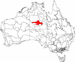 |
| Yuendumu | BRT01 | 2,931,061 ha (7,242,810 acres) | ||
| Atartinga | BRT02 | 3,531,111 ha (8,725,570 acres) | ||
| Mount Chapple | BRT03 | 390,981 ha (966,140 acres) | ||
| Dulcie | BRT04 | 526,567 ha (1,301,180 acres) | ||
C
| IBRA regions and subregions: IBRA7 | ||||
|---|---|---|---|---|
| IBRA region / subregion | IBRA code | Area | States | Location in Australia |
| Cape York Peninsula | CYP | 12,256,457 hectares (30,286,360 acres) | Qld |  |
| Coen - Yambo Inlier | CYP01 | 2,312,126 hectares (5,713,390 acres) | ||
| Starke Coastal Lowlands | CYP02 | 512,498 hectares (1,266,410 acres) | ||
| Cape York - Torres Strait | CYP03 | 94,367 hectares (233,190 acres) | ||
| Jardine - Pascoe Sandstones | CYP04 | 1,444,223 hectares (3,568,750 acres) | ||
| Battle Camp Sandstones | CYP05 | 504,409 hectares (1,246,420 acres) | ||
| Laura Lowlands | CYP06 | 1,791,228 hectares (4,426,220 acres) | ||
| Weipa Plateau | CYP07 | 2,848,753 hectares (7,039,420 acres) | ||
| (Northern) Holroyd Plain | CYP08 | 2,464,074 hectares (6,088,860 acres) | ||
| Coastal Plains | CYP09 | 284,780 hectares (703,700 acres) | ||
| Carnarvon | CAR | 8,430,172 hectares (20,831,410 acres) | WA |  |
| Cape Range | CAR01 | 2,380,498 hectares (5,882,340 acres) | ||
| Wooramel | CAR02 | 6,049,674 hectares (14,949,070 acres) | ||
| Central Arnhem | CEA | 3,462,433 hectares (8,555,860 acres) | NT | 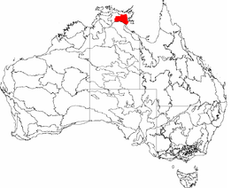 |
| Wilton | CEA01 | 3,137,973 hectares (7,754,100 acres) | ||
| Parson | CEA02 | 324,460 hectares (801,800 acres) | ||
| Central Kimberley | CEK | 7,675,587 hectares (18,966,790 acres) | WA | 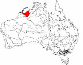 |
| Pentecost | CEK01 | 4,397,260 hectares (10,865,900 acres) | ||
| Hart | CEK02 | 2,324,667 hectares (5,744,380 acres) | ||
| Mount Eliza (Kimberley) | CEK03 | 953,661 hectares (2,356,550 acres) | ||
| Central Mackay Coast | CMC | 1,464,208 hectares (3,618,140 acres) | Qld | 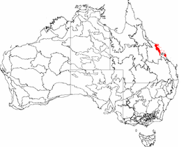 |
| Whitsunday | CMC01 | 89,179 hectares (220,370 acres) | ||
| Proserpine - Sarina Lowlands | CMC02 | 466,498 hectares (1,152,740 acres) | ||
| Clarke - Connors Ranges | CMC03 | 631,985 hectares (1,561,670 acres) | ||
| Byfield | CMC04 | 127,697 hectares (315,550 acres) | ||
| Manifold | CMC05 | 67,885 hectares (167,750 acres) | ||
| Debella | CMC06 | 80,964 hectares (200,070 acres) | ||
| Central Ranges | CER | 10,164,044 hectares (25,115,900 acres) | WA, NT, SA |  |
| Mann-Musgrave Block | CER01 | 9,214,685 hectares (22,769,980 acres) | ||
| Wataru | CER02 | 423,360 hectares (1,046,100 acres) | ||
| Everard Block | CER03 | 525,998 hectares (1,299,770 acres) | ||
| Channel Country | CHC | 30,409,437 hectares (75,143,360 acres) | NT, Qld, NSW, SA | 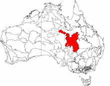 |
| Toko Plains | CHC01 | 2,825,712 hectares (6,982,490 acres) | ||
| Sturt Stony Desert | CHC02 | 8,945,360 hectares (22,104,500 acres) | ||
| Goneaway Tablelands | CHC03 | 5,182,219 hectares (12,805,540 acres) | ||
| Diamantina-Eyre | CHC04 | 1,456,544 hectares (3,599,200 acres) | ||
| Cooper-Diamantina Plains | CHC05 | 4,136,121 hectares (10,220,580 acres) | ||
| Coongie | CHC06 | 1,736,594 hectares (4,291,220 acres) | ||
| Lake Pure | CHC07 | 1,204,027 hectares (2,975,220 acres) | ||
| Noccundra Slopes | CHC08 | 1,798,759 hectares (4,444,830 acres) | ||
| Tibooburra Downs | CHC09 | |||
| Core Ranges | CHC10 | 139,224 hectares (344,030 acres) | ||
| Bulloo | CHC11 | 1,077,480 hectares (2,662,500 acres) | ||
| Bulloo Dunefields | CHC12 | 1,326,712 hectares (3,278,380 acres) | ||
| Central Depression | CHC13 | 580,685 hectares (1,434,900 acres) | ||
| Cobar Peneplain | COP | 7,385,346 hectares (18,249,590 acres) | NSW |  |
| Boorindal Plains | COP1 | 400,236 hectares (989,000 acres) | ||
| Barnato Downs | COP2 | 1,773,542 hectares (4,382,520 acres) | ||
| Canbelego Downs | COP3 | 2,001,425 hectares (4,945,630 acres) | ||
| Nymagee | COP4 | 2,070,061 hectares (5,115,230 acres) | ||
| Lachlan Plains | COP5 | 1,140,082 hectares (2,817,200 acres) | ||
| Coolgardie | COO | 12,912,209 hectares (31,906,760 acres) | WA |  |
| Mardabilla | COO1 | 1,843,125 hectares (4,554,460 acres) | ||
| Southern Cross | COO2 | 6,010,838 hectares (14,853,100 acres) | ||
| Eastern Goldfields | COO3 | 5,058,246 hectares (12,499,200 acres) | ||
| Coral Sea | COS | 17,167 hectares (42,420 acres) | ||
D
| IBRA regions and subregions: IBRA7 | ||||
|---|---|---|---|---|
| IBRA region / subregion | IBRA code | Area | States | Location in Australia |
| Daly Basin | DAB | 2,092,229 hectares (5,170,010 acres) | NT |  |
| Daly Basin | DAB01 | |||
| Dampierland | DAL | 8,360,871 hectares (20,660,160 acres) | WA | 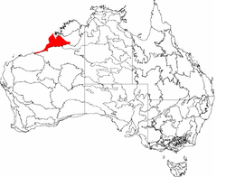 |
| Fitzroy Trough | DAL01 | 3,432,084 hectares (8,480,860 acres) | ||
| Pindanland | DAL02 | 4,928,787 hectares (12,179,300 acres) | ||
| Darling Riverine Plains | DRP | 10,699,769 hectares (26,439,710 acres) | Qld / NSW |  |
| Culgoa-Bokhara | DRP01 | 1,354,799 hectares (3,347,780 acres) | ||
| Warrambool-Moonie | DRP02 | 1,151,637 hectares (2,845,760 acres) | ||
| Castlereagh-Barwon | DRP03 | 4,500,355 hectares (11,120,620 acres) | ||
| Bogan-Macquarie | DRP04 | 1,999,951 hectares (4,941,990 acres) | ||
| Louth Plains | DRP05 | 276,573 hectares (683,430 acres) | ||
| Wilcannia Plains | DRP06 | 504,562 hectares (1,246,800 acres) | ||
| Menindee | DRP07 | 653,935 hectares (1,615,910 acres) | ||
| Great Darling Anabranch | DRP08 | 147,138 hectares (363,590 acres) | ||
| Pooncarie-Darling | DRP09 | 110,819 hectares (273,840 acres) | ||
| Darwin Coastal | DAC | 2,843,199 hectares (7,025,700 acres) | NT | 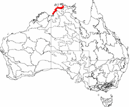 |
| Darwin Coastal | DAC01 | |||
| Davenport Murchison Ranges | DMR | 5,805,108 hectares (14,344,730 acres) | NT | 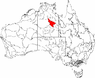 |
| Ashburton Range | DMR01 | 1,218,621 hectares (3,011,280 acres) | ||
| Davenport | DMR02 | 1,589,590 hectares (3,928,000 acres) | ||
| Barkly | DMR03 | 2,996,897 hectares (7,405,490 acres) | ||
| Desert Uplands | DEU | 6,941,095 hectares (17,151,820 acres) | Qld | 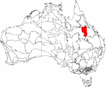 |
| Prairie-Torrens Creeks Alluvials | DEU01 | 1,580,384 hectares (3,905,210 acres) | ||
| Alice Tableland | DEU02 | 2,866,760 hectares (7,083,900 acres) | ||
| Cape-Campaspe Plains | DEU03 | 1,007,026 hectares (2,488,420 acres) | ||
| Jericho | DEU04 | 1,486,926 hectares (3,674,270 acres) | ||
E
| IBRA regions and subregions: IBRA7 | ||||
|---|---|---|---|---|
| IBRA region / subregion | IBRA code | Area | States | Location in Australia |
| Einasleigh Uplands | EIU | 11,625,726 hectares (28,727,790 acres) | Qld | 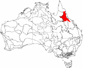 |
| Georgetown - Croydon | EIU01 | 1,041,407 hectares (2,573,370 acres) | ||
| Kidston | EIU02 | 2,929,528 hectares (7,239,020 acres) | ||
| Hodgkinson Basin | EIU03 | 1,607,221 hectares (3,971,530 acres) | ||
| Broken River | EIU04 | 3,309,590 hectares (8,178,200 acres) | ||
| Undara - Toomba Basalts | EIU05 | 2,076,208 hectares (5,130,420 acres) | ||
| Herberton - Wairuna | EIU06 | 661,771 hectares (1,635,270 acres) | ||
| Esperance Plains | ESP | 2,921,327 hectares (7,218,760 acres) | WA |  |
| Fitzgerald | ESP01 | 1,577,938 hectares (3,899,170 acres) | ||
| Recherche | ESP02 | 1,343,390 hectares (3,319,600 acres) | ||
| Eyre Yorke Block | EYB | 6,120,409 hectares (15,123,860 acres) | SA |  |
| Southern Yorke | EYB01 | 438,470 hectares (1,083,500 acres) | ||
| St Vincent | EYB02 | 1,093,789 hectares (2,702,810 acres) | ||
| Eyre Hills | EYB03 | 1,172,576 hectares (2,897,500 acres) | ||
| Talia | EYB04 | 1,096,175 hectares (2,708,710 acres) | ||
| Eyre Mallee | EYB05 | 2,319,398 hectares (5,731,360 acres) | ||
F
| IBRA regions and subregions: IBRA7 | ||||
|---|---|---|---|---|
| IBRA region / subregion | IBRA code | Area | States | Location in Australia |
| Finke | FIN | 7,267,416 hectares (17,958,180 acres) | NT / SA |  |
| Henbury | FIN01 | 2,257,063 hectares (5,577,320 acres) | ||
| Finke River | FIN02 | 1,601,516 hectares (3,957,430 acres) | ||
| Tieyon | FIN03 | 2,505,610 hectares (6,191,500 acres) | ||
| Pedirka | FIN04 | 903,228 hectares (2,231,920 acres) | ||
| Flinders Lofty Block | FLB | 6,615,765 hectares (16,347,910 acres) | SA / NSW |  |
| Mount Lofty Ranges | FLB01 | 300,580 hectares (742,700 acres) | ||
| Broughton | FLB02 | 1,032,918 hectares (2,552,400 acres) | ||
| Olary Spur | FLB02 | 1,745,479 hectares (4,313,170 acres) | ||
| Southern Flinders | FLB04 | 728,317 hectares (1,799,710 acres) | ||
| Northern Flinders | FLB05 | 1,846,804 hectares (4,563,550 acres) | ||
| Central Flinders | FLB06 | 961,667 hectares (2,376,330 acres) | ||
| Furneaux | FUR | 537,543 hectares (1,328,300 acres) | Tas / Vic | |
| Wilsons Promontory | FUR01 | 41,144 hectares (101,670 acres) | ||
| Flinders | FUR02 | 496,398 hectares (1,226,630 acres) | ||
G
| IBRA regions and subregions: IBRA7 | ||||
|---|---|---|---|---|
| IBRA region / subregion | IBRA code | Area | States | Location in Australia |
| Gascoyne | GAS | 18,075,257 hectares (44,664,930 acres) | WA | 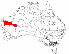 |
| Ashburton | GAS01 | 3,687,030 hectares (9,110,800 acres) | ||
| Carnegie | GAS02 | 4,718,656 hectares (11,660,050 acres) | ||
| Augustus | GAS03 | 9,669,571 hectares (23,894,030 acres) | ||
| Gawler | GAW | 12,002,883 hectares (29,659,770 acres) | SA |  |
| Myall Plains | GAW01 | 1,088,767 hectares (2,690,400 acres) | ||
| Gawler Volcanics | GAW02 | 1,556,182 hectares (3,845,410 acres) | ||
| Gawler Lakes | GAW03 | 2,049,193 hectares (5,063,670 acres) | ||
| Arcoona Plateau | GAW04 | 1,089,865 hectares (2,693,120 acres) | ||
| Kingoonya | GAW05 | 1,922,414 hectares (4,750,390 acres) | ||
| Torrens | GAW06 | 1,439,093 hectares (3,556,080 acres) | ||
| Roxby | GAW07 | 1,409,305 hectares (3,482,470 acres) | ||
| Commonwealth Hill | GAW08 | 1,448,062 hectares (3,578,240 acres) | ||
| Geraldton Sandplains | GES | 3,142,149 hectares (7,764,420 acres) | WA |  |
| Geraldton Hills | GES01 | 1,969,997 hectares (4,867,970 acres) | ||
| Leseur Sandplain | GES02 | 1,172,152 hectares (2,896,450 acres) | ||
| Gibson Desert | GID | 15,628,918 hectares (38,619,900 acres) | WA | 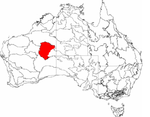 |
| Lateritic Plain | GID01 | 12,714,805 hectares (31,418,970 acres) | ||
| Dune Field | GID02 | 2,914,114 hectares (7,200,930 acres) | ||
| Great Sandy Desert | GSD | 39,486,135 hectares (97,572,360 acres) | NT / WA | 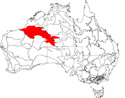 |
| McLarty | GSD01 | 12,316,754 hectares (30,435,360 acres) | ||
| Mackay | GSD02 | 25,698,395 hectares (63,502,120 acres) | ||
| Ehrenberg | GSD03 | 375,668 hectares (928,300 acres) | ||
| Amedeus | GSD04 | 722,845 hectares (1,786,190 acres) | ||
| Lake Bennett | GSD05 | 289,541 hectares (715,470 acres) | ||
| Lake Lewis | GSD06 | 82,932 hectares (204,930 acres) | ||
| Great Victoria Desert | GVD | 42,246,564 hectares (104,393,530 acres) | SA / WA | 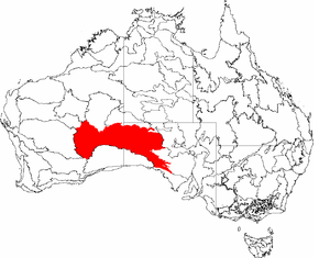 |
| Shield | GVD01 | 4,741,854 hectares (11,717,380 acres) | ||
| Central | GVD02 | 12,590,867 hectares (31,112,710 acres) | ||
| Maralinga | GVD03 | 11,460,762 hectares (28,320,160 acres) | ||
| Kintore | GVD04 | 4,961,542 hectares (12,260,240 acres) | ||
| Tallaringa | GVD05 | 3,663,149 hectares (9,051,840 acres) | ||
| Yellabinna | GVD06 | 4,828,389 hectares (11,931,210 acres) | ||
| Gulf Coastal | GUC | 2,711,718 hectares (6,700,800 acres) | NT |  |
| Limmen | GUC01 | 12,714,805 hectares (31,418,970 acres) | ||
| Pellews | GUC02 | 2,914,114 hectares (7,200,930 acres) | ||
| Gulf Fall and Uplands | GFU | 11,847,909 hectares (29,276,820 acres) | NT / Qld |  |
| McArthur | GFU01 | 9,330,938 hectares (23,057,250 acres) | ||
| Nicholson | GFU02 | 2,516,971 hectares (6,219,570 acres) | ||
| Gulf Plains | GUP | 22,041,825 hectares (54,466,540 acres) | NT / Qld | 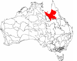 |
| Karumba Plains | GUP01 | 1,057,366 hectares (2,612,810 acres) | ||
| Armraynald Plains | GUP02 | 1,589,437 hectares (3,927,580 acres) | ||
| Woondoola Plains | GUP03 | 2,375,110 hectares (5,869,000 acres) | ||
| Mitchell-Gilbert Fans | GUP04 | 5,262,816 hectares (13,004,700 acres) | ||
| Claraville Plains | GUP05 | 3,738,013 hectares (9,236,830 acres) | ||
| Holroyd Plain-Red Plateau | GUP06 | 2,208,468 hectares (5,457,240 acres) | ||
| Doomadgee Plains | GUP07 | 1,831,823 hectares (4,526,530 acres) | ||
| Donors Plateau | GUP08 | 2,449,964 hectares (6,053,990 acres) | ||
| Gilberton Plateau | GUP09 | 1,403,937 hectares (3,469,200 acres) | ||
| Wellesley Islands | GUP10 | 124,893 hectares (308,620 acres) | ||
H
| IBRA regions and subregions: IBRA7 | ||||
|---|---|---|---|---|
| IBRA region / subregion | IBRA code | Area | States | Location in Australia |
| Hampton | HAM | 1,088,198 hectares (2,689,000 acres) | WA | 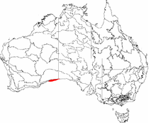 |
| Hampton | HAM01 | |||
I
| IBRA regions and subregions: IBRA7 | ||||
|---|---|---|---|---|
| IBRA region / subregion | IBRA code | Area | States | Location in Australia |
| Indian Tropical Islands | ITI | 27,329 hectares (67,530 acres) | ||
| Christmas Island | ITI01 | 13,664 hectares (33,760 acres) | ||
| Cocos Islands | ITI02 | 1,463 hectares (3,620 acres) | ||
| Timor Sea Coral Islands | ITI03 | 12,203 hectares (30,150 acres) | ||
J
| IBRA regions and subregions: IBRA7 | ||||
|---|---|---|---|---|
| IBRA region / subregion | IBRA code | Area | States | Location in Australia |
| Jarrah Forest | JAF | 4,509,074 hectares (11,142,160 acres) | WA |  |
| Northern Jarrah Forest | JAF01 | 1,898,799 hectares (4,692,030 acres) | ||
| Southern Jarrah Forest | JAF02 | 2,610,275 hectares (6,450,130 acres) | ||
K
| IBRA regions and subregions: IBRA7 | ||||
|---|---|---|---|---|
| IBRA region / subregion | IBRA code | Area | States | Location in Australia |
| Kanmantoo | KAN | 812,415 hectares (2,007,520 acres) | SA |  |
| Kangaroo Island | KAN01 | 441,685 hectares (1,091,430 acres) | ||
| Fleurieu | KAN02 | 370,730 hectares (916,100 acres) | ||
| King | KIN | 425,567 hectares (1,051,600 acres) | Tas | 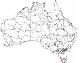 |
| King | KIN01 | |||
L
| IBRA regions and subregions: IBRA7 | ||||
|---|---|---|---|---|
| IBRA region / subregion | IBRA code | Area | States | Location in Australia |
| Little Sandy Desert | LSD | 11,089,857 hectares (27,403,630 acres) | WA | 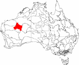 |
| Rudall | LSD01 | 991,277 hectares (2,449,500 acres) | ||
| Trainor | LSD02 | 10,098,580 hectares (24,954,100 acres) | ||
M
| IBRA regions and subregions: IBRA7 | ||||
|---|---|---|---|---|
| IBRA region / subregion | IBRA code | Area | States | Location in Australia |
| MacDonnell Ranges | MAC | 3,929,444 hectares (9,709,870 acres) | NT |  |
| McDonnell | MAC01 | 1,483,959 hectares (3,666,940 acres) | ||
| Watarrka | MAC02 | 1,092,782 hectares (2,700,320 acres) | ||
| Hartz Range | MAC03 | 1,352,702 hectares (3,342,600 acres) | ||
| Mallee | MAL | 7,397,559 hectares (18,279,770 acres) | WA |  |
| Eastern Mallee | MAL01 | 3,415,839 hectares (8,440,720 acres) | ||
| Western Mallee | MAL02 | 3,981,720 hectares (9,839,000 acres) | ||
| Mitchell Grass Downs | MGD | 33,468,761 hectares (82,703,110 acres) | NT / Qld | 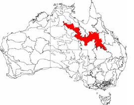 |
| Sylvester | MGD01 | 1,153,283 hectares (2,849,820 acres) | ||
| Barkly Tableland | MGD02 | 9,479,612 hectares (23,424,630 acres) | ||
| Georgina Limestone | MGD03 | 2,292,026 hectares (5,663,720 acres) | ||
| Southwestern Downs | MGD04 | 3,715,454 hectares (9,181,090 acres) | ||
| Kynuna Plateau | MGD05 | 2,293,311 hectares (5,666,890 acres) | ||
| Northern Downs | MGD06 | 435,263 hectares (1,075,560 acres) | ||
| Central Downs | MGD07 | 9,378,817 hectares (23,175,560 acres) | ||
| Southern Wooded Downs | MGD08 | 4,720,995 hectares (11,665,830 acres) | ||
| Mount Isa Inlier | MII | 6,778,263 hectares (16,749,450 acres) | Qld |  |
| Southwestern Plateaus and Floodouts | MII01 | 1,333,519 hectares (3,295,200 acres) | ||
| Thorntonia | MII02 | 802,892 hectares (1,983,990 acres) | ||
| Mount Isa | MII03 | 4,641,851 hectares (11,470,260 acres) | ||
| Mulga Lands | MUL | 25,188,333 hectares (62,241,730 acres) | NSW / Qld |  |
| West Balonne Plains | MUL01 | 1,991,194 hectares (4,920,350 acres) | ||
| Eastern Mulga Plains | MUL02 | 1,563,269 hectares (3,862,920 acres) | ||
| Nebine Plains, Block Range | MUL03 | 1,898,731 hectares (4,691,870 acres) | ||
| North Eastern Plains | MUL04 | 660,369 hectares (1,631,810 acres) | ||
| Warrego Plains | MUL05 | 2,492,085 hectares (6,158,080 acres) | ||
| Langlo Plains | MUL06 | 1,290,484 hectares (3,188,860 acres) | ||
| Cuttaburra-Paroo | MUL07 | 1,703,985 hectares (4,210,640 acres) | ||
| West Warrego | MUL08 | 4,790,087 hectares (11,836,560 acres) | ||
| Northern Uplands | MUL09 | 1,147,549 hectares (2,835,660 acres) | ||
| West Bulloo | MUL10 | 2,852,104 hectares (7,047,700 acres) | ||
| Urisino Sandplains | MUL11 | 2,007,350 hectares (4,960,300 acres) | ||
| Warrego Sands | MUL12 | 479,471 hectares (1,184,800 acres) | ||
| Kerribree Basin | MUL13 | 399,576 hectares (987,370 acres) | ||
| White Cliffs Plateau | MUL14 | 1,074,309 hectares (2,654,680 acres) | ||
| Paroo Overflow | MUL15 | 301,217 hectares (744,320 acres) | ||
| Paroo-Darling Sands | MUL16 | 536,556 hectares (1,325,860 acres) | ||
| Murchison | MUR | 28,120,554 hectares (69,487,400 acres) | WA |  |
| Eastern Murchison | MUR01 | 21,135,040 hectares (52,225,800 acres) | ||
| Western Murchison | MUR02 | 6,985,514 hectares (17,261,580 acres) | ||
| Murray Darling Depression | MDD | 19,958,349 hectares (49,318,150 acres) | NSW, SA, Vic |  |
| South Olary Plain | MDD01 | 5,439,224 hectares (13,440,620 acres) | ||
| Murray Mallee | MDD02 | 5,037,583 hectares (12,448,140 acres) | ||
| Murray Lakes and Coorong | MDD03 | 249,191 hectares (615,760 acres) | ||
| Lowan Mallee | MDD04 | 2,391,719 hectares (5,910,070 acres) | ||
| Wimmera | MDD05 | 2,145,380 hectares (5,301,300 acres) | ||
| Darling Depression | MDD06 | 3,662,438 hectares (9,050,080 acres) | ||
| Braemer | MDD07 | 1,032,815 hectares (2,552,140 acres) | ||
N
| IBRA regions and subregions: IBRA7 | ||||
|---|---|---|---|---|
| IBRA region / subregion | IBRA code | Area | States | Location in Australia |
| Nandewar | NAN | 2,701,977 hectares (6,676,730 acres) | NSW / Qld |  |
| Nandewar Northern Complex | NAN01 | 962,254 hectares (2,377,780 acres) | ||
| Inverell Basalts | NAN02 | 230,854 hectares (570,450 acres) | ||
| Kaputar | NAN03 | 78,307 hectares (193,500 acres) | ||
| Peel | NAN04 | 1,430,562 hectares (3,535,000 acres) | ||
| Naracoorte Coastal Plain | NCP | 2,458,215 hectares (6,074,380 acres) | SA / Vic |  |
| Bridgewater | NCP01 | 463,723 hectares (1,145,880 acres) | ||
| Glenelg Plain | NCP02 | 554,775 hectares (1,370,880 acres) | ||
| Lucindale | NCP03 | 731,656 hectares (1,807,960 acres) | ||
| Tintinara | NCP04 | 708,061 hectares (1,749,660 acres) | ||
| New England Tablelands | NET | 3,002,213 hectares (7,418,630 acres) | NSW |  |
| Bundarra Downs | NET01 | 151,867 hectares (375,270 acres) | ||
| Beardy River Hills | NET02 | 24,625 hectares (60,850 acres) | ||
| Walcha Plateau | NET03 | 473,825 hectares (1,170,850 acres) | ||
| Armidale Plateau | NET04 | 290,577 hectares (718,030 acres) | ||
| Wongwibinda Plateau | NET05 | 106,929 hectares (264,230 acres) | ||
| Deepwater Downs | NET06 | 97,773 hectares (241,600 acres) | ||
| Glenn Innes-Guyra Basalts | NET07 | 277,299 hectares (685,220 acres) | ||
| Ebor Basalts | NET08 | 35,709 hectares (88,240 acres) | ||
| Moredun Volcanics | NET09 | 117,461 hectares (290,250 acres) | ||
| Severn River Volcanics | NET10 | 150,795 hectares (372,620 acres) | ||
| Northeast Forest Lands | NET11 | 206,492 hectares (510,250 acres) | ||
| Tenterfield Plateau | NET12 | 139,242 hectares (344,070 acres) | ||
| Yarrowyck-Kentucky Downs | NET13 | 65,135 hectares (160,950 acres) | ||
| Binghi Plateau | NET14 | 64,555 hectares (159,520 acres) | ||
| Stanthorpe Plateau | NET15 | 267,999 hectares (662,240 acres) | ||
| Eastern Nandewars | NET16 | 319,096 hectares (788,500 acres) | ||
| Tingha Plateau | NET17 | 78,461 hectares (193,880 acres) | ||
| Nightcap | NET18 | 113,767 hectares (281,120 acres) | ||
| Round Mountain | NET19 | 20,606 hectares (50,920 acres) | ||
| Northern Kimberley | NOK | 8,420,100 hectares (20,807,000 acres) | WA | 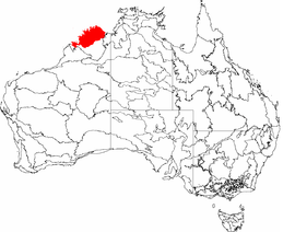 |
| Mitchell | NOK01 | 5,970,915 hectares (14,754,450 acres) | ||
| Berkeley | NOK02 | 2,449,185 hectares (6,052,070 acres) | ||
| NSW North Coast | NNC | 3,996,591 hectares (9,875,790 acres) | NSW |  |
| Washpool | NNC01 | 59,377 hectares (146,720 acres) | ||
| Cataract | NNC02 | 121,338 hectares (299,830 acres) | ||
| Dalmorton | NNC03 | 316,458 hectares (781,980 acres) | ||
| Chaelundi | NNC04 | 188,279 hectares (465,250 acres) | ||
| Yuraygir | NNC05 | 45,815 hectares (113,210 acres) | ||
| Coffs Coast and Escarpment | NNC06 | 308,115 hectares (761,370 acres) | ||
| Macleay Hastings | NNC07 | 729,170 hectares (1,801,800 acres) | ||
| Carrai Plateau | NNC08 | 20,100 hectares (50,000 acres) | ||
| Macleay Gorges | NNC09 | 153,349 hectares (378,930 acres) | ||
| Upper Manning | NNC10 | 83,181 hectares (205,540 acres) | ||
| Comboyne Plateau | NNC11 | 123,315 hectares (304,720 acres) | ||
| Mummel Escarpment | NNC12 | 400,916 hectares (990,690 acres) | ||
| Barrington | NNC13 | 110,903 hectares (274,050 acres) | ||
| Tomalla | NNC14 | 227,615 hectares (562,450 acres) | ||
| Ellerston | NNC15 | 113,183 hectares (279,680 acres) | ||
| Upper Hunter | NNC16 | 232,750 hectares (575,100 acres) | ||
| Karuah Manning | NNC17 | 602,423 hectares (1,488,620 acres) | ||
| Rocky River Gorge | NNC18 | 86,829 hectares (214,560 acres) | ||
| Guy Fawkes | NNC19 | 73,477 hectares (181,570 acres) | ||
| NSW South Western Slopes | NSS | 8,681,126 hectares (21,451,530 acres) | NSW / Vic | 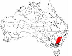 |
| Inland Slopes | NSS01 | 4,640,857 hectares (11,467,810 acres) | ||
| Lower Slopes | NSS02 | 3,938,809 hectares (9,733,010 acres) | ||
| Capertee Valley | NSS03 | 101,460 hectares (250,700 acres) | ||
| Nullarbor | NUL | 19,722,774 hectares (48,736,040 acres) | SA / WA | 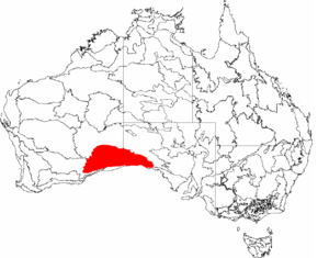 |
| Carlisle | NUL01 | 5,788,547 hectares (14,303,810 acres) | ||
| Nullarbor Plain | NUL02 | 12,785,260 hectares (31,593,100 acres) | ||
| Yalata | NUL03 | 1,148,966 hectares (2,839,160 acres) | ||
O
| IBRA regions and subregions: IBRA7 | ||||
|---|---|---|---|---|
| IBRA region / subregion | IBRA code | Area | States | Location in Australia |
| Ord Victoria Plain | OVP | 12,540,703 hectares (30,988,750 acres) | NT / WA |  |
| Purnululu | OVP01 | 3,233,873 hectares (7,991,070 acres) | ||
| South Kimberley Interzone | OVP02 | 7,728,296 hectares (19,097,040 acres) | ||
| Gregory | OVP03 | 74,982 hectares (185,280 acres) | ||
| Camfield | OVP04 | 828,712 hectares (2,047,790 acres) | ||
P
| IBRA regions and subregions: IBRA7 | ||||
|---|---|---|---|---|
| IBRA region / subregion | IBRA code | Area | States | Location in Australia |
| Pacific Subtropical Islands | PSI | 5,817 hectares (14,370 acres) | ||
| Lord Howe Island | PSI01 | 1,909 hectares (4,720 acres) | ||
| Norfolk Island | PSI02 | 3,908 hectares (9,660 acres) | ||
| Pine Creek | PCK | 2,851,777 hectares (7,046,890 acres) | NT |  |
| Pine Creek | PCK01 | |||
| Pilbara | PIL | 17,823,126 hectares (44,041,900 acres) | WA | 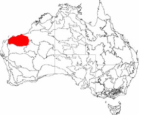 |
| Chichester | PIL01 | 8,374,728 hectares (20,694,400 acres) | ||
| Fortescue | PIL02 | 1,951,435 hectares (4,822,100 acres) | ||
| Hamersley | PIL03 | 5,634,727 hectares (13,923,710 acres) | ||
| Roebourne | PIL04 | 1,862,236 hectares (4,601,690 acres) | ||
R
| IBRA regions and subregions: IBRA7 | ||||
|---|---|---|---|---|
| IBRA region / subregion | IBRA code | Area | States | Location in Australia |
| Riverina | RIV | 9,704,469 hectares (23,980,270 acres) | NSW, SA, Vic | 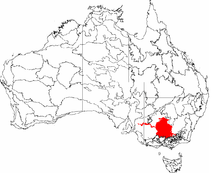 |
| Lachlan | RIV01 | 2,377,523 hectares (5,874,990 acres) | ||
| Murrumbidgee | RIV02 | 2,946,813 hectares (7,281,730 acres) | ||
| Murray Fans | RIV03 | 1,952,238 hectares (4,824,090 acres) | ||
| Victorian Riverina | RIV04 | 1,890,627 hectares (4,671,840 acres) | ||
| Robinvale Plains | RIV05 | 162,003 hectares (400,320 acres) | ||
| Murray Scroll Belt | RIV06 | 375,266 hectares (927,300 acres) | ||
S
| IBRA regions and subregions: IBRA7 | ||||
|---|---|---|---|---|
| IBRA region / subregion | IBRA code | Area | States | Location in Australia |
| Simpson Strzelecki Dunefields | SSD | 27,984,283 hectares (69,150,670 acres) | NSW, NT, Qld, SA | 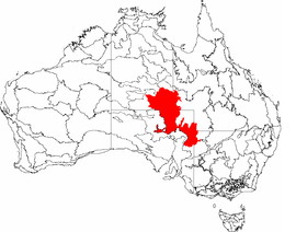 |
| Andado | SSD01 | 1,355,195 hectares (3,348,760 acres) | ||
| Simpson Desert | SSD02 | 12,962,073 hectares (32,029,980 acres) | ||
| Dieri | SSD03 | 5,152,029 hectares (12,730,940 acres) | ||
| Warriner | SSD04 | 1,032,165 hectares (2,550,540 acres) | ||
| Strzelecki Desert | SSD05 | 7,482,821 hectares (18,490,450 acres) | ||
| South East Coastal Plain | SCP | 1,749,237 hectares (4,322,460 acres) | Vic |  |
| Gippsland Plain | SCP01 | 1,246,995 hectares (3,081,390 acres) | ||
| Otway Plain | SCP02 | 237,799 hectares (587,610 acres) | ||
| Warrnambool Plain | SCP03 | 264,443 hectares (653,450 acres) | ||
| South East Corner | SEC | 2,532,053 hectares (6,256,840 acres) | NSW / Vic | 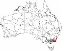 |
| East Gippsland Lowlands | SEC01 | 623,515 hectares (1,540,740 acres) | ||
| South East Coastal Ranges | SEC02 | 1,734,517 hectares (4,286,080 acres) | ||
| Bateman | SEC03 | 174,020 hectares (430,000 acres) | ||
| South Eastern Highlands | SEH | 8,375,961 hectares (20,697,450 acres) | ACT, NSW, Vic |  |
| Highlands-Southern Fall | SEH01 | 1,196,334 hectares (2,956,210 acres) | ||
| Highlands-Northern Fall | SEH02 | 1,415,806 hectares (3,498,530 acres) | ||
| Otway Ranges | SEH03 | 149,857 hectares (370,300 acres) | ||
| Strzelecki Ranges | SEH04 | 342,045 hectares (845,210 acres) | ||
| Murrumbateman | SEH06 | 630,454 hectares (1,557,890 acres) | ||
| Bungonia | SEH07 | 431,185 hectares (1,065,480 acres) | ||
| Kanangra | SEH08 | 131,310 hectares (324,500 acres) | ||
| Crookwell | SEH09 | 466,523 hectares (1,152,800 acres) | ||
| Oberon | SEH10 | 293,164 hectares (724,420 acres) | ||
| Bathurst | SEH11 | 161,486 hectares (399,040 acres) | ||
| Orange | SEH12 | 284,172 hectares (702,200 acres) | ||
| Hill End | SEH13 | 504,377 hectares (1,246,340 acres) | ||
| Bondo | SEH14 | 541,990 hectares (1,339,300 acres) | ||
| Kybeyan-Gourock | SEH15 | 479,221 hectares (1,184,180 acres) | ||
| Monaro | SEH16 | 1,267,543 hectares (3,132,170 acres) | ||
| Capertee Uplands | SEH17 | 80,494 hectares (198,910 acres) | ||
| South East Queensland | SEQ | 7,804,921 hectares (19,286,380 acres) | NSW / Qld |  |
| Burnett-Curtis Hills and Ranges | SEQ01 | 962,583 hectares (2,378,590 acres) | ||
| Moreton Basin | SEQ02 | 784,969 hectares (1,939,700 acres) | ||
| Burringbar-Conondale Ranges | SEQ03 | 630,616 hectares (1,558,290 acres) | ||
| Sunshine Coast-Gold Coast Lowlands | SEQ04 | 351,123 hectares (867,640 acres) | ||
| Brisbane-Barambah Volcanics | SEQ05 | 806,778 hectares (1,993,590 acres) | ||
| South Burnett | SEQ06 | 563,866 hectares (1,393,340 acres) | ||
| Gympie Block | SEQ07 | 859,020 hectares (2,122,700 acres) | ||
| Burnett-Curtis Coastal Lowlands | SEQ08 | 700,181 hectares (1,730,180 acres) | ||
| Great Sandy | SEQ09 | 356,502 hectares (880,940 acres) | ||
| Scenic Rim | SEQ10 | 614,729 hectares (1,519,030 acres) | ||
| Woodenbong | SEQ11 | 325,603 hectares (804,580 acres) | ||
| Clarence Sandstones | SEQ12 | 327,829 hectares (810,080 acres) | ||
| Clarence Lowlands | SEQ13 | 520,901 hectares (1,287,170 acres) | ||
| Southern Volcanic Plain | SVP | 2,440,340 hectares (6,030,200 acres) | SA / Vic | |
| Victorian Volcanic Plain | SVP01 | 2,356,147 hectares (5,822,170 acres) | ||
| Mount Gambier | SVP02 | 84,194 hectares (208,050 acres) | ||
| Stony Plains | STP | 13,166,372 hectares (32,534,810 acres) | SA |  |
| Breakaways | STP01 | 2,444,385 hectares (6,040,210 acres) | ||
| Oodnadatta | STP02 | 2,593,717 hectares (6,409,210 acres) | ||
| Murnpeowie | STP03 | 2,910,385 hectares (7,191,720 acres) | ||
| Peake-Dennison Inlier | STP04 | 158,623 hectares (391,970 acres) | ||
| Macumba | STP05 | 693,282 hectares (1,713,140 acres) | ||
| Witjira | STP06 | 1,677,111 hectares (4,144,230 acres) | ||
| Baltana | STP07 | 2,688,870 hectares (6,644,300 acres) | ||
| Sturt Plateau | STU | 9,857,531 hectares (24,358,490 acres) | NT | 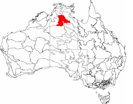 |
| Renehan | STU01 | 1,938,959 hectares (4,791,270 acres) | ||
| Newcastle | STU02 | 4,333,836 hectares (10,709,140 acres) | ||
| Birdum | STU03 | 3,584,736 hectares (8,858,080 acres) | ||
| Subantarctic Islands | SAI | 49,164 hectares (121,490 acres) | NSW / Vic | |
| Heard and McDonald Islands | SAI01 | 36,764 hectares (90,850 acres) | ||
| Macquarie Island | SAI02 | 12,400 hectares (31,000 acres) | ||
| Swan Coastal Plain | SWA | 1,525,798 hectares (3,770,330 acres) | WA |  |
| Dandarragan Plateau | SWA01 | 383,465 hectares (947,560 acres) | ||
| Perth | SWA02 | 1,142,334 hectares (2,822,770 acres) | ||
| Sydney Basin | SYB | 3,629,597 hectares (8,968,930 acres) | NSW |  |
| Kerrabee | SYB01 | 437,384 hectares (1,080,800 acres) | ||
| Hunter | SYB02 | 461,515 hectares (1,140,430 acres) | ||
| Wollemi | SYB04 | 687,622 hectares (1,699,150 acres) | ||
| Yengo | SYB05 | 461,327 hectares (1,139,960 acres) | ||
| Wyong | SYB06 | 211,494 hectares (522,610 acres) | ||
| Pittwater | SYB07 | 148,389 hectares (366,680 acres) | ||
| Cumberland | SYB08 | 275,693 hectares (681,250 acres) | ||
| Burragorang | SYB09 | 257,572 hectares (636,470 acres) | ||
| Sydney Cataract | SYB10 | 153,839 hectares (380,140 acres) | ||
| Moss Vale | SYB11 | 96,903 hectares (239,450 acres) | ||
| Illawarra | SYB12 | 122,752 hectares (303,330 acres) | ||
| Ettrema | SYB13 | 179,126 hectares (442,630 acres) | ||
| Jervis | SYB14 | 135,981 hectares (336,020 acres) | ||
T
| IBRA regions and subregions: IBRA7 | ||||
|---|---|---|---|---|
| IBRA region / subregion | IBRA code | Area | States | Location in Australia |
| Tanami | TAN | 25,997,277 hectares (64,240,670 acres) | NT / WA | 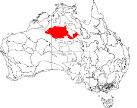 |
| Tanami Desert | TAN01 | 20,769,151 hectares (51,321,690 acres) | ||
| Wycliffe | TAN02 | 1,600,893 hectares (3,955,890 acres) | ||
| Sandover | TAN03 | 3,627,233 hectares (8,963,090 acres) | ||
| Tasmanian Central Highlands | TCH | 767,849 hectares (1,897,400 acres) | Tas |  |
| Central Highlands | TCH01 | |||
| Tasmanian Northern Midlands | TNM | 415,445 hectares (1,026,590 acres) | Tas |  |
| Northern Midlands | TNM01 | |||
| Tasmanian Northern Slopes | TNS | 623,103 hectares (1,539,720 acres) | Tas | 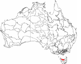 |
| Northern Slopes | TNS01 | |||
| Tasmanian South East | TSE | 1,131,822 hectares (2,796,790 acres) | Tas | 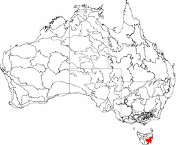 |
| South East | TSE01 | |||
| Tasmanian Southern Ranges | TSR | 757,228 hectares (1,871,150 acres) | Tas |  |
| Southern Ranges | TSR01 | |||
| Tasmanian West | TWE | 1,565,077 hectares (3,867,390 acres) | Tas |  |
| West | TWE01 | |||
| Tiwi Cobourg | TIW | 1,010,580 hectares (2,497,200 acres) | NT |  |
| Tiwi | TIW01 | 748,927 hectares (1,850,640 acres) | ||
| Coburg | TIW02 | 261,652 hectares (646,560 acres) | ||
V
| IBRA regions and subregions: IBRA7 | ||||
|---|---|---|---|---|
| IBRA region / subregion | IBRA code | Area | States | Location in Australia |
| Victoria Bonaparte | VIB | 7,301,242 hectares (18,041,760 acres) | NT / WA | 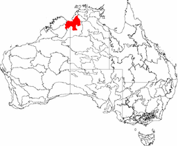 |
| Keep | VIB01 | 6,441,592 hectares (15,917,520 acres) | ||
| Hermit Creek | VIB02 | 170,646 hectares (421,680 acres) | ||
| Angalarri | VIB03 | 689,004 hectares (1,702,570 acres) | ||
| Victorian Midlands | VIM | 3,469,789 hectares (8,574,040 acres) | Vic |  |
| Goldfields | VIM01 | 1,326,133 hectares (3,276,950 acres) | ||
| Central Victorian Uplands | VIM02 | 1,217,922 hectares (3,009,550 acres) | ||
| Greater Grampians | VIM03 | 237,416 hectares (586,670 acres) | ||
| Dundas Tablelands | VIM04 | 688,318 hectares (1,700,870 acres) | ||
W
| IBRA regions and subregions: IBRA7 | ||||
|---|---|---|---|---|
| IBRA region / subregion | IBRA code | Area | States | Location in Australia |
| Warren | WAR | 844,771 hectares (2,087,470 acres) | WA | 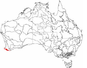 |
| Warren | WAR01 | |||
| Wet Tropics | WET | 1,989,107 hectares (4,915,190 acres) | Qld |  |
| Herbert | WET01 | 220,920 hectares (545,900 acres) | ||
| Tully | WET02 | 162,958 hectares (402,680 acres) | ||
| Innisfail | WET03 | 195,200 hectares (482,000 acres) | ||
| Atherton | WET04 | 177,037 hectares (437,470 acres) | ||
| Paluma-Seaview | WET05 | 233,751 hectares (577,610 acres) | ||
| Kirrama-Hinchinbrook | WET06 | 257,594 hectares (636,530 acres) | ||
| Bellenden Ker-Lamb | WET07 | 271,062 hectares (669,810 acres) | ||
| Macalister | WET08 | 112,652 hectares (278,370 acres) | ||
| Daintree-Bloomfield | WET09 | 357,932 hectares (884,470 acres) | ||

See also
- Ecoregions in Australia
- Integrated Marine and Coastal Regionalisation of Australia (IMCRA)
Further reading
- Haque, Md. Mohasinul; Nipperess, David A.; Gallagher, Rachael V.; Beaumont, Linda J. (2017). "How well documented is Australia's flora? Understanding spatial bias in vouchered plant specimens". Austral Ecology. 42 (6): 690–699. doi:10.1111/aec.12487. ISSN 1442-9985. (Discusses IBRA regions most likely to benefit from targeted floral sampling)
References
- "Australia's bioregions (IBRA)". Department of Sustainability, Environment, Water, Population and Communities. Commonwealth of Australia. 2012. Retrieved 13 January 2013.
- Interim Biogeographic Regionalisation for Australia (IBRA7) regions and codes.
- Interim Biogeographic Regionalisation for Australia (IBRA7) subregions and codes.