White Rock, New Mexico
White Rock is an unincorporated community and census-designated place (CDP) in Los Alamos County, New Mexico, United States. It is one of two major population centers in the county; the other is Los Alamos (the county seat). The population was 5,725 at the 2010 census.[1] It is largely a bedroom community for employees of Los Alamos National Laboratory and their families. Access to White Rock from the town of Los Alamos and other cities and towns in New Mexico is via New Mexico State Road 4, which forms the northwestern boundary of the community. Administratively, White Rock is a neighborhood of Los Alamos; locals refer to Los Alamos (meaning not White Rock) as "the Townsite," or "the Hill".
White Rock, New Mexico | |
|---|---|
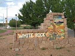 Sign at entrance to White Rock | |
 Location of White Rock, New Mexico | |
 White Rock, New Mexico Location in the United States | |
| Coordinates: 35°49′10″N 106°12′17″W | |
| Country | United States |
| State | New Mexico |
| County | Los Alamos |
| Area | |
| • Total | 7.11 sq mi (18.41 km2) |
| • Land | 7.07 sq mi (18.30 km2) |
| • Water | 0.04 sq mi (0.11 km2) |
| Elevation | 6,365 ft (1,940 m) |
| Population | |
| • Total | 5,725 |
| • Density | 810/sq mi (312.8/km2) |
| Time zone | UTC-7 (Mountain (MST)) |
| • Summer (DST) | UTC-6 (MDT) |
| ZIP code | 87547[2] |
| Area code(s) | 505 |
| FIPS code | 35-84740 |
| GNIS feature ID | 0912322 |
History
In 1947 the United States Atomic Energy Commission acquired land from the United States Forest Service to build a temporary community to house construction workers. That community was the first White Rock, which was abandoned by 1953. By 1958 all of the old White Rock buildings had been demolished or removed. The second and present White Rock was begun in 1962.
Geography
White Rock is located in southeastern Los Alamos County at 35°49′10″N 106°12′17″W (35.819439, -106.204779).[3] It is bordered to the north and east by Santa Fe; the eastern border follows the Rio Grande through White Rock Canyon. The elevation of the White Rock townsite is 6,365 feet (1,940 m), 900 feet (270 m) above the river elevation in the canyon. The CDP includes the neighborhood of Pajarito Acres, directly south of and at the same elevation as the White Rock townsite.
The center of the town of Los Alamos is 9 miles (14 km) northwest of White Rock, via New Mexico State Roads 4 and 502. A gated entrance to Los Alamos National Laboratory is on Pajarito Road, accessed directly from White Rock.
According to the United States Census Bureau, the White Rock CDP has a total area of 7.1 square miles (18.4 km2), of which 0.04 square miles (0.1 km2), or 0.59%, are water.[4]
White Rock Canyon
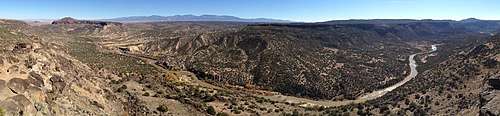
Largely undeveloped White Rock Canyon, on the eastern edge of the community, provides a wilderness recreation area heavily used by residents of White Rock and Santa Fe. The canyon was carved through basalt and tuff by the south-flowing Rio Grande. The canyon runs from the Otowi Suspension Bridge in the north and to Cochiti Dam in the south, with many smaller tributary canyons such Los Alamos, Mortandad, Water, Ancho, Frijoles, and Capulin Canyon. White Rock is situated on a portion of the west side of the canyon along with Bandelier National Monument, a section of Los Alamos National Laboratory, San Ildefonso Pueblo, Cochiti Pueblo, and Santa Fe National Forest. Across the river to the east rises the Caja del Rio.
For a few decades the Chili Line, a narrow gauge railroad, ran on the east bank of the river as far south as the mouth of Diablo Canyon; some day the Rio Grande Trail may occupy the abandoned right of way.
Averaging 1,000 feet (300 m) deep, the canyon provides spectacular vistas, rugged terrain and home to rare plant species as well as endangered animal species. Along the rim of the canyon are many basalt cliffs that are used by rock climbers.[5]
White Rock Canyon Rim Trail
- Distance: 2.8 miles (4.5 km) one way
- Elevation: 6,300 to 6,400 feet (2,000 m)
- Elevation Change: 100 feet (30 m)
- Fitness Level: Easy
- Seasons: All seasons
- Trail Surface: Rocks and packed dirt
- Hazards: Cliffs, rattlesnakes
Blue Dot Trail
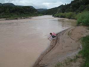
The trailhead begins about 100 yards southwest of the overlook viewing platform, and is accessible from a small parking lot at the end of the last side road branching east off Overlook Road. Partway to the river a meadow lies on top of a large Toreva block bench (a large piece of terrain which has moved downhill as a unit). At the midway point, the material underfoot changes from dark sharp basaltic rocks to light rounded granitic stones. The trail passes a large spring seeping from scree as the trail nears the Rio Grande. This water and water from the river are not safe to drink.
- Distance: 1.1-mile (1.8 km) one way
- Elevation: 5,450 to 6,250 feet (1,900 m)
- Elevation Change: 800 feet (240 m)
- Fitness Level: Strenuous, but short
- Seasons: All seasons, except after heavy snow
- Trail Surface: Rocky and steep trail
- Hazards: Cliffs, loose footing, swift river
Red Dot Trail
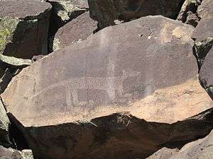
This trail, also known as Pajarito Springs Trail, is accessible from Piedra Loop in La Senda. Numerous petroglyphs appear along the way, unseen by many hikers concentrating on their footing on this very steep and challenging trail. The rock drawings are varied in style, from Kokopelli to abstract and geometric designs. The local Tewa may have imported some designs from Native Americans of the Great Plains. The Pajarito Springs are several in number and combine to form a small creek flowing into a pool via a small waterfall. The trail continues to the Rio Grande.
- Distance: 1.0-mile (1.6 km) one way
- Elevation: 5,500 to 6,300 feet (1,900 m)
- Elevation Change: 800 feet (240 m)
- Fitness Level: Strenuous, but short
- Seasons: All seasons, except after heavy snow
- Trail Surface: Very rocky trail
- Hazards: Cliffs, loose footing, swift river
River Trail
- Distance: 3.2 miles (5.1 km) one way
- Elevation: 5,400 to 5,500 feet (1,700 m)
- Elevation Change: 100 feet (30 m)
- Fitness Level: Easy
- Skill Level: Sections of the trail require route-finding ability
- Seasons: All seasons, except after heavy snow
- Trail Surface: Sand, river cobbles and rocks
- Hazards: Swift river
Demographics
As of the census[6] of 2000, there were 6,045 people, 2,226 households, and 1,860 families residing in the CDP. The population density was 841.9 people per square mile (325.1/km²). There were 2,282 housing units at an average density of 317.8 per square mile (122.7/km²). The racial makeup of the CDP was 92.75% White, 0.25% African American, 0.53% Native American, 2.68% Asian, 0.02% Pacific Islander, 1.87% from other races, and 1.90% from two or more races. Hispanic or Latino of any race were 10.59% of the population.
There were 2,226 households out of which 38.0% had children under the age of 18 living with them, 78.2% were married couples living together, 3.2% had a female householder with no husband present, and 16.4% were non-families. 13.8% of all households were made up of individuals and 4.9% had someone living alone who was 65 years of age or older. The average household size was 2.71 and the average family size was 2.99.
In the CDP, the population was spread out with 27.6% under the age of 18, 3.3% from 18 to 24, 24.1% from 25 to 44, 34.2% from 45 to 64, and 10.8% who were 65 years of age or older. The median age was 42 years. For every 100 females, there were 101.4 males. For every 100 females age 18 and over, there were 99.2 males.
The median income for a household in the CDP was $92,813, and the median income for a family was $96,716. Males had a median income of $77,216 versus $44,145 for females. The per capita income for the CDP was $36,288. About 1.1% of families and 1.3% of the population were below the poverty line, including 0.4% of those under age 18 and 3.0% of those age 65 or over.
White Rock Master Plan
The commercial center of White Rock has been in decline since approximately 1990, due in part to loss of retail revenues to the Internet and to "big box" stores in nearby communities. Los Alamos County recently began a major effort to revitalize the White Rock commercial center by improving infrastructure and seeking to attract new businesses. Part of the motivation for this effort is the transfer to Los Alamos County of Department of Energy lands just north of State Road 4. The revitalization effort has emphasized community input and is presently being driven by the White Rock Master Plan Implementation Committee, with the support of the County Council.[7]
Community Parks and Tot Lots
Overlook Park
- playground
- 1 youth baseball field (non-lighted)
- 2 youth baseball fields (lighted)
- 5 softball fields (non-lighted)
- 1 softball field (lighted)
- 4 soccer fields (non-lighted)
- 3 independent picnic areas
- 1 dog park
- 1 rc car track
- 1 area viewing platform (the overlook)
Piñon Park
- playground
- 2 full basketball courts
- 3 tennis courts
- 1 skateboard park
- Disk Golf Course
Rover Park
- playground
- 1 full basketball court
- 2 tennis courts
- 1 soccer field (non-lighted)
Jeffrey Tot Lot
- playground
Mountain Meadows Tot Lot
- playground
Schools
- Piñon Elementary School
- Chamisa Elementary School
References
- "Total Population: 2010 Census DEC Summary File 1 (P1), White Rock CDP, New Mexico". data.census.gov. U.S. Census Bureau. Retrieved May 18, 2020.
- "Zipdatamaps". Retrieved 2016-07-29.
- "US Gazetteer files: 2010, 2000, and 1990". United States Census Bureau. 2011-02-12. Retrieved 2011-04-23.
- "U.S. Gazetteer Files: 2019: Places: New Mexico". U.S. Census Bureau Geography Division. Retrieved May 18, 2020.
- "White Rock Climbing Areas". Los Alamos Mountaineers. Retrieved 2011-07-07.
- "U.S. Census website". United States Census Bureau. Retrieved 2008-01-31.
- "White Rock Master Plan". Los Alamos County. Retrieved 2009-11-10.
Hoard, Dorothy (1981). Los Alamos Outdoors. Los Alamos, New Mexico: The Los Alamos Historical Society. ISBN 0-941232-03-4.
External links
| Wikimedia Commons has media related to White Rock, New Mexico. |
- Los Alamos County
- White Rock Master Plan
- White Rock Realtime Weather
- LANL TA-54 weather tower adjacent to intersection of Grand Canyon and State Road 4
- Rock Climbing Routes in White Rock Canyon
Municipalities and communities of Los Alamos County, New Mexico, United States | ||
|---|---|---|
| CDPs |  Map of New Mexico highlighting Los Alamos County | |