List of peninsulas
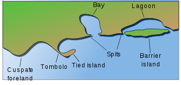
A peninsula (Latin: paeninsula from paene "almost" and insula "island") is a piece of land that is bordered by water on three sides but connected to mainland.[1][2][3][4] The surrounding water is usually understood to be continuous, though not necessarily named as such. A peninsula can also be a headland, cape, island promontory, bill, point, or spit.[5] A point is generally considered a tapering piece of land projecting into a body of water that is less prominent than a cape.[6] In English, the plural of peninsula is peninsulas or, less commonly, peninsulae. A river which courses through a very tight meander is also sometimes said to form a "peninsula" within the (almost closed) loop of water.
_250m.jpg)
Presented below is a list of peninsulas.
Africa
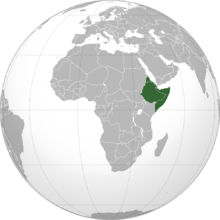
Somali peninsula
The Horn of Africa is a peninsula in Northeast Africa that juts into the Guardafui Channel, and is the easternmost projection of the African continent. It denotes the region containing the countries of Somalia, Eritrea, Djibouti and Ethiopia.
- Buri Peninsula, Eritrea
- Ras Hafun, Somalia
- Ras Kasar, Eritrea
- Ras Siyyan, Djibouti
North Africa
- Cabo Blanco, Mauritania/Morocco
- Cap Bon, Tunisia
- Cap Zebib, Tunisia
- Ceuta, Spain
- Río de Oro Peninsula, Western Sahara
- Ponta de São Lourenço, Madeira Islands (Portuguese Territory)
- Ras Banas, Egypt
- Sinai Peninsula, Egypt
- Ras ben Sakka, Tunisia
Other
- Bakassi, Cameroon but disputed with Nigeria
- Cap-Vert, Senegal
- Turner's Peninsula, Sierra Leone
- Cape Peninsula, South Africa
- Le Morne Brabant, Mauritius
Antarctica
- Antarctic Peninsula
- Edward VII Peninsula
- Fletcher Peninsula
- Fowler Peninsula
- Martin Peninsula
Asia
China
- Liaodong Peninsula
- Shandong Peninsula
- Leizhou Peninsula
- Shanghai Peninsula
Hong Kong
Macau
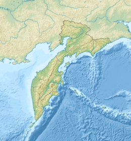
Russia
Taiwan
Turkey
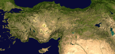
- Anatolian Peninsula
- Armutlu Peninsula
- Biga Peninsula
- Datça Peninsula
- Dilek Peninsula
- Karaburun Peninsula
- Kapıdağ Peninsula
- Kocaeli Peninsula
- Sinop Peninsula
- Teke Peninsula
Indian subcontinent and South Asia

The Indian subcontinent is a peninsula, the only land feature in the world widely recognized as a subcontinent in the English language.
- Colaba peninsula, Mumbai
- Deccan peninsula
- Worli peninsula, Mumbai
- Kathiawar Peninsula, Gujarat
- Gwadar peninsula, Pakistan
- Manhoro, Karachi, Sindh, Pakistan
- Jaffna Peninsula, Northern Sri Lanka
- Kanyakumari peninsula, Tamil Nadu
Japan
Kyūshū
- Nishi-sonogi-hanto
- Kunisaki-hanto
- Satsuma-hanto
- Ōsumi-hanto
Hokkaido
Kazakhstan
Korea
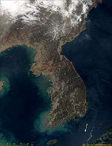
The whole land mass encompassing North and South Korea is a peninsula, surrounded by the Sea of Japan (East Sea) on the east, the East China Sea to the south, and the Yellow Sea to the west, with the Korea Strait connecting the first two bodies of water.
Persian Gulf
- Arabian Peninsula; Saudi Arabia, Iraq, Kuwait, Bahrain, Qatar, Jordan, United Arab Emirates, Yemen, Oman
- Qatar
- Al-Faw Peninsula, Iraq
- Musandam Peninsula; Oman, United Arab Emirates
Indochina
Indonesia
- Blambangan Peninsula, Java,
- Semenanjung Minahassa, Sulawesi
- East Peninsula, Sulawesi
- South-east Peninsula, Sulawesi
- South Peninsula, Sulawesi
Malaysia
- Malay Peninsula
- Northwestern Peninsula, Kudat
- Pitas Peninsula, Pitas
- Semporna Peninsula, Semporna and Tawau
- Sandakan Peninsula, Sandakan
Philippines
- Bataan Peninsula, Luzon
- Bicol Peninsula, Luzon
- Caramoan Peninsula, Bicol
- Bondoc Peninsula, Luzon
- Cavite City, Luzon
- San Ildefonso Peninsula, Luzon
- Zamboanga Peninsula, Mindanao
- Tinaca Point, Davao del Sur
- Pujada Peninsula, Mindanao
- Northwest Panay Peninsula, Visayas
Singapore
Vietnam
- Cà Mau Peninsula, Cà Mau Province
- Hòn Gốm Peninsula, Da Lat City
- Sơn Trà Peninsula, Da Nang
- Ngũ Xã Peninsula, Hanoi
- Bình Quới Peninsula, Ho Chi Minh City
- Cam Ranh Peninsula, Khánh Hòa Province
- Đầm Môn Peninsula
- Trà Cổ Peninsula, Quảng Ninh Province
- Phương Mai Peninsula, Qui Nhơn
Europe
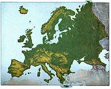
Europe is sometimes considered to be a large peninsula extending off Eurasia.[7] As such, it is one of the largest peninsulas in the world and the only one to have the status as a full continent, largely as a matter of convention rather than science. It is composed of many smaller peninsulas, the four main and largest component peninsulas being the Scandinavian, Iberian, Balkan and Italian peninsulas.
Balkan Peninsula
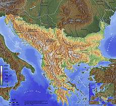
The Balkans is a peninsula including Albania, Bosnia and Herzegovina, Bulgaria, Croatia, Greece, Kosovo, North Macedonia, Montenegro, Romania, Serbia, Slovenia and the European part of Turkey.
- Chalkidiki, Greece
- Kassandra, Greece
- Mani Peninsula, Greece
- Mount Athos, Greece
- Peloponnese, Greece (now an island because of the Corinth Canal)
- Sithonia, Greece
- Pilio, Greece
- Istria, Croatia
- Piran Peninsula, Slovenia
- Pelješac, Croatia
- Prevlaka, Croatia
- Split, Croatia
- Zadar, Croatia
- Karaburun Peninsula, Albania
- Luštica, Montenegro
- Gallipoli, Turkey
France
- Brittany
- Cap Corse, Corsica
- Cotentin Peninsula, Normandy
- Crozon, Finistère
- Landes du Médoc, Aquitaine
Iberian Peninsula
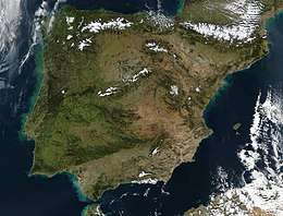
Encompassing continental Spain and Portugal, Andorra, British overseas territory of Gibraltar and a small amount of southern France.
- Lisbon Peninsula, Portugal
- Setúbal Peninsula, Portugal
- Peniche, Portugal
- Cabo Espichel, Portugal
- Cabo Carvoeiro, Portugal
- Cabo de São Vicente, Portugal
- Tróia Peninsula, Portugal
- Gibraltar
- Cádiz, Andalusia, Spain
- A Coruña, Galicia, Spain
- O Morrazo, Pontevedra, Galicia, Spain
- Macizo de Anaga, Tenerife, Canary Islands, Spain
- Jandía, Fuerteventura, Canary Islands, Spain
- La Isleta, Spain
Ireland
Italy
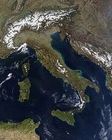
- Italian Peninsula
- Calabria
- Promontorio del Gargano
- Salento
- Sorrentine Peninsula
- Promontorio di Orbetello
Malta
Russia
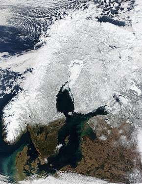
Scandinavia
Scandinavia is a region in Northern Europe, with strong historical, cultural, and linguistic ties. The term Scandinavia in local usage covers the three kingdoms of Denmark, located on the Jutland Peninsula, and Norway and Sweden, located the on the Scandinavian Peninsula.[8] In English usage, Scandinavia also sometimes refers to the Scandinavian Peninsula, or to the broader region including Finland and Iceland, which is always known locally as the Nordic countries.[9][10]
The Scandinavian Peninsula, along with the islands, encompasses present-day Sweden, Norway, and the northwestern area of Finland.
Fennoscandia or the Fennoscandian Peninsula is the geographical peninsula comprising the Scandinavian Peninsula, Finland, Karelia, and the Kola Peninsula (Russia).
Norway
- Bergen Peninsula
- Bygdøy
- Brøggerhalvøya, Norway
- Fornebulandet
- Fosen
- Hamarøyhalvøya
- Hurumlandet
- Lista
- Lyngenhalvøya
- Nordkinn Peninsula
- Nesodden
- Ofothalvøya
- Porsangerhalvøya
- Snarøya, Norway
- Stad
- Stavanger Peninsula
- Sværholt Peninsula
- Varangerhalvøya
Sweden
Denmark
- Djursland
- Grenen
- Helgenæs
- Hindsholm
- Horne Land
- Hornsherred
- Jutland Peninsula (now an island, since the Kiel Canal was made)
- Kegnæs
- Mols
- Odsherred
- Salling
- Stevns Peninsula
- Sundeved
Estonia
Turkey
- Gallipoli Peninsula
- Thracian Peninsula
Ukraine
- Crimean peninsula, occupied by Russia
- Chonhar Peninsula
- Kinburn peninsula
- Rybalskyi Peninsula
United Kingdom
England
- South West Peninsula (western part of the West Country comprising the counties of Cornwall, Devon, Somerset, and Dorset)
- Dengie peninsula, Essex
- The centre of the city of Durham, County Durham
- The Fylde, Lancashire
- Brixham Peninsula, South Devon
- Hoo, Kent
- Roseland, Mid Cornwall
- Bere Peninsula, Devon
- Isle of Dogs, London
- Cartmel Peninsula, Cumbria
- Furness Peninsula, Cumbria
- Greenwich Peninsula, London
- Gosport, Hampshire
- Isle of Thanet, Kent
- The Lizard, Cornwall
- Dawlish Warren National Nature Reserve, South Devon
- Manhood Peninsula, West Sussex
- Morte Point, North Devon
- Penwith, Cornwall
- Isle of Purbeck, Dorset
- Isle of Portland, Dorset
- Rotherhithe, London
- Spurn, East Riding of Yorkshire
- Shotley Peninsula, Suffolk
- Tendring, Essex
- Wirral, Cheshire/Merseyside
Scotland
- Ardnamurchan, Lochaber
- Black Isle, Ross and Cromarty
- Cowal, Argyll and Bute
- Doonie Point, Aberdeenshire
- Dunnet Head, Caithness
- Faraid Head, Sutherland
- Fife
- Kintyre, Argyll and Bute
- Knoydart, Lochaber
- The Machars, Dumfries and Galloway
- Morvern, Lochaber
- Northmavine, Shetland
- Rhins of Galloway, Dumfries and Galloway
- Rosneath peninsula, Argyll and Bute (formerly Dunbartonshire)
- Strathy Point, Sutherland
- Point of Hellia, Orkney
- Point or the Eye peninsula, Western Isles
Wales
- Creuddyn Peninsula just out of the North Wales coast
- Gower Peninsula, Swansea
- Llŷn Peninsula
- Marloes Peninsula, Pembrokeshire
- South Pembrokeshire Peninsula
- St Davids Head, Pembrokeshire
Northern Ireland
- Ards Peninsula, County Down
- Island Magee
- Lecale peninsula
- Ramore Head, Portrush
- Oxford Island
Other peninsulas in Europe
- Absheron peninsula, Azerbaijan
- Akranes, Iceland
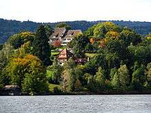
- Au peninsula, Au, Zurich, Switzerland
- Butjadingen, Germany
- Curonian Spit, Lithuania (shared with Russia)
- Fischland-Darß-Zingst, Germany
- Hel Peninsula, Poland
- Heracles Peninsula, disputed between Ukraine and Russia
- Kerch Peninsula, disputed between Ukraine and Russia
- Karpass Peninsula, Cyprus
- North Holland, the Netherlands
- Nesebar Peninsula, Bulgaria
- Sozopol Peninsula, Bulgaria
- Tihany, Hungary
- Walcheren, the Netherlands
- Zuid-Beveland, the Netherlands
North America
Belize
- Placencia Peninsula, Belize
Canada
- Dunlas Peninsula, Melville Island, Northwest Territories/Nunavut
- Labrador Peninsula, encompassing all of Labrador and most of Quebec
- Natkusiak Peninsula, Victoria Island, Northwest Territories/Nunavut
- Storkerson Peninsula, Victoria Island, Northwest Territories/Nunavut
- Wollaston Peninsula, Victoria Island, Northwest Territories/Nunavut
British Columbia
- Burrard Peninsula
- Saanich Peninsula, Vancouver Island
- Sunshine Coast Peninsula, Sea-to-Sky Corridor
- Tsawwassen Peninsula, which extends beyond the Canada/United States border, creating the pene-exclave of Point Roberts, Washington
Northwest Territories
- Diamond Jennes Peninsula, Victoria Island
- Douglas Peninsula
- Leith Peninsula (in Great Bear Lake)
- Parry Peninsula
- Pethel Peninsula
- Prince Albert Peninsula, Victoria Island
- Sahoyúé-§ehdacho
Nova Scotia
- Aspotogan Peninsula
- Chebucto Peninsula
- Nova Scotia peninsula
- Pubnico Peninsula
Baffin Island
- Barrow Peninsula
- Becher Peninsula
- Beekman Peninsula
- Bell Peninsula
- Blunt Peninsula
- Borden Peninsula
- Brodeur Peninsula
- Cumberland Peninsula
- Foxe Peninsula
- Hall Peninsula
- Henry Kater Peninsula
- Meta Incognita Peninsula
- Siorarsuk Peninsula
- Steensby Peninsula
Ontario
- Cynthia Peninsula (in Lake Temagami)
- Joan Peninsula (in Lake Temagami)
- McLean Peninsula (in Lake Temagami)
- North Peninsula (in Lake Nipigon)
- Ontario Peninsula
- Bruce Peninsula, extending into Lake Huron
- Long Point (in Lake Erie)
- Niagara Peninsula
- Point Pelee (in Lake Erie)
- Prince Edward Peninsula (in Lake Ontario)
- Sibley Peninsula (in Lake Superior)
Caribbean
- Peninsula de Samaná, Dominican Republic
- Barrio Obrero, Puerto Rico
- Zapata Peninsula, Cuba
- Guanahacabibes Peninsula, Cuba
- Hicacos Peninsula, Cuba
- Vigie Peninsula, St Lucia
Costa Rica
- Nicoya Peninsula, Costa Rica
- Osa Peninsula, Costa Rica
Greenland
- Alfred Wegeners Halvo
- Hayes Halvo
- Ingnerit
- Nuussuaq Peninsula
- Sigguup Nunaa (Svartenhuk Halvø)
Mexico
- Baja California Peninsula, Mexico, containing the states of Baja California and Baja California Sur
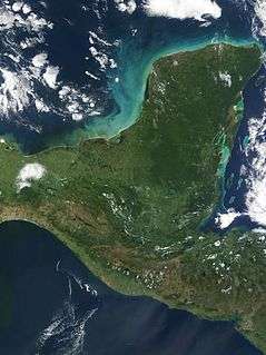
- Yucatán Peninsula, partly separating the Gulf of Mexico from the Caribbean
Panama
- Península de Azuero, Panama
United States
Alaska
- Alaska Peninsula
- Cleveland Peninsula
- Kenai Peninsula
- Seward Peninsula
- Lisburne Peninsula
California
- Balboa Peninsula – in Newport Beach, Orange County.
- Monterey Peninsula – between Monterey Bay, the Salinas Valley, and the Santa Lucia Range in Monterey County.
- Palos Verdes Peninsula – along the Pacific between Santa Monica Bay and San Pedro Bay, in the South Bay Region of Los Angeles County.
- Point Loma Peninsula – between San Diego Bay and the Pacific Ocean in San Diego.
- San Francisco Peninsula – between the central−south San Francisco Bay and the Pacific in the San Francisco Bay Area. The Santa Cruz Mountains are a 'spine' along the middle & lower sections.
- Samoa Peninsula – the northern landform between Humboldt Bay and the Pacific
- Tiburon Peninsula – between Richardson Bay and San Pablo Bay in east Marin County of the northern San Francisco Bay Area.
Florida
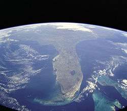
Florida is a well-known example of a large peninsula, with its land area divided between the larger Florida peninsula and the smaller Florida panhandle on the north and west. It has several smaller peninsulas within it:
- The St. Johns River creates a large peninsula over 75 miles in length that stretches from eastern Jacksonville down to the border of Flagler and Volusia counties, where the river emanates from Lake George.
- Fairpoint Peninsula
- Pinellas peninsula, including St. Petersburg and Clearwater
- Much of Tampa lies on a peninsula called Interbay Peninsula jutting out into Tampa Bay
- Cape Sable
Maryland
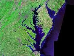
- Maryland shares the Delmarva Peninsula east of Chesapeake Bay with Delaware and Virginia.
- St. Mary's Peninsula is defined by the Patuxent River, the Potomac River, and Chesapeake Bay.
- Calvert Peninsula lies between Chesapeake Bay and the Patuxent River.
- Numerous smaller tidal tributaries form smaller peninsulas on both the Eastern and Western shores of Chesapeake Bay. Named examples include the Broadneck Peninsula in Anne Arundel County and the Elk Neck Peninsula in Cecil County.
Massachusetts

- Cape Cod, Massachusetts, a cape that can be viewed as a peninsula
- Nahant, a town in Essex County, is on a small peninsula.
- Nantasket Peninsula, Hull
- Shawmut Peninsula, Boston
Michigan
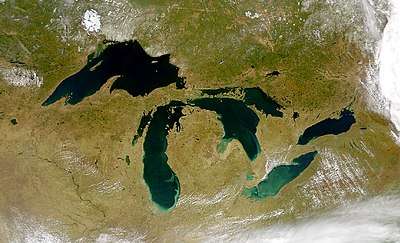
Michigan – the only bi-peninsular state – is very distinguishable for its mitten-shaped Lower Peninsula of Michigan which includes:
- Leelanau Peninsula
- Lost Peninsula
- Old Mission Peninsula
- Pointe Mouillee
- Presque Isle Peninsula
- Tawas Point
- The Thumb
- Waugoshance Point
- Woodtick Peninsula
The rifle-shaped Upper Peninsula of Michigan contains:
- Abbaye Peninsula
- Garden Peninsula
- Keweenaw Peninsula
- Rabbit's Back
- Stonington Peninsula
New Jersey
- Barnegat Peninsula
- Cape May Peninsula
- Sandy Hook
- New Barbadoes Neck lies between the Hackensack River and Passaic River
- Caven Point in Jersey City is a part of Liberty State Park and Port Liberte.
- Bergen Point and Constable Hook are two peninsulas in Bayonne, which itself lies on peninsula surrounded by Upper New York Bay, Newark Bay, and the Kill van Kull, formerly known as Bergen Neck
- Droyer's Point and Kearny Point mark the mouth of the Hackensack River
- MOTBY and Port Jersey are man-made peninsulas extending in Upper New York Bay
New York
- The Bronx, New York, and Yonkers, New York
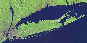
- Long Island was once a peninsula connected to North America during the great Ice Ages, and includes two large peninsulas at its east end: the South Fork and the North Fork.
- Cumberland Head
- Coney Island was an island until it was expanded through land reclamation into the Coney Island Creek, thus becoming a peninsula.
- Rockaway Peninsula in southeastern Queens
- Irondequoit, NY (geographical headland)
Utah
- Antelope Island, Utah, becomes a peninsula when waters are low, on the south shore of the Great Salt Lake
- Promontory Peninsula, on the north eastern shore of the Great Salt Lake
- Stansbury Peninsula becomes an island when waters are high, on the south shore of the Great Salt Lake
Vermont
Virginia
- Middle Peninsula, on the western shore of the Chesapeake Bay
- Northern Neck, on the western shore of the Chesapeake Bay
- Virginia Peninsula, on the western shore of the Chesapeake Bay
Washington
- Key Peninsula in Puget Sound
- Kitsap Peninsula in Puget Sound
- Long Beach Peninsula
- Olympic Peninsula
- Magnolia, Seattle
- Tsawwassen Peninsula, which extends beyond the Canada/United States border, creating the pene-exclave of Point Roberts, Washington
Other states
- Delmarva Peninsula, encompassing parts of Maryland and Virginia, and most of Delaware
- Bark Point, Wisconsin in Lake Superior
- Bayfield Peninsula, Wisconsin in Lake Superior
- Chequamegon Point, Wisconsin in Lake Superior
- Door Peninsula, Wisconsin, in Lake Michigan
- Jones Island, Milwaukee, Wisconsin in Lake Michigan
- Land Between the Lakes, Tennessee and Kentucky (the largest inland peninsula in the United States)
- Little Tail Point, Wisconsin in Green Bay (Lake Michigan)
- Marshall's Point, Wisconsin on North Bay in Lake Michigan
- Mawikwe Point, Wisconsin on Mawikwe Bay in Lake Superior
- Mokapu, Hawaii
- Presque Isle, Erie, Pennsylvania
- Port Bolivar, Texas
- Roman Point on Siskiwit Bay, Wisconsin, in Lake Superior
- Toft Point between Bailey's Harbor, Wisconsin and Moonlight Bay, Wisconsin in Lake Michigan
- Encinal Peninsula, Flour Bluff, Corpus Christi, Texas
- Kentucky Bend, Kentucky
South America
- Araya Peninsula, Venezuela
- Paraguana, Venezuela
- Paria Peninsula, Venezuela
- Guajira Peninsula, Venezuela/Colombia
- Illescas Peninsula, Peru
- Paracas Peninsula, Peru
- Verde Peninsula, Argentina
- Valdes Peninsula, Argentina
- Punta del Este, Uruguay
- Taitao Peninsula, Chile
- Brunswick Peninsula, Chile
- Itapagipe Peninsula, Brazil
- Cabo de São Tomé, Brazil
Oceania
Australia
- Beecroft Peninsula, New South Wales
- Bellarine Peninsula, Victoria
- Cape York Peninsula, Queensland
- Cobourg Peninsula, Northern Territory
- Kurnell Peninsula, New South Wales
- Dampier Peninsula, Western Australia
- Dudley Peninsula, South Australia
- Eyre Peninsula, South Australia
- Fleurieu Peninsula, South Australia
- Freycinet Peninsula, Tasmania
- Inskip Peninsula, Queensland
- Jervis Bay, Australian Capital Territory
- Mornington Peninsula, Victoria
- Redcliffe, Queensland
- Sir Richard Peninsula, South Australia
- Stockton, New South Wales
- Tasman Peninsula, Tasmania
- Wilsons Promontory, Victoria
- Woy Woy, New South Wales
- Yorke Peninsula, South Australia
- Younghusband Peninsula, South Australia
Papua New Guinea
New Zealand
- In the North Island
- In the South Island
- Banks Peninsula
- Bluff Peninsula
- Brunner Peninsula, Saint Arnaud
- Cape Campbell
- Cape Foulwind
- D'Urville-Peninsula, D'Urville Island
- Farewell Spit
- Kaikoura Peninsula
- McBrides Peninsula, Lake Monowai
- Otago Peninsula
- Tautuku Peninsula
- The Peninsula and Roys Peninsula, Lake Wanaka
- Tiwai Point
References
- Word Histories and Mysteries: From Abracadabra to Zeus. Houghton Mifflin Harcourt. 2004. p. 216. ISBN 978-0547350271. OCLC 55746553.
- "pen·in·su·la". American Heritage Dictionary of the English Language. Houghton Mifflin Harcourt. 2016. Retrieved 1 May 2016.
- "Definition of peninsula". Cambridge Dictionaries Online. Cambridge University Press. Retrieved 1 May 2016.
- A PENINSULA IS A PENGUIN OCEAN "Definition of peninsula" Check
|url=value (help). Merriam-Webster Dictionary. Merriam-Webster. Retrieved 1 May 2016. - "List of peninsulas". Encyclopædia Britannica, Inc. 2016. Retrieved 1 May 2016.
- http://travelingluck.com/Africa/Sierra%20Leone/Northern/_2409328_Fourah+Point.html#local_map
- National Geographic, ed. (1996). "Peninsula". Retrieved 18 January 2015.
- John Harrison, Michael Hoyler, Megaregions: Globalization's New Urban Form? (p. 152), Edward Elgar Publishing, 2015
- "Definition of Scandinavia in English". Oxford Dictionaries. Retrieved 23 December 2016.
A large peninsula in north-western Europe, occupied by Norway and Sweden … A cultural region consisting of the countries of Norway, Sweden, and Denmark and sometimes also of Iceland, Finland, and the Faroe Islands
- "Facts about the Nordic region". Nordic Council of Ministers & Nordic Council. 1 October 2007. Archived from the original on 8 February 2018. Retrieved 25 March 2014.
Denmark, Finland, Iceland, Norway, Sweden and the Faroe Islands, Greenland and Åland work together in the official Nordic co-operation.
External links