Continental shelf
A continental shelf is a portion of a continent that is submerged under an area of relatively shallow water known as a shelf sea. Much of these shelves has been exposed during glacial periods and interglacial periods. The shelf surrounding an island is known as an insular shelf.
| Marine habitats |
|---|
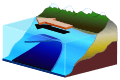
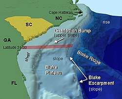 Anatomy of a continental shelf of the south eastern coast of the United States |
The continental margin, between the continental shelf and the abyssal plain, comprises a steep continental slope, surrounded by the flatter continental rise, in which sediment from the continent above cascades down the slope and accumulates as a pile of sediment at the base of the slope. Extending as far as 500 km (310 mi) from the slope, it consists of thick sediments deposited by turbidity currents from the shelf and slope.[1] The continental rise's gradient is intermediate between the gradients of the slope and the shelf.
Under the United Nations Convention on the Law of the Sea, the name continental shelf was given a legal definition as the stretch of the seabed adjacent to the shores of a particular country to which it belongs.
Geographical distribution
The width of the continental shelf varies considerably – it is not uncommon for an area to have virtually no shelf at all, particularly where the forward edge of an advancing oceanic plate dives beneath continental crust in an offshore subduction zone such as off the coast of Chile or the west coast of Sumatra. The largest shelf – the Siberian Shelf in the Arctic Ocean – stretches to 1,500 kilometers (930 mi) in width. The South China Sea lies over another extensive area of continental shelf, the Sunda Shelf, which joins Borneo, Sumatra, and Java to the Asian mainland. Other familiar bodies of water that overlie continental shelves are the North Sea and the Persian Gulf. The average width of continental shelves is about 80 km (50 mi). The depth of the shelf also varies, but is generally limited to water shallower than 100 m (330 ft).[2] The slope of the shelf is usually quite low, on the order of 0.5°; vertical relief is also minimal, at less than 20 m (66 ft).[3]
Though the continental shelf is treated as a physiographic province of the ocean, it is not part of the deep ocean basin proper, but the flooded margins of the continent.[4] Passive continental margins such as most of the Atlantic coasts have wide and shallow shelves, made of thick sedimentary wedges derived from long erosion of a neighboring continent. Active continental margins have narrow, relatively steep shelves, due to frequent earthquakes that move sediment to the deep sea.[5]
| Ocean | Active Margin Mean (km) | Active Margin Maximum (km) | Passive Margin Mean (km) | Passive Margin Maximum (km) | Total Margin Mean (km) | Total Margin Maximum (km) |
|---|---|---|---|---|---|---|
| Arctic Ocean | 0 | 0 | 104.1 ± 1.7 | 389 | 104.1 ± 1.7 | 389 |
| Indian Ocean | 19 ± 0.61 | 175 | 47.6 ± 0.8 | 238 | 37 ± 0.58 | 238 |
| Mediterranean and Black Seas | 11 ± 0.29 | 79 | 38.7 ± 1.5 | 166 | 17 ± 0.44 | 166 |
| North Atlantic Ocean | 28 ± 1.08 | 259 | 115.7 ± 1.6 | 434 | 85 ± 1.14 | 434 |
| North Pacific Ocean | 39 ± 0.71 | 412 | 34.9 ± 1.2 | 114 | 39 ± 0.68 | 412 |
| South Atlantic Ocean | 24 ± 2.6 | 55 | 123.0 ± 2.5 | 453 | 104 ± 2.4 | 453 |
| South Pacific Ocean | 214 ± 2.86 | 357 | 96.1 ± 2.0 | 778 | 110 ± 1.92 | 778 |
| All Oceans | 31 ± 0.4 | 412 | 88.2 ± 0.7 | 778 | 57 ± 0.41 | 778 |
Topography

The shelf usually ends at a point of increasing slope[7] (called the shelf break). The sea floor below the break is the continental slope. Below the slope is the continental rise, which finally merges into the deep ocean floor, the abyssal plain. The continental shelf and the slope are part of the continental margin.
The shelf area is commonly subdivided into the inner continental shelf, mid continental shelf, and outer continental shelf, each with their specific geomorphology and marine biology.
The character of the shelf changes dramatically at the shelf break, where the continental slope begins. With a few exceptions, the shelf break is located at a remarkably uniform depth of roughly 140 m (460 ft); this is likely a hallmark of past ice ages, when sea level was lower than it is now.[8]
The continental slope is much steeper than the shelf; the average angle is 3°, but it can be as low as 1° or as high as 10°.[9] The slope is often cut with submarine canyons. The physical mechanisms involved in forming these canyons were not well understood until the 1960s.[10]
Sediments
The continental shelves are covered by terrigenous sediments; that is, those derived from erosion of the continents. However, little of the sediment is from current rivers; some 60–70% of the sediment on the world's shelves is relict sediment, deposited during the last ice age, when sea level was 100–120 m lower than it is now.[11]
Sediments usually become increasingly fine with distance from the coast; sand is limited to shallow, wave-agitated waters, while silt and clays are deposited in quieter, deep water far offshore.[12] These accumulate 15–40 cm every millennium, much faster than deep-sea pelagic sediments.[13]
Shelf seas
Shelf seas refer to the ocean waters on the continental shelf. Their motion is controlled by the combined influences of the tides, wind-forcing and brackish water formed from river inflows (Regions of Freshwater Influence). These regions can often be biologically highly productive due to mixing caused by the shallower waters and the enhanced current speeds. Despite covering only about 8% of the Earth's ocean surface area,[14] shelf seas support 15-20% of global primary productivity.[15]
While the North Sea is one of the better studied shelf seas,[16] it is not necessarily representative of all shelf seas as there is a wide variety of behaviours to be found. Indian Ocean shelf seas are dominated by major river systems including the Ganges and Indus rivers.[17] The shelf seas around New Zealand are complicated because the submerged continent of Zealandia creates wide plateaus.[18] Shelf seas around Antarctica and the shores of the Arctic Ocean are influenced by sea ice production and polynya.[19]
There is evidence that changing wind, rainfall, and regional ocean currents in a warming ocean, is having an effect on some shelf seas.[20] Improved data collection via Integrated Ocean Observing Systems in shelf sea regions is making identification of these changes possible.[21]
Biota
Continental shelves teem with life because of the sunlight available in shallow waters, in contrast to the biotic desert of the oceans' abyssal plain. The pelagic (water column) environment of the continental shelf constitutes the neritic zone, and the benthic (sea floor) province of the shelf is the sublittoral zone.[22] The shelves makes up less than ten percent of the ocean, and a rough estimate suggest that only about 30% of the continental shelf sea floor receives enough sunlight to allow benthic photosynthesis.[23]
Though the shelves are usually fertile, if anoxic conditions prevail during sedimentation, the deposits may over geologic time become sources for fossil fuels.
Economic significance
The relatively accessible continental shelf is the best understood part of the ocean floor. Most commercial exploitation from the sea, such as metallic-ore, non-metallic ore, and hydrocarbon extraction, takes place on the continental shelf.[24]
Sovereign rights over their continental shelves up to a depth of 100 m (330 ft) or to a distance where the depth of waters admitted of resource exploitation were claimed by the marine nations that signed the Convention on the Continental Shelf drawn up by the UN's International Law Commission in 1958. This was partly superseded by the 1982 United Nations Convention on the Law of the Sea.[25] which created the 200 nautical miles (370 km; 230 mi) exclusive economic zone, plus continental shelf rights for states with physical continental shelves that extend beyond that distance.
The legal definition of a continental shelf differs significantly from the geological definition. UNCLOS states that the shelf extends to the limit of the continental margin, but no less than 200 nmi (370 km; 230 mi) and no more than 350 nmi (650 km; 400 mi) from the baseline. Thus inhabited volcanic islands such as the Canaries, which have no actual continental shelf, nonetheless have a legal continental shelf, whereas uninhabitable islands have no shelf.
See also
- Baseline
- Continental Island
- Continental shelf pump
- Continental shelf of Russia
- Exclusive economic zone
- International waters
- Land bridge
- Outer Continental Shelf
- Region of Freshwater Influence
- Territorial waters
- Passive margin
Notes
- Pinet 39, Gross 45.
- Pinet, 37.
- Pinet 36–37.
- Pinet 35–36.
- Pinet 90–93
- Harris PT, Macmillan-Lawler M, Rupp J, Baker EK. 2014. Geomorphology of the oceans. Marine Geology. 352:4–24.
- "shelf break – geology". Encyclopædia Britannica.
- Gross 43.
- Pinet 36, Gross 43.
- Pinet 98, Gross 44.
- Pinet 84–86, Gross 43.
- Gross 121-22.
- Gross 127.
- Harris PT, Macmillan-Lawler M, Rupp J, Baker EK. 2014. Geomorphology of the oceans. Marine Geology. 352:4–24.
- de Haas, H., van Weering, T.C. and de Stigter, H., 2002. Organic carbon in shelf seas: sinks or sources, processes and products. Continental Shelf Research, 22(5), pp.691-717. https://doi.org/10.1016/S0278-4343(01)00093-0
- Guihou, K., Polton, J., Harle, J., Wakelin, S., O'Dea, E. and Holt, J., 2018. Kilometric scale modeling of the North West European shelf seas: exploring the spatial and temporal variability of internal tides. Journal of Geophysical Research: Oceans, 123(1), pp.688-707.
- Han, W. and McCreary Jr, J.P., 2001. Modeling salinity distributions in the Indian Ocean. Journal of Geophysical Research: Oceans, 106(C1), pp.859-877.
- Stevens, C.L., O’Callaghan, J.M., Chiswell, S.M. and Hadfield, M.G., 2019. Physical oceanography of New Zealand/Aotearoa shelf seas–a review. New Zealand Journal of Marine and Freshwater Research, pp.1-40. https://doi.org/10.1080/00288330.2019.1588746
- Morley, S.A., Barnes, D.K. and Dunn, M.J., 2018. Predicting which species succeed in climate-forced polar seas. Frontiers in Marine Science, 5, p.507. https://doi.org/10.3389/fmars.2018.00507
- Montero‐Serra, I., Edwards, M. and Genner, M.J., 2015. Warming shelf seas drive the subtropicalization of European pelagic fish communities. Global Change Biology, 21(1), pp.144-153.
- O'Callaghan, J., Stevens, C., Roughan, M., Sutton, P., Garrett, S., Giorli, G., Smith, R.O., Currie, K.I., Suanda, S.H., Williams, M. and Bowen, M., 2019. Developing an integrated ocean observing system for New Zealand. Frontiers in Marine Science, 6, p.143. https://doi.org/10.3389/fmars.2019.00143
- Pinet 316-17, 418–19.
- Light availability in the coastal ocean: impact on the distribution of benthic photosynthetic organisms and their contribution to primary production - Archive ouverte HAL
- Pourret, Olivier; Tuduri, Johann (December 2017). "Continental shelves as potential resource of rare earth elements". Scientific Reports. 7 (1): 5857. Bibcode:2017NatSR...7.5857P. doi:10.1038/s41598-017-06380-z. ISSN 2045-2322. PMC 5517651. PMID 28724988.
- "Treaty Series – Convention on the Continental Shelf, 1958" (PDF). United Nations. 29 April 1958. Retrieved 13 January 2016. vol. 499, p. 311.
References
- Gross, M. Grant (1972). Oceanography: A View of the Earth. Englewood Cliffs: Prentice-Hall. ISBN 978-0-13-629659-1. Retrieved 12 January 2016.
- Pinet, Paul R. (2003). Invitation to Oceanography. Boston: Jones & Bartlett Learning. ISBN 978-0-7637-2136-7. Retrieved 13 January 2016.
External links
- Office of Naval Research: Ocean Regions: Continental Margin & Rise
- UNEP Shelf Programme
- Anna Cavnar, Accountability and the Commission on the Limits of the Continental Shelf: Deciding Who Owns the Ocean Floor