Gyda Peninsula
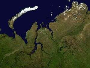
The Gyda Peninsula (Russian: Гыда́нский полуо́стров, romanized: Gydansky poluostrov) is a geographical feature of the Siberian coast in the Kara Sea. It takes its name from the river Gyda, that flows on the peninsula. It is roughly 400 km long and 360 km wide. This wide peninsula lies between the estuaries of the Ob (Gulf of Ob) and Yenisei Rivers (Yenisei Gulf). The southwestern corner of the peninsula is limited by the Taz Estuary. The climate in the whole area of the peninsula is arctic and harsh.
| Гыда́нский полуостров | |
|---|---|
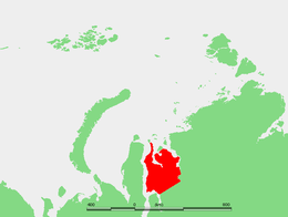 Location of the Gyda Peninsula. | |
| Geography | |
| Location | Far North |
| Coordinates | 70°N 79°E |
| Adjacent bodies of water | Gulf of Ob Kara Sea Yenisei Gulf |
| Area | 160,000 km2 (62,000 sq mi) |
| Length | 400 km (250 mi) |
| Width | 360 km (224 mi) |
| Highest elevation | 1,125 m (3,691 ft) |
| Administration | |
| Federal subject | Yamal-Nenets autonomous district |
Geography
The Gyda Peninsula is mostly flat, with numerous lakes and rivers. River Tanama has its sources in the peninsula.[1] Its ground consists of permafrost and is covered by tundra.
This peninsula has a few arms or subpeninsulas extending northwards into the Kara Sea, where there are some large islands off its shores, including Oleniy, Shokalsky and Vilkitsky Islands. There are two bays in its northern coast, narrow and deep Khalmyer Bay and smaller Yuratski Bay. The peninsula formed between the Khalmyer Bay and neighbouring Yuratski Bay is known as the Mamonta Peninsula (Russian: Полуостров Мамонта; Poluostrov Mamonta, meaning 'Mammoth Peninsula')[2] and the narrow peninsula in the NW formed between this bay and the neighbouring Gulf of Ob is known as the Yavay Peninsula (Russian: полуостров Явай; Poluostrov Yavay).
The Gyda Peninsula is located in the Yamal-Nenets autonomous district administrative region of the Russian Federation.[3] It appears also in the genitive as Gydansky or Gydanskiy Peninsula in many common maps in English.
Archaeological site
A notable archeological find from the peninsula is a mammoth skeleton, now housed in a zoological museum in Saint Petersburg.[4]
Environmental protection
In 1996 the northernmost 8 782 km² was declared a nature reserve (zapovednik), with a general ban on traffic[5]. The reserve Gyda Nature Reserve was administered from the region capital Tazovsky. 10 December 2019 the protected area was changed into a national park[6].
Petroleum
The fossil gas company PAO Novatek has since 2019 had permission for gas extraction from a major part of the peninsula[7][8]. In 2020 the company presented plans for construction of a major port on the Gulf of Ob for gas shipment. The port is called Utrenneye[9][10][11].
References
- Танама, Great Soviet Encyclopedia in 30 vols. / Ch. ed. A.M. Prokhorov - 3rd ed. - M, 1969-1978.
- Попов С.В., Троицкий В.А. Топонимика морей советской Арктики. — Л: Географическое общество СССР, 1972. — p. 316
- Yamalo-Nenets administration information
- Mammoth
- "Гыданский государственный природный заповедник" (in Russian).
- "Постановление правительства Российской Федерации от 10.12.2019 №1632" (ru).
- "Novatek adds several trillion cubic meters to its Arctic reserves". BarentsObserver. 8 January 2020.
- "Our assets". Novatek. Retrieved 29 April 2020.
- "Here comes Russia's next grand Arctic seaport". BarentsObserver. 12 June 2019.
- "New Arctic terminal will be built twice bigger than planned". BarentsObserver. 16 April 2020.
- "Arctic LNG 2 is another LNG production-related project of NOVATEK". Novatek. Retrieved 29 April 2020.
| Authority control |
|
|---|