Ria
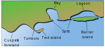
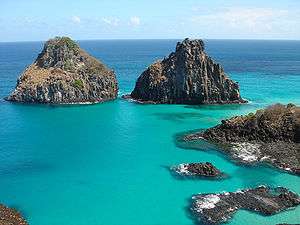
A ria (/ˈriːə/)[1] is a coastal inlet formed by the partial submergence of an unglaciated river valley. It is a drowned river valley that remains open to the sea. Typically, rias have a dendritic, treelike outline although they can be straight and without significant branches. This pattern is inherited from the dendritic drainage pattern of the flooded river valley. The drowning of river valleys along a stretch of coast and formation of rias results in an extremely irregular and indented coastline. Often, there are naturally-occurring islands, which are summits of partly submerged, preexisting hill peaks. (Islands may also be artificial, such as those constructed for the Chesapeake Bay Bridge-Tunnel.)
_V2.jpg)
A ria coast is a coastline having several parallel rias separated by prominent ridges, extending a distance inland.[2][3][4] The sea level change that caused the submergence of a river valley may be either eustatic (where global sea levels rise), or isostatic (where the local land sinks). The result is often a very large estuary at the mouth of a relatively insignificant river (or else sediments would quickly fill the ria). The Kingsbridge Estuary in Devon, England, is an extreme example of a ria forming an estuary disproportionate to the size of its river; no significant river flows into it at all, only a number of small streams.[4]
Etymology
| Look up ria in Wiktionary, the free dictionary. |
The word ria comes from Portuguese ria or Galician ría, which is related to Spanish and Galician río and Portuguese rio (river). Rias are present all along the Galician coast in Spain. As originally defined, the term was restricted to drowned river valleys cut parallel to the structure of the country rock that was at right angles to the coastline. However, the definition of ria was later expanded to other flooded river valleys regardless of the structure of the country rock.
For a period of time, European geomorphologists[5] regarded rias to include any broad estuarine river mouth, including fjords. These are long, narrow inlets with steep sides or cliffs, created in a valley carved by glacial activity. In the 21st century, however, the preferred usage of ria by geologists and geomorphologists is to refer solely to drowned unglaciated river valleys. It therefore excludes fjords by definition, since fjords are products of glaciation.[2][3][4]
Locations
Europe
- Portugal: has no rias as such: the Ria de Aveiro in Aveiro, and Ria Formosa in Eastern Algarve[6] are actually lagoons.
- Atlantic coast of Spain
- Galicia:
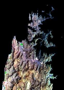
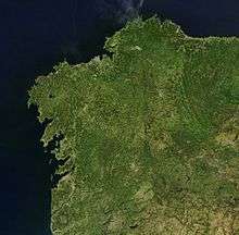 A satellite view of Galicia
- The Rias Baixas, including the Ria of Vigo, Ria of Pontevedra, Ria de Arousa, Ria of Muros and Noia, Ria of Corcubion, Cee and Ria de Aldán.
- The Rias Altas, including the Ria of Corunna, Ria of Ares and Betanzos, Ria of Cedeira, Ria of O Barqueiro, Ria of Ferrol, Ria of Ortigueira, Ria of Viveiro, Ria of Foz and Ria of Ribadeo.
- Asturias: Ria of Avilés, Ria of Ribadeo, Ria of Navia, Ria of Villaviciosa, Ria of Ribadesella, Ria of Llanes, Ria of Tina Mayor.
- Cantabria: Ria of Tina Mayor, Ria of Tina Menor, Ría de San Vicente de la Barquera, Ría of la Rabia, Ría of San Martín de la Arena, Ría of Mogro, Ría of Solía, Ría of Carmen, Ría of Boo, Ría of Tijero, Ría of Cubas, Ría de Ajo, Ría of Cabo Quejo, Ría of Treto, Ría of Oriñón.
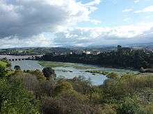 Ria of San Vicente de la Barquera in Cantabria, Spain
 - Basque Country: Ria of Bilbao, mouth of the rivers Nervión, Ibaizabal, and Cadagua.
- Andalusia: Ria of Carreras, Ria of Huelva at the mouth of the rivers Odiel and Tinto.
- Brittany: The rias in northern Brittany are called Abers: Aber Wrac'h (48.599807°N 4.549376°W), Aber Benoît (48.562747°N 4.579905°W), Aber Ildut (48.472649°N 4.749602°W). The Roadstead of Brest also includes several rias.
- Ireland: Bantry Bay located on the southwest coast of Ireland is an example of an Irish ria.
- Wales: Milford Haven in Pembrokeshire is a ria.
- England: The south coast of England is a submergent coastline which contains many rias, including Southampton Water, Poole Harbour, the estuaries of the Exe, Teign and Dart, then Kingsbridge Estuary, Plymouth Sound in Devon, and the estuaries of the River Fowey, River Fal and Helford River in Cornwall. On the north coast is the River Camel and the River Taw. In Essex is the Blackwater River and River Crouch. The River Severn also forms a large ria.
- Croatia: Lim, Rijeka Dubrovačka
- Montenegro: The Bay of Kotor
- Italy: The Fiordo di Furore on the Amalfi Coast in Campania is a ria, despite its name.
- Malta: Grand Harbour and Marsamxett Harbour
Africa
- Kenya: Kilindini Harbour, which is a deep channel between Mombasa island and South Coast mainland, is a ria.
Asia
- Sanriku Coast: North Japan, east coast of Honshū Island (main island). Sendai city, Miyagi Prefecture and Iwate Prefecture are included.
- Ago Coast in Shima (Mie Prefecture) is a Ria coast, well known for its pearls.
- Coasts on western, southern sides of the Korean Peninsula: Rias formed by sea level rising after Ice Age.
- The Chinese east coast, from the Guangdong province (Hong Kong coastlines included) to Shanghai.
- The Musandam Peninsula in Oman, comprising the southern shore of the Strait of Hormuz.
Oceania
- Papua New Guinea: Rias formed by eroded volcanic lava flow are found all around the town of Tufi at Cape Nelson, in Papua New Guinea's Oro Province.
- Australia: The east coast of Australia features several rias around Sydney, including Georges River, Port Hacking, and Port Jackson, which includes Sydney Harbour. There are many examples in Western Australia, including the Swan River around Perth and several rivers in the west Kimberley region.
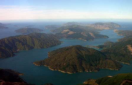
- New Zealand: Rias of various scales abound on the eastern shores of the upper North Island. On the west coast, in contrast, they are fewer but larger. Kaipara Harbour is the country's largest, and the Hokianga Harbour, further north, is of historical significance to the native Māori people. The Marlborough Sounds at the northern tip of the South Island form a large network of rias.
- Hawaii: Pearl Harbor on Oahu is a ria, with the branches of West Loch, Middle Loch, East Loch, and Southeast Loch formed by the submerged drainages of Waikele, Waiau, Waimalu, and Hālawa streams respectively.
North America
- United States: Narragansett Bay, New York Harbor, Delaware Bay, Indian River Bay, the Chesapeake Bay, and Charleston Harbor are rias on the East Coast. Willapa Bay and Grays Harbor in Washington and San Francisco Bay in California on the West Coast are also rias.
- Canada: Charlottetown Harbour, Prince Edward Island
South America
- Argentina: Patagonia has the Deseado ria, on the coast of Santa Cruz Province, on the Atlantic Ocean. Also, the "bay" that is Bahía Blanca is a ría.
Consequences
Ria can amplify the effects of tsunamis, as demonstrated in the seismicity of the Sanriku coast, most recently in the 2011 Tōhoku earthquake and tsunami.
See also
References
- "ria". Oxford English Dictionary (3rd ed.). Oxford University Press. September 2005. (Subscription or UK public library membership required.)
- Cotton, C.A. (1956). "Rias Sensu Stricto and Sensu Lato". The Geographical Journal. 122 (3): 360–364. doi:10.2307/1791018.
- Goudie, A. (2004) Encyclopedia of Geomorphology. Routledge. London, England.
- Bird, E.C.F. (2008) Coastal Geomorphology: An Introduction, 2nd ed. John Wiley and Sons Ltd. West Sussex, England.
- Gulliver, F.P. (1899). "Shoreline Topography". Proceedings of the American Academy of Arts and Sciences. 34 (8): 151–258. doi:10.2307/20020880.
- Michael J. Kennish; Hans W. Paerl (15 June 2010). Coastal Lagoons: Critical Habitats of Environmental Change. CRC Press. pp. 361–. ISBN 978-1-4200-8831-1.
Further reading
- Perillo, Gerardo, Geomorphology and Sedimentology of Estuaries, Volume 53. pp. 17–47. Elsevier Science (1995) ISBN 9780080532493
- von Richthofen, F. Fuhrer fur Forschungsreisende ("Guide for Explorers"), pp. 308–310. Berlin, Oppenheim (1886)