Queen Elizabeth Islands
The Queen Elizabeth Islands (French: Îles de la Reine-Élisabeth; formerly Parry Islands or Parry Archipelago) are the northernmost cluster of islands in Canada's Arctic Archipelago, split between Nunavut and the Northwest Territories in Northern Canada. The Queen Elizabeth Islands contain approximately 14% of the global glacier and ice cap area.[1] (excluding the inland and shelf ice sheets of Greenland and Antarctica).
_Islands%2C_northern_Canada.png)
Geography
The islands, together 419,061 km2 (161,800 sq mi)[2] in area, were renamed as a group after Elizabeth II on her coronation as Queen of Canada in 1953. The islands cover an area approximating to the shape of a right triangle, bounded by the Nares Strait on the east, Parry Channel on the south and the Arctic Ocean to the north and west. Most are uninhabited although the Natural Resources Canada's Climate Change Geoscience Program Earth Sciences Sector (ESS), has monitors on the islands.[3] In 1969 Panarctic Oils, now part of Suncor Energy began operating exploration oil wells in the Franklinian and Sverdrup basins and planned on establishing its resource base in the Queen Elizabeth Islands. It ceased production in the 1970s. At the 2013 GeoConvention the Arctic Islands region were called Canada's perpetual "last petroleum exploration frontier". Hogg and Enachescu argued that the development and implementation of advanced marine and land seismic technologies in Alaska, Northern Europe and Siberia could be modified for use in the Queen Elizabeth Islands.[4]
First sighted by Europeans in 1616, the Queen Elizabeth Islands were not fully explored and charted until the British Northwest Passage expeditions and later Norwegian exploration of the 19th century.
These islands were known as the Parry Archipelago for over 130 years. They were first named after British Arctic explorer Sir William Parry, who sailed there in 1820, aboard the Hecla. Since the renaming of the archipelago in 1953, the term Parry Islands continued to be used for its southwestern part (less Ellesmere Island and the Sverdrup Islands). The regional break down of the archipelago is therefore as follows:
- Ellesmere Island
- Sverdrup Islands
- Parry Islands
Ellesmere Island is the northernmost and by far the largest. The Sverdrup Islands are located west of Ellesmere Island and north of Norwegian Bay. The remaining islands further south and west, but north of the Parry Channel (Lancaster Sound, Viscount Melville Sound and McClure Strait), have been carrying the name Parry Islands, which name until 1953 had also included the Sverdrup Islands and Ellesmere Island. South of Lancaster Sound, Viscount Melville Sound and M'Clure Strait are the remaining islands of the Arctic Archipelago.
Major islands
Many of the islands are among the largest in the world, the largest being Ellesmere Island. Other major islands include Amund Ringnes Island, Axel Heiberg Island, Bathurst Island, Borden Island, Cornwall Island, Cornwallis Island, Devon Island, Eglinton Island, Ellef Ringnes Island, Mackenzie King Island, Melville Island, and Prince Patrick Island.[2]
Smaller islands
Other smaller but notable islands include; Beechey Island (74°43′N 091°51′W), which held the graves of Petty Officer John Torrington, Royal Marine Private William Braine, and Able Seaman John Hartnell, three members of Sir John Franklin's crew who took part in his lost expedition,[5][6] Hans Island (80°49′41″N 066°27′35″W), a small, uninhabited barren knoll measuring 1.3 km2 (0.50 sq mi) whose ownership is disputed by Canada and Denmark,[7] the Cheyne Islands (76°18′22″N 097°31′12″W), three small (0.73 km2 (0.28 sq mi) together) islands that are Important Bird Area (#NU049) and a Key Migratory Bird Terrestrial Habitat site (NU site 5)[8] and Skraeling Island (78°54′42″N 075°37′58″W) an important archaeological site where Inuit (along with their ancestors the Dorset and Thule) and Norse artifacts have been found.[9] They consist of Silurian and Carboniferous rocks covered with tundra.
Population
With a population of less than 400, the islands are nearly uninhabited. There are only three permanently inhabited places in the islands. The two municipalities are the hamlets of Resolute (population 198 as of the 2016 census[10]), on Cornwallis Island, and Grise Fiord (population 129 as of the 2016 census[11]), on Ellesmere Island. Alert, is a weather station staffed by Environment and Climate Change Canada, a Global Atmosphere Watch (GAW) atmosphere monitoring laboratory on Ellesmere Island and has several temporary inhabitants due to the co-located CFS Alert. Eureka, a small research base on Ellesmere Island, has a population of zero but at least 8 staff on a continuous rotational basis.
Abandoned Permanent Settlement Seasonally Occupied
| Name | Image | Type | Island | Population | Established | Coordinates | Notes |
|---|---|---|---|---|---|---|---|
| Alert |  | Weather station, Canadian Forces base (CFS Alert), airport (Alert Airport) | Ellesmere | 5 | 1950[Note 1] |
| |
| Alexandra Fiord | scientific research station | Ellesmere | 0 | 1953 |
| ||
| Camp Hazen | Warden station | Ellesmere | 0 | 1957 |
| ||
| Craig Harbour | 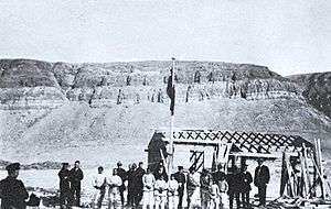 | Royal Canadian Mounted Police (RCMP) detachment | Ellesmere | 0 | 1922 |
| |
| Dundas Harbour | 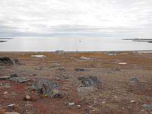 | Outpost, RCMP detachment | Devon | 0 |
| ||
| Eureka |  | Weather station, research station, aerodrome (Eureka Aerodrome) | Ellesmere | 0 | 1947 |
| |
| Flashline Mars Arctic Research Station | 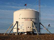 | Research station | Devon | 0 | 1999 |
| |
| Fort Conger | 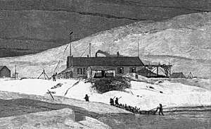 | Research station | Ellesmere | 0 | 1883 |
| |
| Grise Fiord | 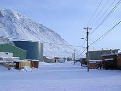 | Hamlet, airport (Grise Fiord Airport) | Ellesmere | 129 | 1953 | 76°25′N 82°53′W |
|
| Isachsen | 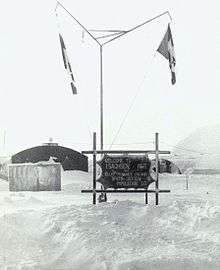 | Weather station, research station | Ellef Ringnes | 0 | 1948 | 78°46′N 103°29′W |
|
| McGill Arctic Research Station | Research station | Axel Heiberg | 0 | 1959 | 79°20′N 91°58′W |
| |
| Mould Bay | Weather station | Prince Patrick | 0 | 1948 | 76°14′N 119°19′W |
| |
| Resolute | 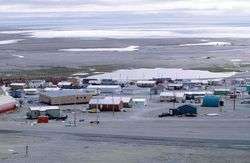 | Hamlet, airport (Resolute Bay Airport) | Cornwallis | 229 | 1947 |
|
Formerly manned stations were Mould Bay on Prince Patrick Island, Isachsen on Ellef Ringnes Island, and Fort Conger on Ellesmere Island.
Abandoned settlements are Dundas Harbour on Devon Island and Craig Harbour on Ellesmere Island.
Administration
Until 1999, the Queen Elizabeth Islands were part of the Baffin Region of the Northwest Territories.
With the creation of Nunavut in 1999 all islands and fractions of islands of the archipelago east of the 110th meridian west became part of the Qikiqtaaluk Region of the new territory, which was the major portion of the archipelago. The rest remained with the now-reduced Northwest Territories. Borden Island, Mackenzie King Island and Melville Island were divided between the two territories.
Prince Patrick Island, Eglinton Island and Emerald Island are the only notable islands that are now completely part of the Northwest Territories.
Below the level of the territory, there is the municipal level of administration. On that level, there are only two municipalities, Resolute and Grise Fiord, with an aggregate area of 450 km2 (170 sq mi) (0.11 percent of the area of the Queen Elizabeth Islands), but with most of the population of the archipelago (370 out of 375). The remaining 99.89 percent are unincorporated area, with a census 2006 population of five, all in Alert.
Overview of the islands
According to the Atlas of Canada there are 34 larger and 2,092 smaller islands in the archipelago.[2] With the exception of Ellesmere Island, they fall into two groups, the Sverdrup Islands and the Parry Islands:
| Island | sub- group | Territory | Peak | Height m | Height ft | Area km² | Area sq mi | Rank Canada | Rank World | Coordinates |
|---|---|---|---|---|---|---|---|---|---|---|
| Alexander[14] | Parry | NU | average elevation | 60–180 | 200–590 | 484 | 187 | 66 | 75°52′N 102°37′W | |
| Amund Ringnes[15] | Sverdrup | NU | ridge | 265 | 869 | 5,255 | 2,029 | 25 | 111 | 77°53′N 095°30′W |
| Axel Heiberg[16] | Sverdrup | NU | Outlook Peak | 2,210 | 7,250 | 43,178 | 16,671 | 7 | 32 | 79°26′N 090°46′W |
| Baillie-Hamilton Island[17] | Parry | NU | 200 | 660 | 290 | 110 | 91 | 75°53′N 094°35′W | ||
| Bathurst[18] | Parry | NU | Stokes Mountain | 412 | 1,352 | 16,042 | 6,194 | 13 | 54 | 75°46′N 099°47′W |
| Borden[19] | Parry | NU/NT | 150 | 490 | 2,794 | 1,079 | 30 | 170 | 78°33′N 111°10′W | |
| Brock[20] | Parry | NT | 67 | 220 | 764 | 295 | 58 | 383 | 77°51′N 114°27′W | |
| Buckingham Island[21] | Parry | NU | Mount Windsor | 150 | 490 | 137 | 53 | 137 | 77°12′N 091°00′W | |
| Byam Martin[22] | Parry | NU | 153 | 502 | 1,150 | 440 | 42 | 294 | 75°12′N 104°17′W | |
| Cameron[23] | Parry | NU | Mount Wilmot | 1,059 | 409 | 46 | 312 | 77°48′N 101°51′W | ||
| Coburg Island[24] | Parry | NU | 800 | 2,600 | 411 | 159 | 83 | 75°57′N 079°18′W | ||
| Cornwall[25] | Sverdrup | NU | McLeod Peak | 400 | 1,300 | 2,358 | 910 | 31 | 184 | 77°37′N 094°52′W |
| Cornwallis[26] | Parry | NU | 343 | 1,125 | 6,995 | 2,701 | 21 | 96 | 75°05′N 095°00′W | |
| Devon[27] | Parry | NU | Devon Ice Cap | 1,920 | 6,300 | 55,247 | 21,331 | 6 | 27 | 75°08′N 087°51′W |
| Eglinton[28] | Parry | NT | 200 | 660 | 1,541 | 595 | 36 | 249 | 75°46′N 118°27′W | |
| Ellef Ringnes[29] | Sverdrup | NU | Isachsen Dome | 260 | 850 | 11,295 | 4,361 | 16 | 69 | 78°37′N 101°56′W |
| Ellesmere[30] | NU | Barbeau Peak | 2,616 | 8,583 | 196,236 | 75,767 | 3 | 10 | 80°10′N 079°05′W | |
| Emerald Isle[31] | Parry | NT | 150 | 490 | 549 | 212 | 63 | 466 | 76°48′N 114°07′W | |
| Graham[32] | Sverdrup | NU | 175 | 574 | 1,378 | 532 | 38 | 265 | 77°26′N 090°30′W | |
| Griffith Island[33] | Parry | NU | 189 | 73 | 110 | 74°35′N 095°30′W | ||||
| Helena Island[34] | Parry | NU | average in southern hills | 220 | 720 | 327 | 126 | 85 | 76°40′N 101°00′W | |
| Hoved Island[35] | Parry | NU | 158 | 61 | 125 | 77°32′N 085°09′W | ||||
| Île Vanier[36] | Parry | NU | 200 | 660 | 1,126 | 435 | 44 | 298 | 76°10′N 103°15′W | |
| King Christian[37] | Sverdrup | NU | King Christian Mountain | 165 | 541 | 645 | 249 | 60 | 420 | 77°45′N 102°00′W |
| Little Cornwallis Island[38] | Parry | NU | 412 | 159 | 75 | 75°30′N 096°30′W | ||||
| Lougheed[39] | Parry | NU | 60–110 | 200–360 | 1,308 | 505 | 41 | 273 | 77°24′N 105°15′W | |
| Lowther Island[40] | Parry | NU | raised beach | 106.5 | 349 | 145 | 56 | 133 | 74°33′N 097°30′W | |
| Mackenzie King[41] | Parry | NU/NT | Castel Butte | 300 | 980 | 5,048 | 1,949 | 26 | 115 | 77°43′N 111°57′W |
| Massey[42] | Parry | NU | 210 | 690 | 432 | 167 | 71 | 75°59′N 102°58′W | ||
| Meighen[43] | Sverdrup | NU | 260 | 850 | 955 | 369 | 50 | 337 | 79°59′N 099°30′W | |
| Melville[44] | Parry | NU/NT | 776 | 2,546 | 42,149 | 16,274 | 8 | 33 | 75°30′N 111°30′W | |
| North Kent[45] | Parry | NU | 600 | 2,000 | 590 | 230 | 62 | 453 | 76°40′N 090°15′W | |
| Prince Patrick[46] | Parry | NT | 279 | 915 | 15,848 | 6,119 | 14 | 55 | 76°45′N 119°30′W | |
| Stor Island[47] | Sverdrup | NU | 500 | 1,600 | 313 | 121 | 87 | 78°59′N 085°50′W | ||
| remaining 2,092 islands[2] | NU/NT | 2,321 | 896 | ... | ... | |||||
| Queen Elizabeth[2] | NU/NT | Barbeau Peak | 2,616 | 8,583 | 419,061 | 161,800 | ... | ... | 78°05′N 095°10′W |
Glaciers and ice caps
In 2000 it was estimated that the Queen Elizabeth Islands were covered by about 104,000 km2 (40,000 sq mi) glaciers that represent c.14% of all glaciers and ice caps in the world.[1] According to a 2011 report, the surface mass balance of four, the Devon Ice Cap measured 1,699 km2 (656 sq mi) (northwest sector only); the Meighen Ice Cap measured 75 km2 (29 sq mi); the Melville South Ice Cap measured 52 km2 (20 sq mi) and the White Glacier, Axel Heiberg Island glacier was 39 km2 (15 sq mi).[1] The size of these glaciers has been measured since 1961 and their results published in such distinguished journals as the International Glaciological Society's Annals of Glaciology.[1][48][49]
Of the four ice caps that the federal government's NRCan's Climate Change Geoscience Program Earth Sciences Sector (ESS), monitors onsite in the Canadian High Arctic, three are in the Queen Elizabeth Islands: Devon, Meighen and Melville.[3] In a memo to Earth Sciences Sector (ESS) in Canada's High Arctic indicates that shrinking of ice caps started in the late 1980s, and has accelerated rapidly since 2005," says an October 2013 memo to NRCan's deputy minister, who reports to federal Natural Resources Minister Joe Oliver. The increased melt rate was confirmed by University of California, Irvine in 2017.[50]
Computer analysis of a glacier inventory of Axel Heiberg Island was undertaken in the 1960s.[51] Later inventories of the World Glacier Monitoring Service under the direction of Fritz Müller, who worked on glacier inventories internationally, included the Axel Heiberg Island glacier.[52]
Other glaciers and ice caps in the Queen Elizabeth Islands include the Agassiz Ice Cap, Benedict Glacier, Disraeli Glacier, Eugenie Glacier, Gull Glacier, Parrish Glacier, Sven Hedin Glacier and the Turnabout Glacier.
References
- Sharp, Martin; Burgess, David O.; Cogley, J. Graham; Ecclestone, Miles; Labine, Claude; Wolken, Gabriel J. (9 June 2011). "Extreme melt on Canada's Arctic ice caps in the 21st century" (PDF). Geophysical Research Letters. 38 (11): n/a. Bibcode:2011GeoRL..3811501S. doi:10.1029/2011GL047381. Retrieved 20 February 2014.
- "Sea islands". Atlas of Canada. Archived from the original on January 22, 2013. Retrieved January 22, 2013.
- Fekete, Jason (18 February 2014). "Canada's Arctic ice caps melting rapidly since 2005, according to documents". Postmedia. Retrieved 22 February 2014.
- Hogg, John R.; Enachescu, Michael E (2013), Reviving Exploration in the Arctic Islands: Opportunities and Challenges from an Operator's Perspective, Calgary, Alberta
- Researches for Sir John Franklin
- Franklin timeline Archived April 8, 2012, at the Wayback Machine
- "Greenland, Canada squabbling over pet rock". Archived from the original on 2008-06-05. Retrieved 2009-08-17.
- Cheyne Islands Archived March 19, 2012, at the Wayback Machine
- "Vikings: the Arctic's first European visitors". Archived from the original on 2006-11-21. Retrieved 2009-08-17.
- "Census Profile, 2016 Census - Resolute". Statistics Canada. Retrieved 2017-03-03.
- "Census Profile, 2016 Census - Grise Fiord". Statistics Canada. Retrieved 2017-03-03.
- "Grise Fiord Community History". The Qikiqtani Truth Commission. Archived from the original on 6 January 2015. Retrieved 27 April 2015.
- "Dundas Harbour - August 17th, 2013". Polar Trec. Retrieved 27 April 2015.
- "Alexander Island". Archived from the original on 2010-12-23. Retrieved 2010-12-23.CS1 maint: BOT: original-url status unknown (link) at oceandots.com
- "Amund Ringnes Island". oceandots.com. Archived from the original on December 23, 2010. Retrieved May 28, 2008.
- "Axel Heiberg Island". Archived from the original on 2010-12-23. Retrieved 2010-12-23.CS1 maint: BOT: original-url status unknown (link) at oceandots.com
- "Baillie-Hamilton Island". oceandots.com. Archived from the original on December 23, 2010. Retrieved May 6, 2008.
- Bathurst Island at Bivouac.com
- "Borden Island". Archived from the original on 2010-12-23. Retrieved 2010-12-23.CS1 maint: BOT: original-url status unknown (link) at oceandots.com
- "Brock Island". Archived from the original on 2010-12-23. Retrieved 2010-12-23.CS1 maint: BOT: original-url status unknown (link) at oceandots.com
- Buckingham Island at the Atlas of Canada
- "Byam Martin Island". Archived from the original on 2010-12-23. Retrieved 2009-03-14.CS1 maint: BOT: original-url status unknown (link) at oceandots.com
- "Cameron Island". Archived from the original on 2010-12-23. Retrieved 2009-08-17.CS1 maint: BOT: original-url status unknown (link) at oceandots.com
- "Coburg Island". Archived from the original on 2010-12-23. Retrieved 2009-08-20.CS1 maint: BOT: original-url status unknown (link) at oceandots.com
- "Cornwall Island". Archived from the original on 2010-12-23. Retrieved 2009-08-17.CS1 maint: BOT: original-url status unknown (link) at oceandots.com
- "Cornwallis Island". Archived from the original on 2010-12-23. Retrieved 2009-08-17.CS1 maint: BOT: original-url status unknown (link) at oceandots.com
- "Devon Island". oceandots.com. Archived from the original on December 23, 2010. Retrieved June 26, 2008.
- "Eglinton Island". Archived from the original on 2010-12-23. Retrieved 2009-08-17.CS1 maint: BOT: original-url status unknown (link) at oceandots.com
- "Ellef Ringnes Island". Archived from the original on 2010-12-23. Retrieved 2009-08-17.CS1 maint: BOT: original-url status unknown (link) at oceandots.com
- "Ellesmere Island". Archived from the original on 2010-12-23. Retrieved 2009-01-15. at oceandots.com
- "Emerald Isle". Archived from the original on 2010-12-23. Retrieved 2009-08-17.CS1 maint: BOT: original-url status unknown (link) at oceandots.com
- "Graham Island". oceandots.com. Archived from the original on December 23, 2010. Retrieved April 10, 2008.
- Griffith Island at the Atlas of Canada
- "Helena Island". Archived from the original on 2010-12-23. Retrieved 2009-08-20.CS1 maint: BOT: original-url status unknown (link) at oceandots.com
- Hoved Island at the Atlas of Canada
- "Île Vanier". Archived from the original on 2010-12-23. Retrieved 2009-08-17.CS1 maint: BOT: original-url status unknown (link) at oceandots.com
- "King Christian Island". oceandots.com. Archived from the original on December 23, 2010. Retrieved May 12, 2008.
- "Little Cornwallis Island". Archived from the original on 2010-12-23. Retrieved 2009-08-20.CS1 maint: BOT: original-url status unknown (link) at oceandots.com
- "Lougheed Island". Archived from the original on 2010-12-23. Retrieved 2009-08-17.CS1 maint: BOT: original-url status unknown (link) at oceandots.com
- Lowther Island at the Atlas of Canada
- "Mackenzie King Island". Archived from the original on 2010-12-23. Retrieved 2009-08-17.CS1 maint: BOT: original-url status unknown (link) at oceandots.com
- "Massey Island". Archived from the original on 2010-12-23. Retrieved 2009-08-17.CS1 maint: BOT: original-url status unknown (link) at oceandots.com
- Meighen Island at arctic.uoguelph.ca
- "Melville Island". Archived from the original on 2010-12-23. Retrieved 2009-08-17.CS1 maint: BOT: original-url status unknown (link) at oceandots.com
- "North Kent Island". Archived from the original on 2010-12-23. Retrieved 2009-08-17.CS1 maint: BOT: original-url status unknown (link) at oceandots.com
- Prince Patrick Island at peakbagger.com
- "Stor Island". oceandots.com. Archived from the original on December 23, 2010. Retrieved April 13, 2008.
- Cogley, J. G.; Adams, W. P.; Ecclestone, M. A.; Jung‐Rothenhausler, F.; Ommaney, C. S. L. (1996). "Mass balance of White Glacier, Axel Heiberg Island, NWT, Canada, 1960–91". Journal of Glaciology. 42 (142): 548–563. Bibcode:1996JGlac..42..548C. doi:10.1017/S0022143000003531.
- Koerner, R. M. (2005). "Mass balance of glaciers in the Queen Elizabeth Islands, Nunavut, Canada". Annals of Glaciology. 42 (1): 417–423. Bibcode:2005AnGla..42..417K. doi:10.3189/172756405781813122.
- "Canadian glaciers now major contributor to sea level change, UCI study shows". UCI News. 14 February 2017. Retrieved 20 February 2017.
- Ommanney, C. S.L.; Goodman, R. H.; Müller, Fritz (1969). "Computer Analysis of a Glacier Inventory of Axel Heiberg Island: Canadian Arctic Archipelago". Hydrological Sciences Journal. 14: 19–28. doi:10.1080/02626666909493698.
- Lang, Herbert (21 Dec 2009) [1981]. "Obituary Fritz Muller". Hydrological Sciences Bulletin. Zürich, Switzerland. 26 (3): 332–333. doi:10.1080/02626668109490893.
- The weather station was established in 1950 and the military station was established in 1958
External links
- "Bathurst Island". Archived from the original on 2010-12-23. Retrieved 2010-08-25. at oceandots.com
- Cornwall Island at oceandots.com
- Meighen Island at the Wayback Machine (archived December 23, 2010) at oceandots.com
- "Prince Patrick Island". Archived from the original on 2010-12-23. Retrieved 2009-08-17.CS1 maint: BOT: original-url status unknown (link) at oceandots.com