Bight (geography)
In geography, a bight is a bend or curve in a coastline, river, or other geographical feature.[1] It typically indicates a large, open bay, often only slightly receding.[2] It is distinguished from a sound by being shallower. Traditionally, explorers defined a bight as a bay that could be sailed out of on a single tack in a square-rigged sailing vessel, regardless of the direction of the wind (typically meaning the apex of the bight is less than 25 degrees from the edges).
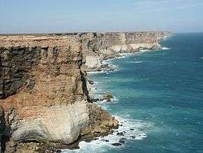
A stretch of coastline of the Great Australian Bight
The term is derived from Old English byht (“bend, angle, corner; bay, bight”) and is not etymologically related to "bite" (Old English bītan).
Notable bights
- Bay of Campeche
- Bay of Plenty
- Bight of Benin
- Bight of Biafra or Bight of Bonny
- Canterbury Bight
- Flemish Bight
- German Bight or Heligoland Bight
- Great Australian Bight
- McKenzie Bight
- Mecklenburg Bight
- Mid-Atlantic Bight
- New York Bight
- Cameron Sound
- North Taranaki Bight
- Robson Bight
- Santa Monica Bay
- South Taranaki Bight
- Southern Bight
- Southern California Bight
- Trinity Bight, Newfoundland and Labrador
References
- "Definition of bight in English". Oxford Dictionary. Oxford University Press. Retrieved 9 August 2016.
- "What is a bight?". National Ocean Service. National Oceanic and Atmospheric Administration. Retrieved 9 August 2016.
This article is issued from Wikipedia. The text is licensed under Creative Commons - Attribution - Sharealike. Additional terms may apply for the media files.