Şile
Şile is a city and district in Istanbul, Turkey. According to the 2007 census, the population of the district was 25,169, of which 9,831 lived in the city of Şile, 2,096 in the nearby town of Ağva (Yeşilçay) and 13,242 in surrounding villages.[3] However, between June and September, the population rapidly increases because of the many residents of Istanbul who have summer houses in Şile.
Şile | |
|---|---|
district | |
 Panoramic view on Şile | |
 Location of Şile in Istanbul | |
 Şile Location of Şile in Istanbul | |
| Coordinates: 41°10′35″N 29°36′46″E | |
| Country | Turkey |
| City | Istanbul |
| Government | |
| • Mayor | İlhan Ocaklı (AKP) |
| • Governor | İbrahim Süha Karaboran |
| Area | |
| • District | 915.58 km2 (353.51 sq mi) |
| Population (2012)[2] | |
| • Urban | 13,260 |
| • District | 30,218 |
| • District density | 33/km2 (85/sq mi) |
| Time zone | UTC+2 (EET) |
| • Summer (DST) | UTC+3 (EEST) |
| Area code(s) | 0-216 |
| Website | www |
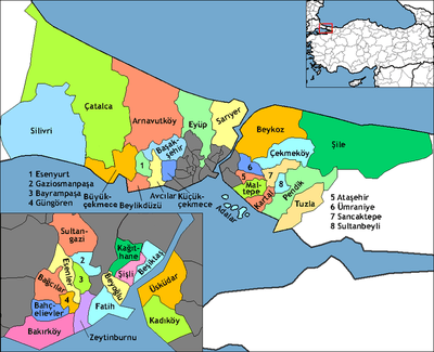
The district of Şile is part of the province (il) of Istanbul, and the municipality of Şile is part of the metropolitan government (büyükşehir belediyesi) of Istanbul. Bordering Şile is the province of Kocaeli (districts of Gebze, Körfez, Derince, Kandıra) to the east and south, and Istanbul districts of Pendik to the south, Çekmeköy to the southwest, and Beykoz to the west.[4] The boundaries of Şile were expanded by the addition of the village of Esenceli from Beykoz district in 1987. Şile consists of Şile, Yeşilvadi and Teke subdistricts, and 58 villages. The mayor is Can Tabakoğlu (AKP). Popular resort Ağva is also a part of Şile.
History
The word şile means marjoram in Turkish.[5] The word's etymology is said to be Greek.[6]
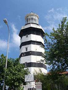
There has been a fishing village here since 700 BC and a lighthouse since the Ottoman period. According to the Ottoman General Census of 1881/82-1893, the kaza of Şile had a total population of 16.770, consisting of 10.314 Muslims, 6.447 Greeks, 3 Armenians and 6 foreign citizens.[7]
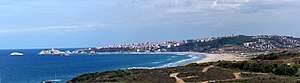
Today, Şile is a beach resort, popular with people who want a resort atmosphere without the expense of travelling to the Mediterranean Sea. Şile is about an hour's drive from the city and was always a retreat from the city. During Turkey's economic boom of the 1990s, a great many summer homes and holiday villages were built for the city's middle class, especially after the 1999 earthquake damaged the Marmara coast. There is a small but sandy beach, a little harbour of fishing boats, dense forest behind and a quiet pleasant atmosphere during the week. At weekends though, and especially on a hot summer Sunday, Şile is crowded with day-trippers from the poorer districts of the city, who come packed into minibuses and vans to picnic and play football. There are a number of bars and restaurants with sea views, especially in the little park around the lighthouse.
Features
Şile is famous for its beaches. However, it is at the northernmost point of Istanbul and thus shares the same sea conditions as other Black Sea towns where strong sea undercurrents can be dangerous to inexperienced swimmers. Beachgoers drown here annually on a regular basis.[8] The north-facing Black Sea has a much shorter holiday season than the Aegean, the Mediterranean or even the Marmara, due to the cold winters.
Şile Castle (Turkish: Şile Kalesi) is a 14th-century Genoese castle on an island in Şile.[9] The castle was renovated in 2015, sparking criticism that the work had made it resemble the cartoon character SpongeBob SquarePants or an illustration from the video game Minecraft.[10]
The tomb of a Muslim saint, Kum Baba, is on a tree-covered hill above Şile.[11] Along the coast near Şile, in the village of Kızılcaköy, is a cave which, according to a local myth, is said to be the scene of events in the Anabasis of Xenophon.
Şile is also known for Şile cloth, a crimped-looking, light, see-through cotton fabric, made on the Şile coast, sold in many shops in the town and sent to the bazaars of Istanbul.[12] A fair is held in the town to promote Şile cloth every summer.
The largest campus of Işık University is located in Şile.
Transport
Şile is a part of Istanbul public transport system (İETT). There is a bus from Harem via Üsküdar (located at the Anatolian side of Istanbul) to Şile (İETT Lines 139 and 139A).
International relations
References
- Notes
- "Area of regions (including lakes), km²". Regional Statistics Database. Turkish Statistical Institute. 2002. Retrieved 2013-03-05.
- "Population of province/district centers and towns/villages by districts - 2012". Address Based Population Registration System (ABPRS) Database. Turkish Statistical Institute. Retrieved 2013-02-27.
- Şile Kaymakamlığı (Şile District Governor). Nüfus Durumu (Population Status). Web: Retrieved 26 June 2010.
- İstanbul Büyükşehir Belediyesi (Istanbul Metropolitan Municipality). İstanbul Şehir Rehberi (Istanbul City Guide). Web: Retrieved 26 June 2010.
- Türk Dil Kurumu. Büyük Türkçe Sözlük (Large Turkish Dictionary). http://tdkterim.gov.tr/bts/?kategori=verilst&kelime=%FEile Retrieved 26 June 2010.
- Hürel, page 301.
- Kemal Karpat (1985), Ottoman Population, 1830-1914, Demographic and Social Characteristics, The University of Wisconsin Press, p. 138-139
- Drownings in Şile
- The Rough Guide to Istanbul. 2015. London: Rough Guides Ltd.
- Historic Castle in Istanbul Turns into ‘SpongeBob’ after Restoration. 2015. Hurriyet Daily News (August 26).
- Şile Istanbul
- SuTowel
- Sources
- Hürel, Haldun. Semtleri, Mahalleri, Caddeleri ve Sokakları A'dan Z'ye İstanbul'un Alfabetik Öyküsü. İstanbul, 2008. ISBN 978-975-999-290-3.
External links
| Wikimedia Commons has media related to Şile. |
- Işık University (in English)
- Şile Municipality (in Turkish)
- Şile Port - Tourist Information (in Turkish)
- A firm manufacturing Şile bezi (in Turkish)
- Şile 75. Yıl Elementary School (in Turkish)