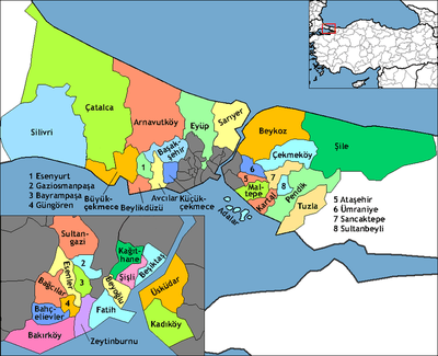
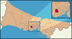
Bağcılar
Bağcılar is a working class suburban district of Istanbul, Turkey. It is located behind Bahçelievler on the European side of the city, between the two major ring roads, the TEM and the E5. The mayor is Lokman Çağırıcı (AKP).
Bağcılar | |
|---|---|
 | |
 Bağcılar | |
| Coordinates: 41°02′26″N 28°49′34″E | |
| Country | Turkey |
| Province | İstanbul |
| Government | |
| • Mayor | Lokman Çağırıcı (AKP) |
| • Kaymakam | İrfan Balkanlıoğlu |
| Area | |
| • District | 21.07 km2 (8.14 sq mi) |
| Population (2012)[2] | |
| • District | 749,024 |
| • District density | 36,000/km2 (92,000/sq mi) |
| Website | www.bagcilar.bel.tr |
Sparsely populated countryside at the time of founding of the Turkish republic, bağcılar means "vine growers" in Turkish and was known as "Yeşilbağ" (Green Vineyard in Turkish). But the district has been urbanized within the last decades. Most of the housing in Bağcılar was illegally built Gecekondu but has now been replaced by rows of cramped apartment buildings, also built with minimal regulation. It is an example of failed urban planning, perhaps exemplified by the fact that Bağcılar was not created as a district in its own right until 1992, by which time the original inhabitants had all left and building in the area was out of control.
The local council is now trying to invest in parks, cafes and other amenities but the area is so full that there is little space.
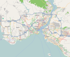
Bağcılar also houses a great deal of industry, particularly light engineering, textiles, printing (Bağcılar is home to all the biggest of Turkey's newspapers and TV channels), a huge wholesale market for dry goods, a large second-hand car market, and many trucking companies, particularly along the Gunesli link road from the TEM motorway to Istanbul airport. A metro is being built which it is hoped will ease the constant stream of slowly circulating traffic.
Public Transportation
Bağcılar is one of the most developed districts in Istanbul in terms of public transportation. It is connected to Yenikapı by M1B subway line. Moreover, T1 tram line starts from Bağcılar to Kabataş. Beside them, the district has several number of bus option as well.
References
- "Area of regions (including lakes), km²". Regional Statistics Database. Turkish Statistical Institute. 2002. Retrieved 2013-03-05.
- "Population of province/district centers and towns/villages by districts - 2012". Address Based Population Registration System (ABPRS) Database. Turkish Statistical Institute. Retrieved 2013-02-27.
- "Historical Background of Bağcılar District" (in Turkish). Governorship of Bağcılar, Istanbul. 2009. Archived from the original on September 6, 2009. Retrieved 2009-08-26.
- "Geographical Information on Bağcılar District" (in Turkish). Governorship of Bağcılar, Istanbul. 2009. Archived from the original on September 6, 2009. Retrieved 2009-08-26.
- "Bağcılar Gezi Rehberi". Türkiye'nin En Güncel Gezi ve Seyahat Sitesi. 2020.
External links
| Wikimedia Commons has media related to Bağcılar. |
- District governor's official website (in Turkish)
- District municipality's official website (in English)