Avcılar, Istanbul
Avcılar is a district of Istanbul, Turkey, out of town on the European side of the city, just to the west of the Küçükçekmece inlet of the Sea of Marmara.
Avcılar | |
|---|---|
district | |
 | |
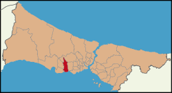 Location of Avcılar in Istanbul | |
 Avcılar Location of Avcılar in Istanbul | |
| Coordinates: 40°58′45″N 28°43′17″E | |
| Country | Turkey |
| City | Istanbul |
| Government | |
| • Mayor | Turan Hançerli (CHP) |
| Area | |
| • District | 39.23 km2 (15.15 sq mi) |
| Population (2012)[2] | |
| • District | 395,274 |
| • District density | 10,000/km2 (26,000/sq mi) |
| Website | www |
History
The Marmara coast road bridges the mouth of the inlet, always an important route in wartime. Therefore, when preparing the conquest of Istanbul the Ottoman forces were keen to populate the Küçükçekmece area with the Turks, the Turkish presence in the area dates from this period.
The road from Istanbul to Europe has become increasingly important ever since and by the time of the population exchange with Greece at the founding of the Turkish Republic there were 50 Greek families in the village, the property they vacated was then used as a military depot. Little is left of this history; the church had long been converted to a mosque and was pulled down in 1977 for a new mosque to be built; fountains and ruins have disappeared. There is some remaining Ottoman architecture including a hunting lodge belonging to the sultans, (the name Avcılar means 'hunters' in Turkish) because actual hunters used to live in this area to protect the villages and some traditional farmhouses.
Avcılar today
Until the second half of the 20th century, Avcılar remained a small village on the coast with lots of open lands. It has grown enormously since the 1980s. .
There has also been a great deal of industrial development, around the port and also on the road out towards the village of Firuzköy, which overlooks the inlet.
At one time the seashore at Avcılar was a retreat from the city, but now the port at Ambarlı is very busy. The road to Europe carries more traffic than ever, it is now a busy highway, littered with billboards and heaving with trucks. Traveling into the city from Avcılar requires winding up onto this highway from Avcılar's network of bridges and narrow underpasses.
Apartments in the center of Avcılar near the sea are expensive . The center of Avcılar has places to sit outside, many restaurants, two cinemas, an active night-life and a busy shopping area with pedestrianized shopping streets with American-style fast-food joints, narrow side-streets of little shops and cafes. Young people wander among people selling goods on the sidewalk.
After the 1999 İzmit earthquake, the demographics of Avcılar changed dramatically. Before the earthquake, the majority of the population was Turkish immigrants from the Balkans, civil servants, university students and the sorts which constituted a relatively low crime rate. However, after the earthquake, most of these people left the district for most of the buildings were of low build quality and very vulnerable to earthquakes. The low estate prices attracted many people from mid and east Anatolia and this new demographic introduced a higher crime rate in Avcılar.
The magazine Bayan Yani is created here and it has had resistance from the authorities. Their offices have been visited by people carrying petrol cans. 150 media workers have been held under arrest in Turkey including the cartoonist Musa Kart who is held in a location near to Avcilar.[3]
Istanbul University
One of Istanbul University's campuses is sited in Avcılar, housing the faculties of engineering, business management, sports and veterinary medicine. The campus is far away from the Anatolian Side of Istanbul and transportation was very complicated and difficult before the introduction of the Metrobus system. There is parkland in the campus and around Lake Küçükçekmece.
Earthquake vulnerability
This district was badly hit during 1999 earthquake. A major fault-line follows the Marmara shore and Avcılar is built on low-lying sandy soil, some of its landfill, right on this shore. This and the fact that the buildings are tall and were very cheaply built make it a particularly vulnerable area. Buildings damaged in 1999 have been repaired but an earthquake centered nearer to Istanbul will damage this area severely and destroy it.
References
- "Area of regions (including lakes), km²". Regional Statistics Database. Turkish Statistical Institute. 2002. Retrieved 2013-03-05.
- "Population of province/district centers and towns/villages by districts - 2012". Address Based Population Registration System (ABPRS) Database. Turkish Statistical Institute. Retrieved 2013-02-27.
- Fueling Turkish feminism with satire and humor, Clement Girardot, 16.04.17, Mashallah News, Retrieved June 2017
- "Information on Avcılar district" (in Turkish). Governorship of Istanbul. 2009. Archived from the original on 2011-07-16. Retrieved 2009-08-16.
External links
| Wikimedia Commons has media related to Avcılar. |
- District governor's official website (in Turkish)
- District municipality's official website (in Turkish)
Avcılar, Istanbul in Istanbul Province of Turkey | |||||||||||||||||||||||||||
|---|---|---|---|---|---|---|---|---|---|---|---|---|---|---|---|---|---|---|---|---|---|---|---|---|---|---|---|
| Districts |
| 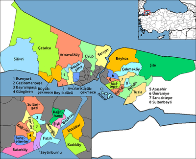 Districts of Istanbul | |||||||||||||||||||||||||
| |||||||||||||||||||||||||||
Metropolitan municipalities are bolded. | |||||||||||||||||||||||||||