Pendik
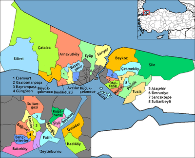
Pendik is a district of Istanbul, Turkey on the Asian side between Kartal and Tuzla, on the Marmara Sea. Population is 711,894. It also neighbours Sultanbeyli, Sancaktepe and Çekmeköy from northwest, Şile from north and Gebze from northeast.
Pendik | |
|---|---|
district | |
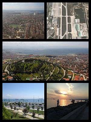 Various views from Pendik. | |
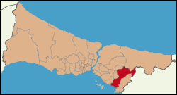 Location of Pendik in Istanbul | |
 Pendik Location of Pendik in Istanbul | |
| Coordinates: 40°52′39″N 29°15′05″E | |
| Country | Turkey |
| City | Istanbul |
| Government | |
| • Mayor | Ahmet Cin (AKP) |
| • Governor | İlhan Ünsal |
| Area | |
| • District | 167.92 km2 (64.83 sq mi) |
| Population (2019)[2] | |
| • District | 711,894 |
| • District density | 4,200/km2 (11,000/sq mi) |
| Time zone | UTC+2 (EET) |
| • Summer (DST) | UTC+3 (EEST) |
| Area code(s) | 0-216 |
| Website | www |
History
There are records of settlements in Pendik going back to 5,000 years ago, a Greek settlement in 753 BC, and many more conquests. In 1080, the town was taken over by the Seljuk Turks, and recaptured by the Byzantines in 1086 and so on. During the Byzantine era, the place was called Pantikion or Pentikion, and before that Pantikap[a]ion in Greek (as the town had five walls, or five gates, or both). Pendik was always a retreat from the city, and by the 20th century was peppered with holiday and weekend homes of Istanbul's wealthy. It was part of Kartal district till 1987. Tuzla one separated from it in 1992. Pendik had present borders with return boroughs of Güzelyalı and Esenyalı (now divided between Güzelyalı, Orhangazi, Esenyalı, Fatih and Ahmet Yesevi ones) from Tuzla in 1994.
Pendik today
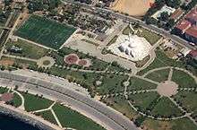
Until the 1970s Pendik was a rural area, far from the city. Today Pendik is a crowded mix of working class housing (especially further towards the E5 motorway) with more expensive apartments with sea views along the coast. There is a busy shopping district (with a large street market on Saturdays), restaurants and movie theaters.
Pendik is far from downtown Istanbul. There used to be suburban trains running from Haydarpasa to Pendik railway station but as part of the Marmaray project this line is currently out of service (it is expected to reopen in 2018). Since 25 July 2014, high-speed services to Ankara start from this station, pending termination of the upgrades on the line to Istanbul proper. In 2016, an extension of the M4 line of the Istanbul Metro was completed. The Pendik metro station is located about 1 kilometre (0.62 mi) north of the railway station.
The coastal road is fast but does not carry public transport, except for the bus 16A which only runs until 8pm and the Kadikoy-Bostanci-Pendik dolmus. There is road construction going on in the Pendik/Tuzla/Gebze region, which has seen industrial development in the 1990s.
Over the centuries, Bosniaks have migrated to Turkey, with a large number arriving after the Austro-Hungarian campaign in Bosnia and Herzegovina in 1878. Many settled in the Pendik boroughs of Sapanbağları, Yeşilbağlar and Bahçelievler. Apart from naming their streets and shops after their village in Bosnia, these people have blended into the Istanbul working-class lifestyle of the rest of Pendik.
In the late 1990s two private educational institutions were built inland from Pendik, Koç Özel Lisesi and Sabancı University. The area has a Formula One racetrack. There is a high-speed boat across the Marmara Sea to Yalova for people travelling out of the city to Bursa and the Aegean. Sabiha Gökçen airport is near.
And currently mayor is Ahmet Cin from AK Parti.
Twin cities
References
- "Area of regions (including lakes), km²". Regional Statistics Database. Turkish Statistical Institute. 2002. Retrieved 5 March 2013.
- "Population of province/district centers and towns/villages by districts - 2012". Address Based Population Registration System (ABPRS) Database. Turkish Statistical Institute. Retrieved 27 February 2013.
External links
| Wikimedia Commons has media related to Pendik. |
- Pendik Municipality website (in Turkish)
- Pendik High School website (in Turkish)
- Pendik Guide
- Pendik News