Sultanbeyli
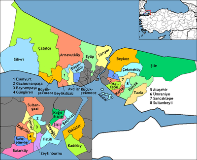
Sultanbeyli (pronounced [sulˈtanbejli]) is a district of Istanbul, Turkey, located inland on the Asian side of the city. It has a population of 298,143 as of 2011, more than triple the 1990 figure of 82,298. The mayor is Hüseyin Keskin of the Justice and Development Party. Sultanbeyli is a landlocked district, bordered by Sancaktepe to the west, Pendik to the east and Kartal to the south-west.
Sultanbeyli | |
|---|---|
district | |
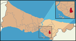 Location of Sultanbeyli in Istanbul | |
 Sultanbeyli Location of Sultanbeyli in Istanbul | |
| Coordinates: 41°11′00″N 28°59′00″E | |
| Country | Turkey |
| City | Istanbul |
| Government | |
| • Mayor | Hüseyin Keskin (AKP) |
| • Governor | Mehmet Ceylan |
| Area | |
| • District | 23.61 km2 (9.12 sq mi) |
| Elevation | 130 m (430 ft) |
| Population (2012)[2] | |
| • District | 302,388 |
| • District density | 13,000/km2 (33,000/sq mi) |
| Time zone | UTC+2 (EET) |
| • Summer (DST) | UTC+3 (EEST) |
| Area code(s) | 0-216 |
| Website | www |
History
Historically the Sultanbeyli area was farmland on the far outskirts of Istanbul, until 1945 when the large land holdings of the Ottoman period were broken up, and 7,500 acres of land around the old Ankara-Istanbul road was parcelized for the settlement of Turkish migrants from Bulgaria. In 1957, Sultanbeyli was formally organised as a village, and after its establishment some shareholders began to sell their plots of land. The handover of the title deed for these sales could not be carried out because the forestry administration put restrictions on Sultanbeyli, but the sales continued.
Sultanbeyli became a large settlement centre in the late 1980s following the connection of the O-4 Motorway to the newly-constructed Fatih Sultan Mehmet Bridge in 1988. The new transport links made the village an attractive location for settlement, and between 1985 and 1990, Sultanbeyli's population skyrocketed from 3741 to 82 298. On December 31, 1987, the decision was made to establish Sultanbeyli as a municipality in the Kartal district of Istanbul, however, the administrative problems caused by the excessive population increase led to the first municipal elections only being held on 26 March 1989, and to the municipality being separated from Kartal into its own district in 1992. This caused Sultanbeyli to develop a reputation as a slum, but has since transitioned into a working class suburb.
References
- "Area of regions (including lakes), km²". Regional Statistics Database. Turkish Statistical Institute. 2002. Retrieved 2013-03-05.
- "Population of province/district centers and towns/villages by districts - 2012". Address Based Population Registration System (ABPRS) Database. Turkish Statistical Institute. Retrieved 2013-02-27.