Ardahan Province
Ardahan Province (Turkish: Ardahan ili; Kurdish: Parêzgeha Erdexanê[2]; Armenian: Արդահան; Georgian: არტაანი), is a province in the north-east of Turkey, at the very end of the country, where Turkey borders with Georgia and Armenia. The provincial capital is the city of Ardahan.
Ardahan Province Ardahan ili | |
|---|---|
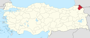 Location of Ardahan Province in Turkey | |
| Country | Turkey |
| Region | Northeast Anatolia |
| Subregion | Ağrı |
| Provincial seat | Ardahan |
| Government | |
| • Electoral district | Ardahan |
| Area | |
| • Total | 5,661 km2 (2,186 sq mi) |
| Population (2018)[1] | |
| • Total | 98,907 |
| • Density | 17/km2 (45/sq mi) |
| Area code(s) | 0478 |
| Vehicle registration | 75 |
History
The first surviving record about this region is attributed to Strabo, who calls it Gogarene (Gugark) and mentions that it was a part of the Armenia, taken away from the Kingdom of Iberia.[3][4] In the Middle Ages Ardahan served as an important transit point for goods arriving from the Abbasid Caliphate and departing to the regions around the Black Sea. During the 8th to 10th centuries the region was in hands of the Bagrationi princes of Tao-Klarjeti, and later part of Kingdom of Georgia between 11th to 15th centuries. It was a theatre of war during the Byzantine-Georgian wars. According to the Arab historian Yahya of Antioch, the Byzantines razed Ardahan and slaughtered its population in 1021.[4] The Mongols took hold of the region in the 1230s but the Georgian princes of Samtskhe were able to recapture it in 1266. As a result of Peace of Amasya, signed in 1555, Ardahan passed to Ottoman hands and reorganized into the Ardahan sanjak as part of eyalet of Childir. In 1578 Ottomans appointed the former Georgian prince, Manuchar (who took the name of Mustafa after converting to Islam) as the first governor.[5] From 1625 onwards the entire eyalet was a hereditary possession of the now-Muslim atabegs of Samtskhe,[6] which administered it as hereditary governors, with some exceptions, until the mid-18th century.[5]
In 1878, after the Russo-Turkish War (1877–1878), the region was incorporated into the Russian Empire, and until 1918 was known as Kars Oblast. Northern part of the province is Democratic Republic of Georgia from 1918 to 1921 and southern part of the province is Democratic Republic of Armenia from 1918 to 1920, Ardahan was reclaimed by Turkey under the Treaty of Kars in 1921.
The construction of the Baku–Tbilisi–Ceyhan pipeline gave the local economy a brief boost from 2000 onwards.
Geography
Ardahan province is located in the far north east of Turkey, where the eastern extremity of the high plateau of Eastern Anatolia converges with the Lesser Caucasus mountain range. It is consequently an area of very high altitude and severe winters. This is attractive open countryside which however spends many months of the year under snow. At this altitude temperatures on average reach −20 °C (−4 °F) and can drop below freezing all year round, including summer months.
The local economy depends on farming and raising livestock. Until 1993 Ardahan was a district of the province of Kars, becoming a province in its own right has meant more investment in infrastructure
There are two crossing points into the Samtskhe–Javakheti district of Georgia, one at Posof and the other (currently closed) at Çıldır. The Turkish military have a strong presence in this border district, another boost to the local economy.
Climate
The predominant climate in the Ardahan province is humid continental climate (Köppen climate classification Dfb) bordering on a subarctic climate (Dfc), with most large settlements in the province being located in lowest possible elevation areas, in attempt to avoid the year-round cold temperatures, thus staying just below the subarctic limit. Smaller locales, districts, villages and a significant portion of the landscape, exhibits a true subarctic climate (Dfc), being the second most widespread climate in the region.[7]
Population
Ardahan is an impoverished area that since the 1950s has seen many of its people migrate to other parts of Turkey or abroad. The population declined from 170,000 people in 1990 to 119,000 in 2000. The population is 105,454 as of 2010. Ethnic groups in the region include, Turks, Georgians and Azerbaijanis. In the period when the province was part of Russian Empire between 1878 and 1917, it was part of the militarily administered Kars Oblast.
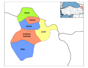
Districts
Ardahan province is divided into 6 districts (capital district in bold):
Cities and towns
Places of interest
- There are a number of medieval castles in the district including Şeytan Castle.
- Lake Çıldır
- Phantom of Atatürk in city of Damal
There is a unique natural incident, between mid of June and mid July during sunset, depending on angles of the sunrays. An image resembling the silhouette of Atatürk's face can be seen as a shadow on the hillside. It was first seen by a shepherd who was with his herd over the hill.[8]
References
- "Population of provinces by years - 2000-2018". Turkish Statistical Institute. Retrieved 9 March 2019.
- "Bakûr di bin berfê de ye! Rêya 1.609 gundan hate girtin" (in Kurdish). Sopger. 18 January 2019. Retrieved 27 April 2020.
- Strabo. Geographica. 11.14.7.
- (in Armenian) «Արդահան» [Ardahan]. Armenian Soviet Encyclopedia. Yerevan: Armenian Academy of Sciences, 1976, vol. ii, p. 7.
- Gábor Ágoston; Bruce Alan Masters (2009-01-01). Encyclopedia of the Ottoman Empire. Infobase Publishing. p. 141. ISBN 978-1-4381-1025-7. Retrieved 2013-06-01.
- D. E. Pitcher (1972). An Historical Geography of the Ottoman Empire: From Earliest Times to the End of the Sixteenth Century. Brill Archive. p. 140. GGKEY:4CFA3RCNXRP. Retrieved 2013-06-01.
- "Climate:Ardahan". Climate-data.org. Retrieved 2016-06-09.
- https://www.ntv.com.tr/galeri/seyahat/ardahanda-ataturk-silueti-gorulmeye-baslandi,jqcEH5dVwU6oPHBYrDReXQ. Missing or empty
|title=(help)
| ||
Metropolitan municipalities are bolded. | ||