Osmaniye Province
Osmaniye Province (Turkish: Osmaniye ili) is a Turkish province located in southern Turkey. It existed as a province by the name Cebel-i Bereket (meaning "Fertile Mountain") in the early republic until 1933, when it was incorporated into Adana Province. It was made a province again in 1996. It covers an area of 3,767 km2 and has a population of 479,221 (2010 est). The province is situated in Çukurova, a geographical, economical and cultural region.
Osmaniye Province Osmaniye ili | |
|---|---|
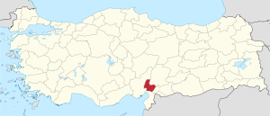 Location of Osmaniye Province in Turkey | |
| Country | Turkey |
| Region | Mediterranean |
| Subregion | Hatay |
| Government | |
| • Electoral district | Osmaniye |
| Area | |
| • Total | 3,767 km2 (1,454 sq mi) |
| Population (2018)[1] | |
| • Total | 534,415 |
| • Density | 140/km2 (370/sq mi) |
| Area code(s) | 0328 |
| Vehicle registration | 80 |
The capital of the province is Osmaniye (Population: 194,000). The next largest towns are Kadirli (Population: 83,618) and Düziçi (Population: 42,000).
Districts
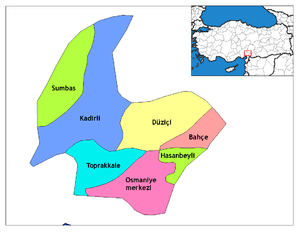
Osmaniye districts
Osmaniye province is divided into 7 districts (capital district in bold):
Historical sites and ruins
Notable people
- Yaşar Kemal, one of the best known writers in Turkey
- Devlet Bahçeli
- Samet Aybaba
- Ahmet Yildirim
Festivals
- Karakucak Wrestling Festival - Kadirli (25–26 May)
Gallery
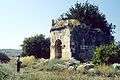 Ancient city of Hierapolis Castabala in Osmaniye
 A view from the city of Osmaniye
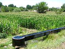 Corn field and irrigation canal
See also
References
- "Population of provinces by years - 2000-2018". Turkish Statistical Institute. Retrieved 9 March 2019.
- Ancient mosaics discovered in southern Turkey
External links
| Wikimedia Commons has media related to Osmaniye Province. |
- (in Turkish) Osmaniye governor's official website
- (in Turkish) Osmaniye municipality's official website
- (in Turkish) Osmaniye Haber
- (in English) Osmaniye weather forecast information
| ||
Metropolitan municipalities are bolded. | ||
This article is issued from Wikipedia. The text is licensed under Creative Commons - Attribution - Sharealike. Additional terms may apply for the media files.