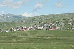
Damal
Damal, formerly Petereke, is a town and district of Ardahan Province of Turkey, on the road from Kars to Posof.
Damal | |
|---|---|
 | |
 Damal | |
| Coordinates: 41°20′30″N 42°50′30″E | |
| Country | Turkey |
| Province | Ardahan |
| Government | |
| • Mayor | Ergin Önal (CHP) |
| • Kaymakam | Mehmet Nuri Çetin |
| Area | |
| • District | 328.83 km2 (126.96 sq mi) |
| Population (2012)[2] | |
| • Urban | 3,416 |
| • District | 6,245 |
| • District density | 19/km2 (49/sq mi) |
| Post code | 75600 |
| Website | www.damal.bel.tr |
History
Damal is on a route across the traditional Silk Road, connecting the Caucasus from Europe to Central Asia and has changed hands many times throughout history, between Armenians, Medes, Persians, Ancient Romans, Georgians, Byzantines and finally the Ottoman Turks. The region was briefly controlled by Imperial Russia but later restored to Turkey after World War One.
Geography
This is a rural area in high mountain, a collection of villages rather than a district built around a central town, watered by mountain springs, the district was created in order to bring more public buildings and government jobs and thus stem the drift of people away from the area. This part of a Turkey has a cold, hard climate, temperatures drop to -38°C(36,4°F) in winter.
The rag dolls of Damal are renowned and have won prizes in craftwork festivals.
References
- "Area of regions (including lakes), km²". Regional Statistics Database. Turkish Statistical Institute. 2002. Retrieved 2013-03-05.
- "Population of province/district centers and towns/villages by districts - 2012". Address Based Population Registration System (ABPRS) Database. Turkish Statistical Institute. Retrieved 2013-02-27.
Damal in Ardahan Province of Turkey | |||||||||||||||||||||||||||
|---|---|---|---|---|---|---|---|---|---|---|---|---|---|---|---|---|---|---|---|---|---|---|---|---|---|---|---|
| Districts | 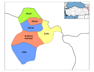 Districts of Ardahan | ||||||||||||||||||||||||||
| |||||||||||||||||||||||||||
Metropolitan municipalities are bolded. | |||||||||||||||||||||||||||