Hans Island
Hans Island (Greenlandic: Tartupaluk; Inuktitut: ᑕᕐᑐᐸᓗᒃ; French: Île Hans pronounced [il ɑ̃]; Danish: Hans Ø) is a barren uninhabited island measuring 1.3 km2 (0.5 sq mi), 1,290 m (4,230 ft) long and 1,199 m (3,934 ft) wide, in the centre of the Kennedy Channel of Nares Strait—the strait that separates Ellesmere Island from northern Greenland and connects Baffin Bay with the Lincoln Sea. Hans Island is the smallest of three islands in Kennedy Channel off the Washington Land coast; the others are Franklin Island and Crozier Island. The strait at this point is 35 kilometres (22 mi) wide, placing the island within the territorial waters of both Canada and Greenland. A theoretical line in the middle of the strait goes through the island.
| Disputed island Native name: Tartupaluk, ᑕᕐᑐᐸᓗᒃ Other names: Hans Ø, Île Hans | |
|---|---|
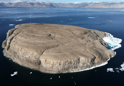 Hans Island from the east (Greenland) side | |
| Geography | |
 Location of Hans Island, between Greenland and Ellesmere Island | |
| Location | Kennedy Channel of the Nares Strait |
| Coordinates | 80°49′41″N 66°27′35″W |
| Area | 1.3 km2 (0.5 sq mi) |
| Length | 1,290 m (0.8 mi) |
| Width | 1,199 m (0.745 mi) |
| Administered by | |
| Disputed | |
| Claimed by | |
| Canada | |
| Denmark | |
| Demographics | |
| Population | Uninhabited |
.png)
The island has likely been part of Inuit hunting grounds since the 14th century.[1] It is claimed by Denmark on behalf of Greenland's home rule government and also by Canada.[2] In accordance with the Greenland home rule treaty, Denmark handles certain foreign affairs, such as border disputes, on behalf of the entire Danish Realm. The nearest populated places are Alert, Canada (198 km or 123-mile distance, pop. 62), Siorapaluk, Greenland (349 km or 217-mile distance, pop. 68) and Qaanaaq, Greenland (379 km or 235-mile distance, pop. 656).
Name
The island is named after Hans Hendrik, whose native Greenlandic name was Suersaq. Hendrik was an Arctic traveller and translator who worked on the American and British Arctic expeditions of Elisha Kent Kane, Charles Francis Hall, Isaac Israel Hayes and George Strong Nares, from 1853 to 1876.
Prior to 2005, the island was thought to have been named during Charles Francis Hall's third North Pole expedition between 1871 and 1873. The first written reference to the name and the island itself appears in Charles Henry Davis's book Narrative of the North Polar expedition (1876), which is a narrative of Hall's third North Pole expedition. On page 407 it appears, without any previous mention. The island made its first cartographic appearance on a map accompanying the book.
Charles Henry Davis writes,
The ship was tied to a large floe, and drifted slowly down the channel with the pack; about noon, she was quite near Hans Island and west of it. The latitude by observation was 80° 48′ N; longitude 68° 38′ W. The ship continued to drift, and at 7 p.m. was midway between Hans and Franklin Island, which are ten miles[note 1] distant from each other. Soundings were taken at a depth of 203 fathoms,[note 2] with a bottom of black limestone.
He was referring to the ship Polaris's return voyage southward down the Kennedy channel. This does not answer when it was named. However, the ship's doctor and leader of the scientific part of the expedition, Emil Bessels, wrote of it in his own book, Die amerikanische Nordpol-Expedition (1879). On page 124 he tells that on August 29, 1871, on the voyage north through Kennedy Channel, the Polaris sailed between Grinnell-land (Ellesmere Island) and a small unknown island which they later named Hans Island, after his native Greenlandic helper, Hans Hendrik.
An earlier mention of a Hans Island expedition is in Elisha Kent Kane's Arctic Explorations: The Second Grinnell Expedition, 1853, ’54, ’55, (published 1857), in pages 317–319. Thus the year 1853 is now often cited as the date of the discovery and naming of the island, including in a letter by the Danish Ambassador to Canada in the Ottawa Citizen on July 28, 2005.
We now neared the Littleton Island of Captain Inglefield where a piece of good fortune awaited us. We saw a number of ducks, both eiders and hareldas; and it occurred to me that by tracking their flight we should reach their breeding-grounds. There was no trouble in doing so, for they flew in a bee-line to a group of rocky islets, [..snip..] A rugged little ledge, which I named Eider Island, was so thickly colonized that we could hardly walk without treading on a nest [..snip..] Nearby was a low and isolated rock-ledge, which we called Hans Island. The glaucous gulls, those cormorants of the Arctic seas, had made it their peculiar homestead.
Littleton Island (Greenlandic: Pikiuleq) is approximately 1 km (0.6 mi) from Greenland's coast right in Smith Sound. It is about 300 km (190 mi) south of the island today called Hans Island. Around it and the coast of Greenland lay dozensof tiny Islands, and Kane names one of them Hans Island after Hans Hendrik, the native Greenlandic helper he had with him on the trip. That this is the current Littleton Island is confirmed by Kane mentioning Edward Augustus Inglefield, who named Littleton Island.
The names of many places in this region have changed or been altered during the last 100 years. For example, the name of Nares Strait (named after George Strong Nares), separating Ellesmere Island and Northern Greenland, was not agreed upon between the Danish and Canadian governments until 1964.
History and disputed sovereignty
Early history
Inuit living in northern Greenland or Canada would have known the island for centuries. In the mid 19th century, Nares Strait was likely unknown to Europeans.[3] It is not known whether Vikings visited the island in the centuries when Greenland was inhabited by Norsemen.
From 1850 to 1880, the area in which Hans Island is situated was explored by American and British expeditions. These expeditions were a response partly due to the popular search for the missing British explorer John Franklin, and partly to search for the elusive Northwest Passage and/or reach the North Pole.
The Danish "Celebration Expedition" of 1920 to 1923 accurately mapped the whole region of the Northern Greenland coast from Cape York (Kap York) to Denmark Sound (Danmark fjord).
In 1933, the Permanent Court of International Justice declared the legal status of Greenland in favour of Denmark. Denmark claims geological evidence points to Hans Island being part of Greenland, and therefore it belongs to Denmark by extension of the Court's ruling.[4]
Since the 1960s, numerous surveys have been undertaken in the Nares Strait region, including seismic, ice flow, mapping, archeological and economic surveys. Canadian-based Dome Petroleum Ltd. made surveys on and around Hans Island from 1980 to 1983, to investigate the movement of ice masses.
1972–73 border treaty
In 1972, a team consisting of personnel from the Canadian Hydrographic Service and Danish personnel working in the Nares Strait determined the geographic coordinates for Hans Island. During negotiations between Canada and Denmark on their maritime boundary in 1973, both states claimed Hans Island was part of their territory. No agreement was reached between the two governments on the issue.
The maritime boundary immediately north and south of Hans Island was established in the continental shelf treaty ratified by Greenland and Canada and then submitted to the United Nations on December 17, 1973, in force since March 13, 1974.[5] At the time, it was the longest shelf boundary treaty ever negotiated and may have been the first ever continental shelf boundary developed by a computer.
The Government of the Kingdom of Denmark and the Government of Canada, having decided to establish in the area between Greenland and the Canadian Arctic Islands a dividing line beyond which neither Party exercising its rights under the Convention on the Continental Shelf of April/29/1958 will extend its sovereign rights for the purpose of exploration and exploitation of the natural resources of the continental shelf…
The treaty lists 127 points (latitude and longitude) from the Davis Strait to the end of the Robeson Channel, where the Nares Strait runs into the Lincoln Sea, to draw geodesic lines between, to form the border. The treaty does not, however, draw a line from point 122 (80°49′12"N, 66°29′00"W) to point 123 (80°49′48"N, 66°26′18"W), a distance of 1,370 m (4,490 ft), because Hans Island is situated in between those two points.[6]
Joint administration
In 1984 Kenn Harper, a historian from Iqaluit, wrote an article about Hans Island which was published in the local newspaper Nunatsiaq News in Qaanaaq (Thule) in northwestern Greenland. This article was picked up by a Danish newspaper in Copenhagen, and by CBC Radio in Canada.[7]
This article was sparked because of a chance encounter on the ice near Resolute, in the Canadian Arctic in the autumn of 1983. According to Harper, he met a man wearing a hat with bold letters around the side of the hat saying "HANS ISLAND, N.W.T." This man was a scientist with Dome Petroleum who had just spent the summer on the island doing ice research. Dome Petroleum did research on and around the island from 1980 to 1983.[8]
Simultaneously, the Danish and Canadian governments were in the process of signing a cooperation agreement in relation to the marine environment in the Nares Strait. The agreement was signed and put into force on August 26, 1983.[9] The Agreement addresses protection of the marine environment of the waters lying between Canada and Greenland, particularly with respect to preparedness measures as a contingency against pollution incidents resulting from offshore hydrocarbon exploration or exploitation and from shipping activities that may affect the marine environment.
One of the items also discussed was the possibility of establishing a reciprocal arrangement for processing applications to conduct research on and around Hans Island. This was never signed; however, Canadian John Munro, at the time Minister for Northern Affairs and Development, and Dane Tom Høyem, at the time Minister for Greenland, agreed, in common interest, to avoid acts that might prejudice future negotiations.
However, unknown to the politicians, Dome Petroleum was doing research on the island.[10]
In 1984, the Danish Minister for Greenland planted the Danish flag on the Island and left a little message saying "Velkommen til den danske ø" (English: Welcome to the Danish Island).[11] It is also said he left a bottle of brandy,[11] however this seems to have been Schnapps,[12] which unlike brandy is a traditional Danish spirit. The Canadians have reciprocated with their own sign, the flag of Canada and a bottle of Canadian Club.[13]
Media attention and continuing negotiations
Though CBC and others had done some reporting in the 1980s,[14] the dispute came to popular attention through Canadian press stories during late March 2004. Within days, it spread to other newspapers worldwide.
On March 25, 2004, when Adrian Humphreys of the Canadian National Post newspaper wrote an article entitled "Five-year plan to 'put footprints in the snow' and assert northern sovereignty", Humphreys made a brief mention of the dispute over Hans Island, and that the Danes had sent warships to the island.
The Arctic sea region has long been a subject of the dispute. In this matter, Canada, Denmark, Iceland, Russia, and Norway share a common interest because they regard parts of the Arctic seas as "national waters". The United States and most European Union countries, on the other hand, officially regard the region as international waters. Further items in the Canadian media led to the issue being picked up by international news organizations.
The Government of Canada's 2004 budget was introduced on March 23, 2004, two days before the issue gained widespread attention. It proposed minimal increases to spending on national defence. The issue of Hans Island was raised in the Canadian Parliament by opposition foreign affairs critic Stockwell Day to highlight the government's failure to provide more funding for the military.
A new article by Adrian Humphreys on March 30, 2004, also in the National Post, entitled "Danes summon envoy over Arctic fight—the solution of the dispute is not going to be military", drew even more attention to the issue. The article claimed Brian Herman, Canada's only diplomat in Denmark (ambassador Alfonso Gagliano having been recently recalled as a result of an unrelated Canadian scandal), was called before the Danish Ministry of Foreign Affairs, to comment about his country's intentions in the dispute, which had, according to the article, recently been inflamed by Danish sailors occupying Hans Island.
On March 31, 2004, the Danish and Canadian governments denied Herman or any other Canadian official was summoned to the Danish Ministry of Foreign Affairs. Both governments stated the dispute was a long-standing issue, and nothing had changed in the matter.
A Canadian military exercise, named "Narwhal 04", inflamed the issue further. However, this exercise had been in the planning stage since September 2003, and it took place around Pangnirtung, Baffin Island, 2,000 km (1,240 mi) south of Hans Island. The Canadian military denied the exercise had anything to do with the Danish–Canadian territorial dispute. The exercise took place from August 9 to 30, 2004, involving about 160 soldiers from the army, various aircraft, helicopters and one frigate, HMCS Montréal. About 600 Canadian Forces personnel were involved in total.
A new development came to light after Canadian Defence Minister Bill Graham visited the island on July 20, 2005. Peter Taksø-Jensen, the head of the International Law department at Denmark's foreign ministry, said the following in an interview with Reuters on July 25 in response to the event:
We consider Hans Island to be part of Danish territory and will therefore hand over a complaint about the Canadian minister's unannounced visit.[15]
— Peter Taksø-Jensen, Danish Foreign Office
On August 18, 2005, Canadian frigate HMCS Fredericton left Halifax for an Arctic cruise.[16] Canadian officials said the month-long patrol was unrelated to the Hans Island dispute. The Kingston-class coastal defence vessels HMCS Glace Bay and HMCS Shawinigan were also scheduled to patrol the Arctic in 2005.[17]
In July 2007, owing to updated satellite imagery, Canadian authorities realized the line constructed as a basis for the maritime boundary (but not for land) would have run roughly across the middle of the island, but the boundary did not "move" as that required a bilateral agreement by the two states for which negotiations continued.[18]
The two countries maintain a sense of humour in the dispute. Peter Taksøe-Jensen has stated "when Danish military go there, they leave a bottle of Schnapps. And when Canadian military forces come there, they leave a bottle of Canadian Club and a sign saying, 'Welcome to Canada.'"[19]
Negotiations in 2012 between Canada and Denmark, not yet finalized, call for either a condominium or splitting the disputed island's sovereignty in half.[14][20] If the island were to be split by a boundary, it would create a second land neighbour for Canada and Denmark, each of which currently only has one, with the United States and Germany respectively.
On May 23, 2018, Canada and Denmark announced the creation of a Joint Task Force to determine the boundary between Canada and Greenland, including the fate of Hans Island.[21]
Google fight
"Google fight" or "Google war" is the name given to a number of advertisements on the Internet search engine Google which promoted either Danish or Canadian sovereignty over Hans Island.
According to an article in the Ottawa Citizen on July 27, 2005, Toronto resident Rick Broadhead saw an advertisement on Google stating "Hans Island is Greenland. Greenland natives have used the island for centuries" and which linked to a Danish foreign affairs webpage that stated the Danish Ministry of Foreign Affairs had sent a note to Canada's ambassador to Denmark on July 25, 2005 expressing Denmark's regret "the Canadian Minister of National Defence had paid a visit to Hans Island without prior notification of the Danish Government".[22] Poul Erik Dam Kristensen, Denmark's ambassador to Canada, told the press the paid advertisement was not a Danish government initiative and whoever placed it was acting alone.
According to the article, this prompted Broadhead to put up his own advertisement on Google which linked to his own site,[23][24] which promoted the Canadian claim to the island, on July 26.
Timeline
- 1980–1983 – Canadian firm Dome Petroleum did research on and around the island.[25][4]
- 1984 – Tom Høyem, Danish Minister for Greenland, chartered a helicopter to the island.
- 1988 – The Danish Arctic Ocean patrol cutter HDMS Tulugaq (Y388) arrived at the island, built a cairn and placed a flagpole and Danish flag on the island.
- 1995 – The Danish liaison officer and geodesists Geodesy flew in and placed another flagpole and flag.
- Late August 1997 – The Danish Arctic/Ocean patrol cutter HDMS Agpa (Y387) tried to reach the island, but was forced to turn around 241 km (150 mi) from the Island, owing to extreme ice.
- 2001 – Keith Dewing and Chris Harrison, geologists with the Geological Survey of Canada who were mapping northern Ellesmere Island, flew by helicopter to the island.[26]
- August 13, 2002 – The Danish inspection ship HDMS Vædderen (F359) arrived and erected a new cairn, flagpole and flag, finding the 1988 flag missing and the 1995 flag in pieces.
- August 1, 2003 – The crew of the Danish frigate HDMS Triton (F358) landed on the island and replaced the Danish flag again.
- July 13, 2005 – Canadian soldiers land on the Island, placing a traditional Inuit stone marker (Inukshuk) with a plaque and a Canadian flag.
- July 20, 2005 – As a symbolic move, Canadian Defence Minister Bill Graham set foot on the island.[27]
- July 25, 2005 – A Danish government official announced Denmark would issue a letter of protest to Canada.
- July 25, 2005 – Deputy premier of Greenland, Josef Motzfeldt, stated the island had been occupied by Canada, stating experts should determine which country the island belongs to.[28]
- July 28, 2005 – The Danish Ambassador to Canada published an article in the Ottawa Citizen newspaper regarding the Danish view on the Hans Island issue.[29]
- August 4, 2005 – The Danish Arctic/Ocean patrol cutter HDMS Tulugaq (Y388) was sent from Naval Station Grønnedal to Hans Island to assert Danish sovereignty. The cutter was expected to arrive in three weeks' time.[30]
- August 8, 2005 – Danish newspapers reported Canada wished to open negotiations regarding the future of Hans Island. The news was welcomed by Danish Prime Minister Anders Fogh Rasmussen who stated "It is time to stop the flag war. It has no place in a modern, international world. Countries like Denmark and Canada must be able to find a peaceful solution in a case such as this."[31]
- August 16, 2005 – According to Danish Foreign Minister Per Stig Møller, Denmark and Canada agreed to reopen negotiations regarding the future of Hans Island. Denmark would immediately begin geological surveys in the area, and Per Stig Møller would meet his Canadian counterpart Pierre Pettigrew in New York City in the middle of September. Should they fail to reach an agreement, both governments have agreed to submit the dispute to the International Court of Justice in The Hague. The government of Greenland agreed to this course of action. Regarding the Danish patrol cutter HDMS Tulugaq (Y388) then en route to Hans Island, the minister stated "I have instructed the ship to sail there, but they will not go ashore tearing down [the Canadian] flag and replacing it with a new one. It would be a somewhat childish [behaviour] between two NATO allies."[32]
- August 20, 2005 – Canada's Foreign Affairs Minister, Pierre Pettigrew, stated Canada's claim to the island had a firm basis in international law and would likely not end up before a world court. "Our sovereignty over the island has a very strong foundation," the minister said in a telephone interview with a Canadian Press journalist.[17]
- September 19, 2005 – According to Canada's Foreign Affairs Minister, Pierre Pettigrew, Canada and Denmark have agreed on a process to resolve the dispute over the island. Pettigrew and his Danish counterpart, Per Stig Møller, met in New York on this day. Pettigrew said the two countries would work together "to put this issue behind us." However Pettigrew reiterated Canada has sovereignty over the island.[33]
- August 16, 2006 – A Vancouver geologist receives a prospecting permit for Hans Island from the Canadian government.[34]
- March 17, 2007 – Scientists from the University of Toronto and the Technical University of Denmark announced plans to install an automated weather station on the island, some time in the summer of 2007.[35]
- July, 2007 – Canada updates satellite photos and recognizes its line constructed for the earlier maritime agreement would have run roughly through the middle of the island; negotiations continue with Denmark over establishing an international land boundary or island sovereignty.[18]
- May 4, 2008 – An international group of scientists from Australia, Canada, Denmark, and the UK installed an automated weather station on Hans Island.[36]
- April 11, 2012 – Proposal for Canada and Denmark to split Hans Island.[14]
- November 29, 2012 – Canada and Denmark settle an agreement on the exact border between them, though without defining the border near Hans Island.[37]
- May 23, 2018 - Canada and Denmark announce a Joint Task Force to settle the dispute over Hans Island.[21]
- February 2019 - Canadian geologist John Robins is granted a minerals exploration claim for Hans Island by the Canadian government as part of efforts to help the cause of Canada's sovereignty claim.[38]
- September 12, 2019 - The Government of Greenland decided to approve a temporary closure of Hans Island for the application for mineral exploration permits. This approval was based on an agreement between the Government of Canada and the Kingdom of Denmark. The Canadian geologist John Robins therefore also had his minerals exploration claim for Hans Island suspended by the Canadian government. [39]
See also
References
Notes
Citations
- "Whose Hans?". Canadian Geographic. Archived from the original on January 5, 2013.
- McKernan, Bethan (November 13, 2015). "Canada and Denmark are locked in an adorable war". i100.co.uk. Retrieved November 14, 2015.
- Stevenson, Christopher (2007). "Hans Off!: The Struggle for Hans Island and the Potential Ramifications for International Border Dispute Resolution". Boston College International and Comparative Law Review. p. 265.
By most accounts, the first western explorer to discover and name Hans Island was American Charles Francis Hall.
- Andrew T.H. Tan (ed.). The Politics of Maritime Power: A Survey. Routledge Taylor & Francis Group. p. 186. Retrieved February 23, 2019.
- "Agreement between the Government of the Kingdom of Denmark and the Government of Canada relating to the Delimitation of the Continental Shelf between Greenland and Canada (17 December 1973)" (PDF). Delimitation Treaties Infobase. United Nations. March 13, 2002. Retrieved February 20, 2017.
- "Limits in the Seas No. 72 - Continental Shelf Boundary - Canada--Greenland" (PDF). U.S. Department of State. August 4, 1976. Retrieved February 20, 2017.
- Bell, Jim (August 8, 2018). "Paul Quassa's fall was self-inflicted". Nunatsiaq News. Retrieved September 6, 2019.
- Kristiansen, Ryan (August 13, 2002). "Desolate Dispute: A Study of a Hypothetical International Court of Justice (ICI) Decision". Canadian Military Journal Vol. 13, No. 3. Retrieved September 5, 2019.
- ""Agreement between the Government of the Kingdom of Denmark and the Government of Canada for Cooperation Relating to the Marine Environment", 1983-08-26, United Nations, New York.
- ""Hans off Our Island!"". The Copenhagen Post. October 10, 2014. Retrieved September 6, 2019.
- Canada, Denmark agree to resolve dispute over Arctic island, CBC News September 19, 2005 Archived January 27, 2007, at the Wayback Machine
- "Canada and Denmark Fight Over Island With Whisky and Schnapps". The New York Times. November 8, 2016. Retrieved September 6, 2019.
- "Canada and Denmark Whiskey War Over Hans Island". Business Insider. January 8, 2016. Retrieved January 8, 2016.
- "April 11, 2012 audio report on Hans Island". Canadian Broadcasting Corporation. Retrieved April 24, 2012.
- "Europe | Canada island visit angers Danes". BBC News. July 25, 2005. Retrieved November 20, 2009.
- "HMCS Fredericton leaves Halifax for Arctic patrol". CTV.ca. August 18, 2005. Archived from the original on September 25, 2005. Retrieved November 20, 2009.
- "Canada has claim to Hans Island: Pettigrew". CTV.ca. August 20, 2005. Archived from the original on December 6, 2005. Retrieved November 20, 2009.
- The Canadian Press (July 26, 2007). "Satellite imagery moves Hans Island boundary: report". Cbc.ca. Retrieved November 20, 2009.
- Byers, Michael (2009). Who owns the Arctic? : understanding sovereignty disputes in the North (1st U.S. ed.). Vancouver: Douglas & McIntyre. pp. 26–27. ISBN 9781553654995.
- Weber, Bob (November 15, 2015). "Canada, Denmark should turn Hans Island into a condominium: academics". CBC News.
- "Canada and the Kingdom of Denmark (with Greenland) announce the establishment of a Joint Task Force on Boundary Issues" (Press release). Ottawa: Government of Canada. Global Affairs Canada. May 23, 2018. Retrieved May 23, 2018.
- "HANS ISLAND: DANISH NOTE TO CANADIAN AMBASSADOR". Ministry of Foreign Affairs of Denmark. Archived from the original on July 30, 2005. Retrieved August 11, 2010.
- "Island squabble goes Google". Reuters. cnn.com. Archived from the original on July 31, 2005. Retrieved November 6, 2010.
- "Hans Island Belongs to Canada". Rickbroadhead.com. July 26, 2005. Archived from the original on November 22, 2009. Retrieved November 20, 2009.
- Andrew H. Malcolm (February 11, 1979). "Dome Petroleum Is Gambling on an Ice-Bound Bonanza". New York Times. Retrieved February 23, 2019.
- Jane George (April 9, 2004). "Greenland, Canada squabbling over pet rock". Nunatsiaq News. Retrieved February 23, 2019.
- "Hans Island". The Canadian Encyclopedia. Retrieved November 14, 2015.
- Lynge, Mads (July 25, 2005). "Josef Motzfeldt: Uforskammet af Canada" (in Danish). Kalaallit Nunaata Radioa. Retrieved January 12, 2016.
- "Article about the Hans Island issue – Embassy of Denmark Canada". Ambottawa.um.dk. Archived from the original on June 22, 2008. Retrieved November 20, 2009.
- "?".
- "?". Archived from the original on September 18, 2005.
- "Ø-farcen er slut".
- Canada, Denmark agree to resolve dispute over Arctic island Archived December 29, 2010, at the Wayback Machine
- "Geologist to prospect on disputed Hans Island in Arctic". Cbc.ca. August 16, 2006. Retrieved November 20, 2009.
- "Canadian, Danish scientists join Hans". globeandmail.com. March 15, 2007. Archived from the original on March 19, 2007. Retrieved November 20, 2009.
- "Arctic Weather Station". Archived from the original on December 21, 2014.
- "Canada, Denmark closer to settling border dispute". The Globe and Mail. November 29, 2012. Retrieved November 2, 2013.
- Canadian miner files exploratory claim on disputed Arctic island of Hans Retrieved April 6, 2019
- Indstilling til Naalakkersuisut om midlertidig lukning af Tartupaluk (Hans Ø) for ansøgning om mineraltilladelser. Retrieved September 12, 2019
Sources
- United Nations: Delimitation Treaties. Agreement between the Government of the Kingdom of Denmark and the Government of Canada relating to the Delimitation of the Continental Shelf between Greenland and Canada, December 17, 1973,
- U.S. Department of State: Bureau of Intelligence and Research Limits in the Seas No. 72 Continental shelf Boundary: Canada – Greenland, Issued by the Geographer, August 4, 1976.
- Hans Island rightfully belongs to Greenland, Denmark – Kenn Harper, Article, Nunatsiaq News, April 9, 2004.
- Agreement between the Government of Canada and the Kingdom of Denmark for Cooperation relating to the Marine Environment, August 26, 1983.
- Narrative of the North Polar expedition : U.S Ship Polaris, Captain Charles Francis Hall commanding, edited under the direction of G. M. Robeson by C. H. Davis. Washington, G. P. O., 1876.
External links
![]()
- Hans Island in the Atlas of Canada – Toporama; Natural Resources Canada
- Hans Island: A border dispute between Denmark and Canada – Background, maps, timeline about the Hans Island dispute.
- NPR's Morning Edition, Friday, Aug 12, 2005 – Summary of the dispute.
- Newsletter No.3 HDMS Triton – about the August 1, 2003 landing on the island.
- CASR – article on the dispute by the Canadian American Strategic Review.
- Caryophyllaceae of the Canadian Arctic Archipelago
- Canadian Archipelago Throughflow Study
- Crisis in the Arctic!
- Canadian perspective, March 29, 2004 (updated)
- "More Hans Island discussions planned". The Globe and Mail. Copenhagen. August 16, 2005. Archived from the original on April 6, 2019. Retrieved April 5, 2019.