Cornwallis Island (Nunavut)
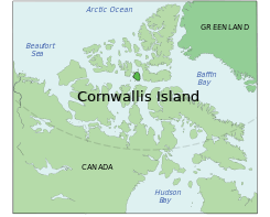
Cornwallis Island is one of the Queen Elizabeth Islands, part of the Arctic Archipelago, in the Qikiqtaaluk Region of Nunavut in the Canadian Arctic. It lies to the west of Devon Island and at its greatest length is about 113 km (70 mi). At 6,995 km2 (2,701 sq mi) in size, it is the 96th largest island in the world, and Canada's 21st largest island. Cornwallis Island is separated by the Wellington Channel from Devon Island, and by the Parry Channel from Somerset Island to the south. Northwest of Cornwallis Island lies Little Cornwallis Island, the biggest of a group of small islands at the north end of McDougall Sound, which separates Cornwallis Island from nearby Bathurst Island.
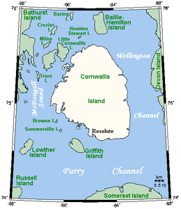 Closeup of Cornwallis Island | |
 | |
| Geography | |
|---|---|
| Location | Northern Canada |
| Coordinates | 75°08′N 95°00′W |
| Archipelago | Queen Elizabeth Islands Canadian Arctic Archipelago |
| Area | 6,995 km2 (2,701 sq mi) |
| Length | 113 km (70.2 mi) |
| Width | 95 km (59 mi) |
| Highest elevation | 359 m (1,178 ft) |
| Highest point | Unnamed High Point |
| Administration | |
Canada | |
| Territory | Nunavut |
| Largest settlement | Resolute (pop. 198) |
| Demographics | |
| Population | 198[1] (2016) |
| Pop. density | 0.03/km2 (0.08/sq mi) |
Cape Airy is located at the island's southwestern extremity.[2] Also on the southwestern coast, Griffith Island lies directly across from the island's only hamlet Resolute (Qausuittuq), separated by the 6.5 mi (10.5 km) wide Resolute Passage.[3] The airport at Resolute acts as a communications hub for the central Arctic islands of Nunavut. This is Canada's second most northerly public community and has a population of 198 in 2016.[1]
The first European to visit Cornwallis Island was the British arctic explorer and naval officer Sir William Edward Parry in 1819. The island is named for Royal Navy admiral Sir William Cornwallis.[4]
Cornwallis Island is also home to microbiological colonies known as hypoliths, from their tendency to take hold under ("hypo") stones ("lith").

References
- "Census Profile, 2016 Census". Statistics Canada. Retrieved 2017-03-03.
- "Cape Airy". The Columbia Gazetteer of North America. 2000. Retrieved 2008-04-30.
- Pharand, Donat; Legault, L.H. (1984). The Northwest Passage: Arctic Straits. Martinus Nijhoff Publishers. p. 7. ISBN 90-247-2979-3.
- Parry, William Edward (1821). Journal of a voyage for the discovery of a North-West passage from the Atlantic to the Pacific: performed in the years 1819-20. London: John Murray.
External links