List of National Historic Sites of Canada in Newfoundland and Labrador
This is a list of National Historic Sites (French: Lieux historiques nationaux) in the province of Newfoundland and Labrador. There are 46 National Historic Sites designated in Newfoundland and Labrador, 10 of which are administered by Parks Canada (identified below by the beaver icon ![]()
The Beaumont-Hamel Newfoundland Memorial, a National Historic Site commemorating Dominion of Newfoundland forces killed during World War I, is located in France.
Numerous National Historic Events also occurred across Newfoundland & Labrador, and are identified at places associated with them, using the same style of federal plaque which marks National Historic Sites. Several National Historic Persons are commemorated throughout the province in the same way. The markers do not indicate which designation—a Site, Event, or Person—a subject has been given.
This list uses names designated by the national Historic Sites and Monuments Board, which may differ from other names for these sites.
National Historic Sites
| Site[1] | Date(s) | Designated | Location | Description | Image |
|---|---|---|---|---|---|
| Basilica of St. John the Baptist[4] | 1855 (completed) | 1983 | St. John's 47°34′2″N 52°42′36″W |
Stone cathedral, constructed in the Lombard Romanesque Revival style, which has played an important role in the province's religious, political and social history | 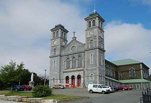 |
| Battle Harbour Historic District[5] | 1770s (established) | 1996 | Battle Harbour 52°16′0″N 55°35′13″W |
A noted example of a traditional outport fishing community; the buildings, structures and open spaces evoke the fishing outports of the 19th and early 20th-century |  |
| Boyd's Cove Beothuk[6] | 3000 BCE (c.) (human occupation) | 1995 | Boyd's Cove 49°27′26″N 54°38′12″W |
A major archaeological site which has substantially increased the knowledge of the early history and demise of the Beothuk people | 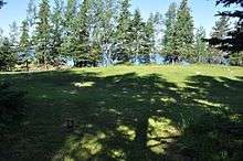 |
| Cable Building[7] | 1913 (completed) | 2008 | Bay Roberts 47°35′47″N 53°15′16″W |
Newfoundland was a major telecommunications hub at the beginning of the 20th century as it offered the shortest link between North America and Europe; the building was the main relay for the transatlantic network of the Western Union Telegraph Company |  |
| Cape Pine Lighthouse[8] | 1851 (completed) | 1974 | Cape Pine 46°37′2″N 53°31′56″W |
First of a series of prefabricated iron lighthouses erected in Newfoundland in the 19th century, for transport to and erection at rugged sites; the first landfall light built on the dangerous south coast of the Avalon Peninsula to guide shipping through the Cabot Strait | 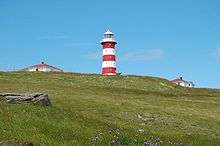 |
| Cape Race Lighthouse[9] | 1907 (completed) | 1975 | Cape Race 46°39′31″N 53°4′25″W |
At the time of this lighthouse's construction, it was the most important light on the dangerous southern shore of the Avalon Peninsula and it housed one of the most powerful lighting apparatuses in the world | 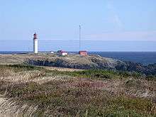 |
| Cape Spear Lighthouse |
1835 (completed) | 1962 | Cape Spear 47°31′20″N 52°37′36″W |
The oldest surviving lighthouse in Newfoundland, constructed on the easternmost point in North America; built in 1835 by the Colony of Newfoundland to signal the approach to St. John's harbour | 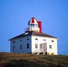 |
| Castle Hill |
1692 (established) | 1968 | Placentia 47°15′3.88″N 53°58′17.31″W |
The remains of French and British fortifications overlooking the town; the defences played an important role in both local defence and the larger military interests of France and Britain in Atlantic Canada | |
| Christ Church / Quidi Vidi Church[12] | 1842 (completed) | 1966 | St. John's 47°34′50″N 52°41′56″W |
A modest, wood church, located on a steep hill overlooking the harbour of the former village of Quidi Vidi; representative of the rapidly disappearing architecture of 19th-century outports | 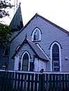 |
| Colony of Avalon[13] | 1621 (established) | 1953 | Ferryland 47°1′22″N 52°52′49″W |
Best preserved early English settlement in Canada | 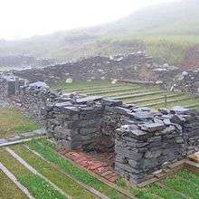 |
| Crow's Nest Officers' Club[14][15] | 1942 (established) | 2011 | St. John's 47°34′4″N 52°42′12″W |
Opened as a seagoing officer's club during the Second World War, the club served men from Allied navies and allowed the men from each vessel to decorate a section of wall as a memento to their ship; the club, along with its military memorabilia and artwork, remains a memorial to the naval war efforts | .jpg) |
| Fleur de Lys Soapstone Quarries[16] | 400 CE (c.) | 1982 | Fleur de Lys 47°1′22″N 52°52′49″W |
Soapstone was an important raw material for many aboriginal societies in Newfoundland, primarily used here for bowls and oil lamps; this archaeological site preserves considerable evidence about resource extraction techniques in Dorset culture | |
| Former Bank of British North America[17] | 1850 (completed) | 1990 | St. John's 47°33′56.76″N 52°42′24.17″W |
A three-and-a-half-storey brick building with mansard roof and Italianate features which housed many of Newfoundland's major banks from 1849 to 1985; closely associated with the evolution of banking in Newfoundland | 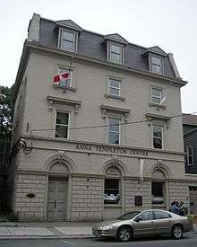 |
| Former Carbonear Railway Station (Newfoundland Railway)[18] | 1918 (completed) | 1988 | Carbonear 47°44′15″N 53°13′47″W |
A one-storey, wood-frame building with a hip roof and overhanging eaves; representative of the stations on the Newfoundland Railway | 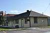 |
| Former Newfoundland Railway Headquarters[19] | 1903 | 1988 | St. John's 47°33′16.21″N 52°42′49.13″W |
A two-and-a-half-storey stone building with both Second Empire and Château design elements; commemorates the important role played by the Newfoundland Railway in the social, economic and political history of the province |  |
| Fort Amherst[20] | 1777 (established) | 1951 | St. John's 47°33′49″N 52°40′50″W |
The site of British fortification built to guard the mouth of St. John's harbour, of which there are no visible remains; named after William Amherst who recaptured St. John's from the French in 1762 |  |
| Fort Townshend | 1773 (established) | 1951 | St. John's 47°33′58″N 52°42′44″W |
An archaeological site at the former location of a British fort that served as the headquarters of the Newfoundland garrison from 1779 until 1871; the site is now occupied by The Rooms |  |
| Fort William[21] | 1697 (established) | 1952 | St. John's 47°34′15″N 52°42′2″W |
The site of a fort which served as the original headquarters of the British garrison in Newfoundland, and which was attacked three times by the French; the fort represented the first official military presence in St. John's, although it was supplanted by Fort Townshend in the 1770s, and demolished in 1881 | |
| Government House[22] | 1831 (completed) | 1982 | St. John's 47°33′49″N 52°40′50″W |
A Palladian-style mansion originally built for Thomas Cochrane, the first civil governor of the Newfoundland Colony; its construction marked the transition of the colony from a naval to civilian government, and the house has served as the official residence of Newfoundland's governors and lieutenant governors ever since | 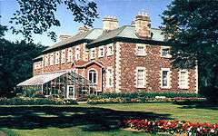 |
| Harbour Grace Court House[23] | 1830 (completed) | 1966 | Harbour Grace 47°41′44″N 53°12′45″W |
A two-storey stone building characterized by a split staircase on the front facade; the oldest surviving public building in the province | 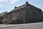 |
| Hawthorne Cottage |
1830 (completed) | 1978 | Brigus 47°32′6.54″N 53°12′35.53″W |
A Picturesque cottage with a wrap-around verandah and a home of Arctic-explorer Robert Bartlett |  |
| Hebron Mission[25] | 1829 (established) | 1976 | Hebron 58°11′58″N 62°37′33″W |
A complex of linked buildings, including a church, mission house, and store, all in a Germanic-influenced architectural style; a Moravian centre of religious instruction to the local Inuit, which also served commercial and medical purposes | 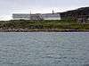 |
| Hopedale Mission |
1782 (established) | 1970 | Hopedale 55°27′30.83″N 60°12′45.21″W |
A complex of large, wooden buildings constructed by the Moravian Church; commemorates the interaction between Labrador Inuit and missionaries, and representative of Moravian Mission architecture in Labrador | 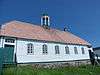 |
| Indian Point[27] | 1978 | Red Indian Lake 48°47′44″N 56°34′38″W |
Well documented Beothuk site | ||
| Kitjigattalik - Ramah Chert Quarries |
3000 BCE to 1400 AD | 2015 | Torngat Mountains National Park 58.976564°N 63.185867°W |
Quarry of unique chert widely traded in eastern America | |
| L'Anse Amour[29] | 6100 BCE (c.) | 1978 | L'Anse Amour 51°28′49″N 56°51′59″W |
One of the largest and longest used Aboriginal habitation sites in Labrador; earliest known funeral monument in the New World | 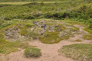 |
| L'Anse aux Meadows |
1000 CE (c.) | 1968 | St. Anthony 51°35′43″N 55°31′59.47″W |
The first known settlement established by Vikings in North America, containing the earliest evidence of Europeans in Canada; a World Heritage Site | 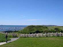 |
| Mallard Cottage[31] | 1820 (c.) (completed) | 1983 | St. John's 47°34′54″N 52°40′42″W |
A wood-frame house with hip roof and central chimney, typical of the vernacular housing built by Irish immigrants in the first half of the 19th century | .jpg) |
| Murray Premises[32] | 1849 (completed) | 1976 | St. John's 47°34′07.67″N 52°42′29.52″W |
A complex of three former warehouses; commemorative of the offices and warehouses which once lined St. John's harbour and of the city's long tradition of sea-based trade | 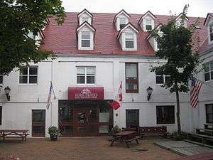 |
| Okak[33] | 5550 BCE (c.) (first human occupation) | 1978 | Okak 51°35′43″N 55°31′59.47″W |
Sixty archaeological sites, dating from 5550 BCE onwards, representative of habitation from Maritime Archaic to Labrador Inuit; location of the second oldest Moravian mission in Labrador, founded in 1776 and abandoned in 1919 | |
| Port au Choix |
1970 | Port au Choix 50°42′14.54″N 57°23′24.01″W |
Two exceptional rare and rich pre-contact archaeological sites, one a Maritime Archaic cemetery and the other a Paleo-Eskimo habitation site |  | |
| Port Union Historic District[35] | 1916 (established) | 1999 | Trinity Bay North 48°29′51″N 53°4′56″W |
The only town in Canada founded by a union; built by the Fishermen's Protective Union along an empty stretch of shoreline, the town was noted for its commercial success in the face of fierce competition from commercial merchants |  |
| Red Bay |
1550 (whaling port established) (c.) | 1979 | Red Bay 51°43′31.34″N 56°25′59.39″W |
A World Heritage Site and the site of one of the largest whaling ports used between 1550 and 1620 by Basque whaling expeditions from France and Spain; well-preserved evidence of the 16th-century whaling activities remain on the site, both on land and submerged in the harbour | 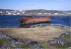 |
| Rennie's Mill Road Historic District[37] | 1846 (established) | 1987 | St. John's 47°34′16″N 52°42′34″W |
Originally a suburb of large, wooden houses mainly from the late 19th to the early 20th centuries; a remarkably homogeneous grouping of upper middle class residences, associated with prominent Newfoundlanders of the period |  |
| Ryan Premises |
1857 (established) | 1987 | Bonavista 48°38′52.31″N 53°6′45.7″W |
A cultural landscape comprising residential and commercial structures typical of a 19th-century Newfoundland mercantile outport, still located in their original setting by the sea | .jpg) |
| St. John the Baptist Anglican Cathedral[39] | 1850 (completed) | 1979 | St. John's 47°33′55″N 52°42′30″W |
A magnificent stone cathedral designed by George Gilbert Scott for Canada's oldest Anglican parish; a nationally significant example of Gothic Revival architecture, and one that conforms to the tenets of the Cambridge Camden Society | 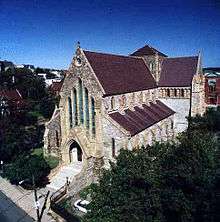 |
| St. John's Court House[40] | 1904 (completed) | 1981 | St. John's 47°33′53″N 52°42′26″W |
A granite and sandstone Romanesque Revival-style courthouse; the most elaborate courthouse in the province and representative of the judicial system in Newfoundland |  |
| St. John's Ecclesiastical District[41] | 2008 | St. John's 47°34′4″N 52°42′41″W |
Buildings and landscape features associated with the Roman Catholic, Anglican, United (formerly Methodist) and Presbyterian denominations; representative of the involvement of Christian institutions in the history and political life of St. John's and the province |  | |
| St. John's WWII Coastal Defences (Atlantic Bulwark)[42] | 1939 (established) | 1993 | St. John's 47°33′49″N 52°40′47″W |
St. John's served as the main North American base for trans-Atlantic escorts during the Second World War; Canadian and American gun batteries and Canadian air force squadrons protected St. John's harbour |  |
| St. Patrick's Roman Catholic Church[43] | 1881 (completed), 1914 (spire) | 1990 | St. John's 47°33′13″N 52°43′1″W |
A noted example of Gothic Revival architecture in Canada; the design reflects the strong links between Ireland and Newfoundland, as well as the influence of Victorian design on colonial churches |  |
| St. Thomas Rectory / Commissariat House and Garden[44] | 1821 (completed) | 1968 | St. John's 47°34′21″N 52°42′9″W |
A wooden building constructed by the Corps of Royal Engineers for the British military garrison; after 1870, it served as the rectory for the Old Garrison Church |  |
| Signal Hill |
1660 (military role established) | 1951 | St. John's 47°34′10.06″N 52°40′56.19″W |
A landmark promontory that frames the entrance to St. John's Harbour, identifiable by the profile of Cabot Tower; site played important roles in Canada's defence and communications histories |  |
| Tilting[46] | 1730 (established) | 2003 | Tilting 49°42′13″N 54°3′38.27″W |
An outport fishing community on Fogo Island; illustrative of the adaptation of Irish settlement patterns to Newfoundland, and a rare surviving example of mid-18th century landscape components | 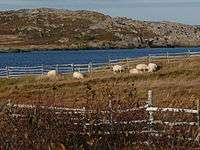 |
| Walled Landscape of Grates Cove[47] | 1790 (established) | 1995 | Grates Cove 48°10′0″N 52°56′22″W |
A 60.7-hectare (150-acre) grassy landscape located on a windswept headland; small fertile gardens, demarcated by stone walls, represent a rare surviving example of a communal system of land and community organization unique to Newfoundland | 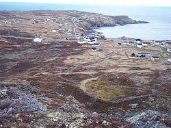 |
| Water Street Historic District[48] | 1847 (commencement of reconstruction after the Great Fire) | 1987 | St. John's 47°33′43.9″N 52°42′34.14″W |
Twenty 19th-century mercantile buildings on Water Street near the harbour; representative of the business establishments associated with the Newfoundland fisheries and the Atlantic trade |  |
| Winterholme[49] | 1907 (completed) | 1991 | St. John's 47°34′20″N 52°42′39″W |
A home originally built for local businessman Marmaduke Winter; a noted example of a conservative approach to the Queen Anne Revival style in Canadian domestic architecture | 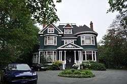 |
See also
| Wikimedia Commons has media related to National Historic Sites of Canada in Newfoundland and Labrador. |
References
- "Newfoundland and Labrador". Directory of Federal Heritage Designations. Parks Canada. Retrieved 17 June 2012.
- Newfoundland and Labrador, National Historic Sites of Canada - administered by Parks Canada
- "1951". Directory of Federal Heritage Designations. Parks Canada. Retrieved 6 August 2012.
- Basilica of St. John the Baptist. Canadian Register of Historic Places. Retrieved 17 June 2012.
- Battle Harbour Historic District. Canadian Register of Historic Places. Retrieved 17 June 2012.
- Boyd's Cove Beothuk. Canadian Register of Historic Places. Retrieved 17 June 2012.
- Cable Building. Canadian Register of Historic Places. Retrieved 1 July 2012.
- Cape Pine Lighthouse. Canadian Register of Historic Places. Retrieved 1 July 2012.
- Cape Race Lighthouse. Canadian Register of Historic Places. Retrieved 1 July 2012.
- Cape Spear Lighthouse. Canadian Register of Historic Places. Retrieved 1 July 2012.
- Castle Hill. Canadian Register of Historic Places. Retrieved 7 July 2012.
- Christ Church / Quidi Vidi Church. Canadian Register of Historic Places. Retrieved 7 July 2012.
- Colony of Avalon. Directory of Federal Heritage Designations. Parks Canada. Retrieved 8 July 2012.
- Crow's Nest Officers' Club. Directory of Federal Heritage Designations. Parks Canada. Retrieved 8 July 2012.
- Crow's Nest Officers' Club. Canadian Register of Historic Places. Retrieved 8 July 2012.
- Fleur de Lys Soapstone Quarries. Directory of Federal Heritage Designations. Parks Canada. Retrieved 8 July 2012.
- Former Bank of British North America. Canadian Register of Historic Places. Retrieved 8 July 2012.
- Former Carbonear Railway Station (Newfoundland Railway). Canadian Register of Historic Places. Retrieved 8 July 2012.
- Former Newfoundland Railway Headquarters. Canadian Register of Historic Places. Retrieved 8 July 2012.
- Fort Amherst. Canadian Register of Historic Places. Retrieved 8 July 2012.
- Fort William. Canadian Register of Historic Places. Retrieved 8 July 2012.
- Government House. Canadian Register of Historic Places. Retrieved 8 July 2012.
- Harbour Grace Court House. Canadian Register of Historic Places. Retrieved 8 July 2012.
- Hawthorne Cottage. Canadian Register of Historic Places. Retrieved 8 July 2012.
- Hebron Mission. Canadian Register of Historic Places. Retrieved 8 July 2012.
- Hopedale Mission. Canadian Register of Historic Places. Retrieved 8 July 2012.
- Indian Point. Directory of Federal Heritage Designations. Parks Canada. Retrieved 8 July 2012.
- Torngat Mountains National Park Experiences 2015, Parks Canada 2015, page 2
- L'Anse Amour. Canadian Register of Historic Places. Retrieved 8 July 2012.
- L'Anse aux Meadows. Canadian Register of Historic Places. Retrieved 8 July 2012.
- Mallard Cottage. Canadian Register of Historic Places. Retrieved 8 July 2012.
- Murray Premises. Canadian Register of Historic Places. Retrieved 8 July 2012.
- Okak. Canadian Register of Historic Places. Retrieved 8 July 2012.
- Port au Choix. Canadian Register of Historic Places. Retrieved 8 July 2012.
- Port Union Historic District. Canadian Register of Historic Places. Retrieved 14 July 2012.
- Red Bay. Canadian Register of Historic Places. Retrieved 14 July 2012.
- Rennie's Mill Road Historic District. Canadian Register of Historic Places. Retrieved 14 July 2012.
- Ryan Premises. Canadian Register of Historic Places. Retrieved 14 July 2012.
- St. John the Baptist Anglican Cathedral. Canadian Register of Historic Places. Retrieved 14 July 2012.
- St. John's Court House. Canadian Register of Historic Places. Retrieved 5 August 2012.
- St. John's Ecclesiastical District. Directory of Federal Heritage Designations. Parks Canada. Retrieved 5 August 2012.
- St. John's WWII Coastal Defences. Directory of Federal Heritage Designations. Parks Canada. Retrieved 5 August 2012.
- St. Patrick's Roman Catholic Church. Canadian Register of Historic Places. Retrieved 5 August 2012.
- St. Thomas Rectory / Commissariat House and Garden. Canadian Register of Historic Places. Retrieved 5 August 2012.
- Signal Hill. Canadian Register of Historic Places. Retrieved 6 August 2012.
- Tilting. Canadian Register of Historic Places. Retrieved 6 August 2012.
- Walled Landscape of Grates Cove. Canadian Register of Historic Places. Retrieved 6 August 2012.
- Water Street Historic District. Canadian Register of Historic Places. Retrieved 6 August 2012.
- Winterholme. Canadian Register of Historic Places. Retrieved 6 August 2012.
| National parks | |
|---|---|
| National historic sites |
|
| Provincial parks | |
| Wilderness & Ecological Reserves | |
| |
| Provinces | |
|---|---|
| Territories | |
| Other countries | |
| |