Arthur Laing Bridge
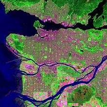
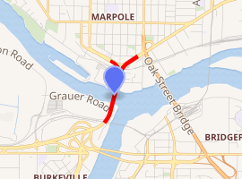
The Arthur Laing Bridge is a crossing over the north arm of the Fraser River, and several minor roads, in Metro Vancouver.
Arthur Laing Bridge | |
|---|---|
 | |
| Coordinates | 49.199317°N 123.135817°W |
| Carries | 4 lanes of Grant McConachie Way, bicycles |
| Crosses | North Arm Fraser River |
| Locale | Richmond Vancouver |
| Maintained by | Vancouver International Airport |
| Preceded by | Marpole Bridge |
| Characteristics | |
| Design | Cantilever bridge |
| Total length | 1676 m |
| Width | 20 m |
| Longest span | 110 m |
| History | |
| Designer | Cochrane Group |
| Opened | August 1975 |
| Statistics | |
| Daily traffic | 79,000[1] |
| |
History
Proposal
The closing of the original Marpole Bridge in 1957 created a more circuitous route between Vancouver and Vancouver International Airport (YVR). Years of debate to restore a direct route followed. In 1963, Arthur Laing, Minister of Northern Affairs and National Resources, announced plans for a toll bridge to be completed within three years. By 1965, he was promoting a tunnel. In 1971, Don Jamieson, Minister of Transport announced a toll-free bridge, but the proposed ramps directly accessing bridges to Lulu Island would not be built. Richmond residents were angry.[2]
On September 6, 1974, Pierre Trudeau announced that the new bridge over the north arm of the Fraser River would be named after Arthur Laing, who was a member of House of Commons of Canada from Vancouver.[3]
Completion and controversy
Although the bridge opened to traffic in August 1975,[4] Otto Lang, Minister of Transport, performed the official opening of the $23m crossing in May 1976.[5] On hand were Premier Bill Bennett, Gil Blair, mayor of Richmond, Art Phillips, mayor of Vancouver, and widow Geraldine Laing, who unveiled a plaque.
Connecting Grant McConachie Way with SW Marine Drive, the bridge is 1,676 metres (5,499 ft) long and 20 metres (66 ft) wide, with a 270-metre (890 ft) main span standing 20 metres (66 ft) above the river.[6] The main span comprises haunched (deeper at supports) steel box-girders and the approaches are concrete box-girders.[7] YVR owns and maintains[8] this high-level four-lane crossing, that has no sidewalks, and cyclists ride on the shoulders of the roadway. Being federal property, signage is in both official languages.[9]
Claiming concerns over increased congestion on Granville St., the City of Vancouver opposed access ramps for Richmond traffic. However, since these commuters were already using the bridge by turning at Aviation Ave., the true impact of ramps would be to reduce travel distance by 3.4 kilometres (2.1 mi), and improve traffic flow on Sea Island. Tom Siddon, member for Burnaby—Richmond—Delta, pressed for the ramps, which opened in 1986.[10]
In 2006, YVR floated a proposal that the bridge be restricted to airport traffic, which provoked a hostile reaction from Richmond city councillors.[11]
Further improvements

In 1987, about 45 percent of the 21,200 square metres (25,355 sq yd) deck was milled to about 20 millimetres (0.8 in) to remove salt-contaminated concrete. After patching, the surface received cathodic protection, before placing a 50 millimetres (2.0 in) thick low-slump dense concrete overlay.[12] The exercise closed half the lanes for four months, and cost about $3m.[13]
In the mid-1990s, the bridge underwent seismic upgrades, which comprised deficient bearings, piers and foundations, and potential soil liquefaction.[14] The work included 800 stone columns installed along either side of the bridge for ground improvement. Richmond, about one metre (3.3 ft) metre above sea level, requires drainage and flood protection. To this end, Grauer Road was raised to 4.7m, which would handle a one-metre rise in sea level. At the road perimeter, the installation of a buried steel sheet pile wall will ensure the bridge piers remain flexible in a seismic event. The road base comprises pumice for light weight and drainage. The project was completed in 2014 for the opening of the McArthurGlen outlet mall.[15]
In 2008, Translink added a bus lane on Russ Baker Way, between Gilbert Road and Cessna Drive. To respond to 127 crashes each year on the bridge, camera monitoring was added and a tow truck stationed at the south end of the bridge during morning rush hour.[16]
_(23678427633).jpg)
In 2014, the adjustment of vehicle lane widths allowed bike-lane widening to improve safety for cyclists.[17][18]
Gliding above
In May 1981, a Cessna 172, that ran out of fuel, crash landed on the bridge deck, but caused no injuries.[13]
Since completion of the north runway in 1996,[19] primarily used for landings, signs have warned bridge traffic of low flying aircraft.
The Middle Arm SkyTrain Bridge, which opened in 2009, passes over the Arthur Laing southern approach.
Transit
The following TransLink service continues to use the bridge:[20]
- N10 Downtown / Richmond–Brighouse Station (night bus; possibly Sep 2009)[21]
N10 Richmond Centre / Downtown (night bus; Sep 2004)[22][23]
The following routes once used the bridge:
- 98 B-Line (Sep 2000 Aylmer Rd. temporary terminus;[24] Dec 2000 Airport Station terminus;[25] Aug 2001 Brighouse new terminus;[26][27][28] Sep 2009 discontinued)[29]
- 100/800 Midway Connector (formerly 800; pre-1979 renumbered;[30] Oct 1984 renamed 100 New Westminster / Airport;[31] pre-Apr 2001 renamed 100 22nd Street Station / Airport Station;[26] Sep 2009 renamed 100 22nd Street Station / Marpole Loop new terminus)[29]
- 402 No. Two Road / Vancouver (May 1986 during peak periods rerouted from Oak Street Bridge;[32] April 2001 renamed 402 Two Road / Bridgeport)[26][27]
- 407 Gilbert / Vancouver (May 1986 during peak periods rerouted from Oak Street Bridge;[32] April 2001 renamed 407 Gilbert / Richmond Centre)[26][27]
- 408 Garden City / Richmond Exchange / Vancouver (May 1986 during peak periods rerouted from Oak Street Bridge;[32] April 2001 discontinued)[26][27]
- 411 Steveston / Vancouver (Dec 1992 peak period express;[33] April 2001 renumbered 491)
- 491 Steveston / One Road / Burrard Station (Aug 2001 peak period express;[26][27][28] Sep 2009 discontinued)[29]
- 496 Railway / Burrard Station (Aug 2001 peak period express;[26][27][28] Sep 2009 discontinued)[29]
- 800 Midway Connector (mid-1976 rerouted from Oak Street Bridge];[34] renumbered 100/800)
The following bus stops on SW Marine Dve., at or opposite Marpole Loop, are nearest:[20]
- N10 Downtown / Richmond (see above)
- 10 Granville (Sep 2003 renumbered on new route pairing)[35]
20 Granville (existed before the bridge)[36] - 100 22nd Street Station / Marpole Loop (see above)
- 480 UBC / Bridgeport Station (since Apr 2011)[37]
480 UBC / Richmond–Brighouse Station) (Sep 2009–Apr 2011)[29]
480 Richmond (Centre) / UBC (Sep 2000–Sep 2009)[38]
480 Steveston / UBC (peak period service Sep–Apr; Sep 1990–Apr 2000;[39] then spring/summer 2000)[40]
480 Richmond (Centre) / UBC (peak period service Sep–Apr; Sep 1980–Mar 1981)[41][42]
The following bus stops on Sea Island, at Airport Station, are nearest:[20]
- N10 Downtown / Richmond (see above)
- 412 Bridgeport Stn/Sea Island South (Aug 2018 renumbered)[43]
C92 Sea Island South / Bridgeport Stn (Sep 2009 new terminus)[29]
C92 Sea Island South / Airport Station (c. May 2005 renumbered and renamed)[44][45]
425 Airport South / Airport Station (Apr 2001 new terminus)[26]
425 Airport South / Richmond Exchange (May 1984 renamed)[46]
425 Sea Island (commencement unclear)
Footnotes
- "Daily Hive, 26 May 2016". www.dailyhive.com.
- Dawe 1996, pp. 56–57.
- "Obituary (Arthur LAING)". www.ubc.ca.
- "The Daily Colonist, 22 Aug 1975". www.archive.org.
- "The Daily Colonist, 16 May 1976". www.archive.org.
- Dawe 1996, p. 62.
- "Structure of the Arthur Laing Bridge". www.structurae.net.
- "Transportation Agencies". www.richmond.ca.
- Dawe 1996, pp. 61–62.
- Dawe 1996, pp. 57–60.
- "CBC News, 8 Sep 2006". www.cbc.ca.
- "Cathodic Protection of the Arthur Laing Bridge". www.concrete.org.
- Dawe 1996, p. 61.
- "Seismic Studies of the Arthur Laing Bridge". www.ausenco.com.
- "Grauer Road dike replacement" (PDF). www.kwl.ca.
- "Vancouver Sun, 20 Nov 2007". www.pressreader.com.
- "Bike lane widening, Arthur Laing Bridge". www.bikehub.ca.
- "Cycling improvements, Arthur Laing Bridge". www.urbansystems.ca.
- "YVR Backgrounder" (PDF). www.theglobeandmail.com. p. 2.
- "Bus routes". www.translink.ca.
- "Buzzer blog, 20 Dec 2010". www.translink.ca. TransLink.
- "The Buzzer, 3 Sep 2004" (PDF). www.translink.ca. TransLink.
- "The Buzzer, 24 Apr 2006" (PDF). www.translink.ca. TransLink.
- "The Buzzer, 1 Sep 2000" (PDF). www.translink.ca. TransLink.
- "The Buzzer, 22 Dec 2000" (PDF). www.translink.ca. TransLink.
- "The Buzzer, 30 Mar 2001" (PDF). www.translink.ca. TransLink.
Bus strike Apr–Aug
- "Implementation of 98 B-line" (PDF). www.richmond.ca.
- "The Buzzer, 8 Aug 2001" (PDF). www.translink.ca. TransLink.
- "The Buzzer, Canada Line opening, 4 Sep 2009". www.translink.ca. TransLink.
- "The Buzzer, 9 Feb 1979" (PDF). www.translink.ca. BC Hydro.
- "The Buzzer, 12 Oct 1984" (PDF). www.translink.ca. Metro Transit.
- "The Buzzer, 30 Apr 1986" (PDF). www.translink.ca. BC Transit.
- "The Buzzer, 4 Dec 1992" (PDF). www.translink.ca. BC Transit.
- "The Buzzer, 24 Sep 1976" (PDF). www.translink.ca. BC Hydro.
- "The Buzzer, 5 Sep 2003" (PDF). www.translink.ca. TransLink.
- "The Buzzer, 6 Sep 1974" (PDF). www.translink.ca. BC Hydro.
- "The Buzzer, 1 Apr 2011". www.translink.ca. TransLink.
- "The Buzzer, 18 Aug 2000" (PDF). www.translink.ca. TransLink.
- "The Buzzer, 24 Aug 1990" (PDF). www.translink.ca. BC Transit.
- "The Buzzer, 31 Mar 2000" (PDF). www.translink.ca. TransLink.
- "The Buzzer, 19 Sep 1980" (PDF). www.translink.ca. Metro Transit.
- "The Buzzer, 18 Sep 1981" (PDF). www.translink.ca. Metro Transit.
- "Buzzer blog, 30 Aug 2018". www.translink.ca. TransLink.
- "Translink route map, c. May 2005". www.researchgate.net.
- "The Buzzer, 1 Sep 2006" (PDF). www.translink.ca. TransLink.
- "The Buzzer, 25 May 1984" (PDF). www.translink.ca. Metro Transit.
References
- Dawe, Alan (1996). Richmond and its Bridges. City of Richmond Archives. ISBN 0-9690031-2-9.CS1 maint: ref=harv (link)