Charlotte County, New Brunswick
Charlotte County (2016 population 25,428[1]) is a county of New Brunswick, Canada.
Charlotte County Comté de Charlotte | |
|---|---|
 | |
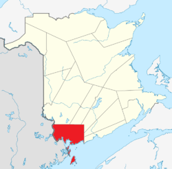 Location within New Brunswick | |
| Coordinates: 45°10′N 66°50′W | |
| Country | |
| Province | |
| Established | 1785 |
| Named for | Charlotte of Mecklenburg-Strelitz |
| Area | |
| • Land | 3,426.97 km2 (1,323.16 sq mi) |
| Population (2016)[1] | |
| • Total | 25,428 |
| • Density | 7.4/km2 (19/sq mi) |
| • Pop 2011-2016 | |
| • Dwellings | 13,513 |
| Time zone | UTC−04:00 (AST) |
| • Summer (DST) | UTC−03:00 (ADT) |
| Area code(s) | 506 |
It was formed in 1784 when New Brunswick was partitioned from Nova Scotia.[2] Once a layer of local government, the county seat was abolished with the New Brunswick Equal Opportunity program in 1966. Counties continue to be used as census subdivisions by Statistics Canada.
It is in the southwestern corner of the province, bordering the US state of Maine. Located at the northern end of the Appalachian Mountains, it has a rugged terrain including Mount Pleasant. The St. Croix, Magaguadavic, and Digdegaush rivers drain into the Bay of Fundy. The county includes the large, populated islands of Grand Manan, White Head, Deer, and Campobello.
Eighteen per cent of the workforce is employed in aquaculture. Connors Bros., the largest sardine canning facility in North America, is located in Blacks Harbour. Cooke Aquaculture is an Atlantic salmon farming company, founded and headquartered in St. George. A paper mill, operated by JD Irving, is in Utopia, and Flakeboard Co Ltd operates outside of St. Stephen.
Governance is in the form of New Brunswick municipalities in the case of the towns of St. Andrews, St. George, and St. Stephen, the villages of Grand Manan and Blacks Harbour, and the rural community of Campobello Island. The remaining parts of the county are administered as local service districts of the Southwest New Brunswick Regional Service Commission, except Clarendon, which is part of RSC 11 in neighbouring Sunbury County.
Census data
Census divisions
| Official name | Designation | Area: km2 (sq mi) | 2016 population[3] |
|---|---|---|---|
| St. Stephen | Town | 13.52 (5.22) | 4,415 |
| Grand Manan | Village | 152.77 (58.98) | 2,360 |
| St. Andrews | Town | 8.35 (3.22) | 1,786 |
| St. George | Town | 16.17 (6.24) | 1,517 |
| Saint George | Parish | 2,141 | |
| Pennfield | Parish | 2,170 | |
| Saint Stephen | Parish | 1,839 | |
| Saint David | Parish | 1,529 | |
| Saint James | Parish | 1,186 | |
| Fundy Bay | LSD | 60.24 | 1,167 |
| Dennis-Weston | LSD | 43.94 | 1,023 |
| Blacks Harbour | Village | 9.06 (3.50) | 894 |
| Campobello Island | Rural community | 39.67 (15.32) | 872 |
| West Isles | Parish | 797 | |
| Lepreau | Parish | 707 | |
| Saint Patrick | Parish | 689 | |
| Saint Croix | Parish | 657 | |
| Dufferin | Parish | 573 | |
| Saint Andrews | Parish | 553 | |
| Western Charlotte part B | LSD | 28.97 | 534 |
| Western Charlotte part A | LSD | 162.3 | 435 |
| Dumbarton | Parish | 335 | |
| Beaver Harbour | LSD | 2.25 | 277 |
| Grand Manan | Parish | 145 | |
| Clarendon | Parish | 63 |
Population
| Canada census – Charlotte County, New Brunswick community profile | |||
|---|---|---|---|
| 2016 | 2011 | 2006 | |
| Population: | 25,428 (-4.2% from 2011) | 26,549 (-1.3% from 2006) | 26,898 (-1.7% from 2001) |
| Land area: | 3,426.97 km2 (1,323.16 sq mi) | 3,424.33 km2 (1,322.14 sq mi) | 3,423.52 km2 (1,321.83 sq mi) |
| Population density: | 7.4/km2 (19/sq mi) | 7.8/km2 (20/sq mi) | 7.9/km2 (20/sq mi) |
| Median age: | 47.9 (M: 47.0, F: 48.8) | 45.1 (M: 44.0, F: 46.0) | 42.2 (M: 41.3, F: 43.0) |
| Total private dwellings: | 13,513 | 13,486 | 13,392 |
| Median household income: | $55,701 | $48,953 | $40,897 |
| References: 2016[3] 2011[4] 2006[5] earlier[6] | |||
| Historical Census Data - Charlotte County, New Brunswick | |||||||||||||||||||||||||||||
|---|---|---|---|---|---|---|---|---|---|---|---|---|---|---|---|---|---|---|---|---|---|---|---|---|---|---|---|---|---|
|
|
| |||||||||||||||||||||||||||
| [7][8][1] | |||||||||||||||||||||||||||||
Language
| Canada Census Mother Tongue - Charlotte County, New Brunswick[7] | ||||||||||||||||||
|---|---|---|---|---|---|---|---|---|---|---|---|---|---|---|---|---|---|---|
| Census | Total | English |
French |
English & French |
Other | |||||||||||||
| Year | Responses | Count | Trend | Pop % | Count | Trend | Pop % | Count | Trend | Pop % | Count | Trend | Pop % | |||||
2011 |
26,185 |
25,015 | 95.53% | 610 | 2.33% | 55 | 0.21% | 505 | 1.93% | |||||||||
2006 |
26,620 |
25,625 | 96.26% | 570 | 2.14% | 25 | 0.10% | 400 | 1.50% | |||||||||
2001 |
27,020 |
26,100 | 96.59% | 675 | 2.50% | 35 | 0.13% | 210 | 0.78% | |||||||||
1996 |
26,990 |
26,150 | n/a | 96.89% | 545 | n/a | 2.02% | 45 | n/a | 0.17% | 250 | n/a | 0.93% | |||||
Infrastructure
Power generation
Hydroelectric dams operate in St. George and St. Stephen, though the latter is being decommissioned.
See also
References
- "Census Profile, 2016 Census: Charlotte, County [Census division], New Brunswick". Statistics Canada. Retrieved 7 September 2019.
- Slumkoski, Corey (2005). "The Partition of Nova Scotia". The Winslow Papers. Electronic text centre (UNB Libraries). Retrieved 5 May 2020.
- "2016 Community Profiles". 2016 Canadian Census. Statistics Canada. 21 February 2017. Retrieved 7 September 2019.
- "2011 Community Profiles". 2011 Canadian Census. Statistics Canada. 5 July 2013. Retrieved 26 March 2014.
- "2006 Community Profiles". 2006 Canadian Census. Statistics Canada. 30 March 2011. Retrieved 26 March 2014.
- "2001 Community Profiles". 2001 Canadian Census. Statistics Canada. 17 February 2012.
- Statistics Canada: 1996, 2001, 2006, 2011 census
- 2011 Statistics Canada Census Profile: Charlotte County, New Brunswick
Places adjacent to Charlotte County, New Brunswick | |
|---|---|
| Subdivisions |
|
|---|---|
| Cities | |
| Counties | |
| |