Campobello Island
Campobello Island (/ˌkæmpəˈbɛloʊ/,[2][3] also US: /-poʊˈ-/)[4] is the largest and only inhabited island in Campobello Parish, a civil parish[lower-alpha 1] in southwestern New Brunswick, near the border with Maine.[5] It has been governed as an incorporated rural community since 2010; despite the name, the rural community also includes all other islands in the parish. The island's permanent population in 2016 was 872.[6] It is the site of the Roosevelt Campobello International Park and of Herring Cove Provincial Park.
Campobello Island Île Campobello | |
|---|---|
Rural Community | |
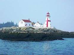 Head Harbour Light Station, Passamaquoddy Bay | |
 Campobello Island Location of Campobello Island in Canada 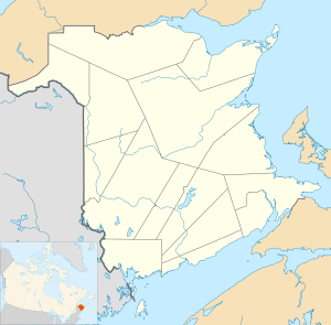 Campobello Island Campobello Island (New Brunswick) | |
| Coordinates: 44°53′N 66°56′W | |
| Country | |
| Province | |
| County | Charlotte County |
| Established | 1803 |
| Area | |
| • Land | 39.67 km2 (15.32 sq mi) |
| Highest elevation | 90 m (300 ft) |
| Lowest elevation | 0 m (0 ft) |
| Population (2016) | |
| • Total | 872 |
| • Density | 22.0/km2 (57/sq mi) |
| • Pop 2011-2016 | |
| • Pop 2011-2016 density | 22/km2 (60/sq mi) |
| • Dwellings | 616 |
| Time zone | UTC-4 (AST) |
| • Summer (DST) | UTC-3 (ADT) |
The island is part of Charlotte County, which was formed in 1784 when New Brunswick was partitioned from Nova Scotia.[7] Campobello Parish was part of West Isles Parish until 1803, when it was erected as a separate parish. Campobello was claimed by the United States until the boundary in Passamaquoddy Bay was settled by commission in 1817.[8]
History
The island was originally settled by the Passamaquoddy Nation, who called it Ebaghuit.
The first Europeans were from the French expedition of Pierre Dugua de Mons and Samuel de Champlain, who founded the nearby Saint Croix Island settlement in 1604. France named the island Port aux Coquilles ("Seashell Harbour").
Following the War of the Spanish Succession, under terms of the Treaty of Utrecht (1713), the island became part of the British colony of Nova Scotia.

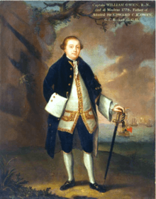
In 1770, a grant of the island was made to Captain William Owen of the Royal Navy, who renamed it Campobello.
The population was increased by United Empire Loyalists after the American Revolutionary War. Smuggling was a major part of the island's prosperity around this time. During the War of 1812 the Royal Navy seized coastal lands of Maine as far south as the Penobscot River but returned them following the war, except for offshore islands. In 1817, the United States relinquished its claim to Campobello, Deer, and Grand Manan) islands, in exchange for islands in Cobscook Bay.
In 1866, a band of more than 700 members of the Fenian Brotherhood arrived at the Maine shore opposite the island with the intention of seizing Campobello[9] but were dispersed by British warships from Halifax.[10]
British naval officer John James Robinson became owner of the island in 1857. In 1881 it was sold to a group of American businessmen, including James Roosevelt. In the 1880s the island was developed as a resort summer colony for wealthy Canadians and Americans, as was nearby St. Andrews, New Brunswick and Bar Harbor, Maine. A luxurious resort hotel and many grand estates were built.[11] From 1883, the Roosevelt family made Campobello Island their summer home.
By the mid-1800s, Campobello Island had a population in excess of 1,000, which grew to 1,230 by 1910.
Geography
The island is at the entrance to Passamaquoddy Bay, adjacent to the entrance to Cobscook Bay, and within the Bay of Fundy. The island is one of the Fundy Islands. The island has no road connection to the rest of Canada; it is connected by the Franklin Delano Roosevelt Bridge to nearby Lubec, Maine. Reaching mainland Canada by car without crossing an international border is possible only during the summer season and requires two separate ferry trips, first to nearby Deer Island, then to L'Etete.[12] The ferry to Deer Island stopped in 2017, leaving the island without a direct connection to the rest of Canada.[13]
The jurisdiction of the eponymous rural community and of the census division include Head Harbour Island.
Measuring 14 kilometres (8.7 mi) long and about five kilometres (3.1 mi) wide, it has an area of 39.6 square kilometres (15.3 sq mi). On the north is a high bluff headland, East Quoddy Point.[14] On the west are Charley Point and the Mulholland Point navigation light.[14]
Economy
The island has several good harbours,[15] and the majority of residents are employed in the fishing, aquaculture or tourism industries.
The two major tourist attractions on the island are Herring Cove Provincial Park and Roosevelt Campobello International Park. The latter was created in 1964 and was officially opened by U.S. President Lyndon Johnson and Canadian Prime Minister Lester Pearson in 1966.
Infrastructure
The island's only highway, Route 774, is connected by the Franklin Delano Roosevelt Bridge to Lubec, Maine – the easternmost town in the continental United States. The only transportation link with the rest of Canada is a seasonal ferry service to Deer Island Point, New Brunswick, on Deer Island.[16]
Mail delivered to the community goes through the United States. The U.S. began searching packages to/from the island in 2019, prompting outcry from residents.[17][18]
Education
The island has one school, Campobello Island Consolidated School, for all school grades, in the Anglophone South School District.
Census data
Population
| Canada census – Campobello Island community profile | |||
|---|---|---|---|
| 2016 | 2011 | 2006 | |
| Population: | 872 (-5.7% from 2011) | 925 (-12.4% from 2006) | 1,056 (-11.6% from 2001) |
| Land area: | 39.67 km2 (15.32 sq mi) | 39.67 km2 (15.32 sq mi) | 39.59 km2 (15.29 sq mi) |
| Population density: | 22.0/km2 (57/sq mi) | 23.3/km2 (60/sq mi) | 26.7/km2 (69/sq mi) |
| Median age: | 48.4 (M: 48.2, F: 48.4) | 46.0 (M: 46.1, F: 45.9) | 43.4 (M: 43.3, F: 43.5) |
| Total private dwellings: | 616 | 641 | 632 |
| Median household income: | $52,139 | $38,159 | |
| References: 2016[19] 2011[20] 2006[21] earlier[22] | |||
| Historical Census Data Campobello Parish, NB | |||||||||||||||||||||||||||||
|---|---|---|---|---|---|---|---|---|---|---|---|---|---|---|---|---|---|---|---|---|---|---|---|---|---|---|---|---|---|
|
|
| |||||||||||||||||||||||||||
| [23][1] | |||||||||||||||||||||||||||||
Language
| Canada Census Mother Tongue - Campobello Parish, New Brunswick[23] | ||||||||||||||||||
|---|---|---|---|---|---|---|---|---|---|---|---|---|---|---|---|---|---|---|
| Census | Total | English |
French |
English & French |
Other | |||||||||||||
| Year | Responses | Count | Trend | Pop % | Count | Trend | Pop % | Count | Trend | Pop % | Count | Trend | Pop % | |||||
2011 |
895 |
885 | 98.88% | 5 | 0.56% | 0 | 0.00% | 5 | 0.56% | |||||||||
2006 |
1,035 |
985 | 95.17% | 30 | 2.90% | 0 | 0.00% | 20 | 1.93% | |||||||||
2001 |
1,165 |
1,165 | 100.00% | 0 | 0.00% | 0 | 0.00% | 0 | 0.00% | |||||||||
1996 |
1,280 |
1,280 | n/a | 100.00% | 0 | n/a | 0.00% | 0 | n/a | 0.00% | 0 | n/a | 0.00% | |||||
Notes
- Civil parishes were used to organise the province for various administrative purposes, including representation on county councils. The Municipalities Act of 1966 abolished county councils and civil parishes lost most of their functions. Parishes continue to provide convenient boundaries for federal and provincial electoral districts. Statistics Canada uses civil parishes as census subdivisions for all parts of the province that are not within municipalities and similar entities.
References
- "Census Profile, 2016 Census: Campobello Island, Rural community [Census subdivision]". Statistics Canada. Retrieved 26 August 2019.
- "Campobello Island". Lexico UK Dictionary. Oxford University Press. Retrieved 28 July 2019.
- "Campobello". Merriam-Webster Dictionary. Retrieved 28 July 2019.
- "Campobello". Collins English Dictionary. HarperCollins. Retrieved 28 July 2019.
- Community Profile: Campobello Parish, Charlotte County, New Brunswick; Statistics Canada.
- "Census Profile, 2016 Census: Campobello Island". Statistics Canada. Retrieved 10 August 2019.
- Slumkoski, Corey (2005). "The Partition of Nova Scotia". The Winslow Papers. Electronic text centre (UNB Libraries). Retrieved 5 May 2020.
- Edwards, M.J. (Ed.) (July 2013). Grand Manan & the War of 1812 (PDF). Grand Manan Museum. p. 14. Retrieved 24 June 2020.CS1 maint: extra text: authors list (link)
- Jennifer Crump (26 July 2010). Canada Under Attack. Dundurn. p. 133. ISBN 9781459704879.
- Buescher, John. "What Happened to the Fenians After 1866?" Teachinghistory.org, accessed 8 October 2011
- Erika J. Waters (2010). Kittery to Bar Harbor: Touring Coastal Maine. Arcadia Publishing. p. 119. ISBN 9780738572819.
- Paul Karr (18 March 2005). Frommer'sMaine Coast. John Wiley & Sons. p. 248. ISBN 9780764595974.
- O'Connor, Joe (23 January 2018). "The island Canada forgot: On Campobello, citizens are left exiles in their own land". Financial Post. Retrieved 24 January 2019.
- U.S. Coast and Geodetic Survey (1879). Atlantic Local Coast Pilot: Sub-division 1: Passamaquoddy Bay to Schoodic. U.S. Government Printing Office. p. 15.
- Richardson Clover (1891). Sailing Directions for Nova Scotia, Bay of Fundy, and South Shore of Gulf of St. Lawrence. U.S. Government Printing Office. p. 29.
- David Goss (2002). St. George and Its Neighbours. Arcadia Publishing. p. 91. ISBN 9780738511498.
- "Canadian islanders angry over US mail searches". BBC. Retrieved 1 December 2019.
- "On quiet Campobello Island, Canadians angered by US inspection of their mail". Boston Globe. Retrieved 20 January 2020.
- "2016 Community Profiles". 2016 Canadian Census. Statistics Canada. 21 February 2017. Retrieved 26 August 2019.
- "2011 Community Profiles". 2011 Canadian Census. Statistics Canada. 5 July 2013. Retrieved 15 March 2014.
- "2006 Community Profiles". 2006 Canadian Census. Statistics Canada. 30 March 2011. Retrieved 15 March 2014.
- "2001 Community Profiles". 2001 Canadian Census. Statistics Canada. 17 February 2012.
- Statistics Canada: 1996, 2001, 2006, 2011 census
External links
| Wikimedia Commons has media related to Campobello Island. |
- "Campobello Island", Tourism New Brunswick, Canada
- "Campobello Island", in the international Quoddy Loop
- "Campobello Island", The Canadian Encyclopedia
- Roosevelt Campobello International Park
| Subdivisions |
|
|---|---|
| Cities | |
| Rural communities | |
| |
| Authority control |
|
|---|