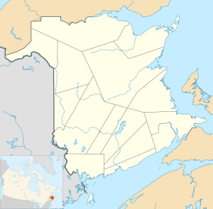
St. Andrews, New Brunswick
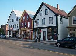
Saint Andrews (2016 population: 1,786)[1] is a town in Charlotte County, New Brunswick, Canada. The historic town is well preserved, and is a national historic site of Canada, bearing many characteristics of a typical 18th century British colonial settlement.
Saint Andrews Saint-Andrews | |
|---|---|
Town | |
 Historic town centre | |
| Nickname(s): Saint Andrews By-the-Sea | |
 Saint Andrews | |
| Coordinates: 45.07399°N 67.05209°W | |
| Country | |
| Province | |
| County | Charlotte |
| Settled | 1783 |
| Incorporated | 1903 |
| Named for | Saint Andrew's Day |
| Government | |
| • Type | New Brunswick Municipality |
| • Mayor | Doug Naish |
| • Deputy Mayor | Brad Henderson |
| • Councillors | Guy Groulx, Kurt Gumushel, Edie Bishop, Andrew Harrison, Kate Akagi |
| • CAO | Chris Spear |
| Area | |
| • Land | 8.35 km2 (3.22 sq mi) |
| Population (2016)[2] | |
| • Total | 1,786 |
| • Density | 213.9/km2 (554/sq mi) |
| Time zone | UTC-4 (Atlantic (AST)) |
| • Summer (DST) | UTC-3 (ADT) |
| Canadian Postal code | E5B |
| Area code(s) | 506 |
| Telephone Exchange | 529 |
| NTS Map | 021G03 |
| GNBC Code | DAEBC |
| Website | http://www.townofstandrews.ca/ |
History
At the eastern end the town is a midden, a pile of shells and other refuse that accumulated over two thousand years due to year-round activity of the indigenous peoples in Canada. It is today a provincial heritage site.[3]
The site of the town was named Qunnnoskwamk'ook, meaning long gravel bar in the Malecite-Passamaquoddy language. The present name was given by a French missionary who landed at the site on Saint Andrew's Day.[4] The site was settled in 1783 by United Empire Loyalists, and the town's street grid, designed by Charles Morris, was laid out at that time and persists today.[5] Except for the shoreline Water Street, all street names have royal or colonial associations.[6] Also typical of British colonial settlement of the time are the defensive sites, public spaces, and delineation of the town.[5]
Between 1820 and 1860, the port of Saint Andrews welcomed Irish immigrants. They were first quarantined at Hospital Island, in Passamaquoddy Bay. At the 1851 census, more than 50% of the town's population had been born in Ireland.[8]
The Pendlebury Lighthouse, also known as the St. Andrews North Point Lighthouse, was built in 1833 at the tip of the peninsula.[9] It was deactivated in 1938, and has since been restored and registered as a Canadian historic place.
In 1840, the Charlotte County Court House was built, and is still in use.[10]
In the late 1800s and early 1900s St Andrews became a seaside resort for people from Montreal and Boston seeking to escape the summer heat.[6] The town's first seaside hotel, the Argyll, opened in 1881[11] followed in 1889 by The Algonquin, a resort on a hill overlooking the town, making Saint Andrews Canada's first seaside resort.[12] The Argyll burned down in 1892 and was never rebuilt and the Algonquin burned in 1914 but was rebuilt one year later. The lifestyle of wealthy summer visitors is commemorated at the Ross Memorial Museum.[13]
A federal marine research facility, the St. Andrews Biological Station, was established in 1908.[6] and the Huntsman Marine Science Centre in 1969.[14]
The town, having flourished in the early 1800s, and having seen little development since then, nor modern industrial activity, is well preserved. In 1998 it was designated a national historic site.
| Year | 1901 | 1911 | 1921 | 1931 | 1941 | 1951 | 1961 | 1981 | 1986 | 1991 | 1996 | 2001 | 2006 | 2011 | 2016 |
|---|---|---|---|---|---|---|---|---|---|---|---|---|---|---|---|
| Population | 1064 | 987 | 1065 | 1207 | 1167 | 1458 | 1531 | 1760 | 1612 | 1652 | 1752 | 1869 | 1798 | 1889 | 1786 |
Geography
Saint Andrews is at the southern tip of a peninsula, extending into Passamaquoddy Bay. The waterfront faces Saint Andrews Harbour and the Western Channel, which is formed by Navy Island. The harbour is at the mouth of the St. Croix River.
The town is directly opposite the community of Robbinston, Maine, 2 kilometres to the west across the river mouth, and 53 km by road.
Ministers Island is east of the town and is accessible by road at low tide only.[15]
| St. Andrews | ||||||||||||||||||||||||||||||||||||||||||||||||||||||||||||
|---|---|---|---|---|---|---|---|---|---|---|---|---|---|---|---|---|---|---|---|---|---|---|---|---|---|---|---|---|---|---|---|---|---|---|---|---|---|---|---|---|---|---|---|---|---|---|---|---|---|---|---|---|---|---|---|---|---|---|---|---|
| Climate chart (explanation) | ||||||||||||||||||||||||||||||||||||||||||||||||||||||||||||
| ||||||||||||||||||||||||||||||||||||||||||||||||||||||||||||
| ||||||||||||||||||||||||||||||||||||||||||||||||||||||||||||
Transportation
Despite its proximity to the Canada–United States border, the nearest border crossings are 30 km away at St. Stephen or via a ferry service at Deer Island.
The only way into or out of Saint Andrews by land is via Route 127, which runs directly through the town. It meets Route 1 on either end of the town.
Media
A local community channel, CHCO, serves the Saint Andrews and Charlotte County area. The station launched in 1993 on cable television, and began broadcasting over the air in 2006.
Education
- NBCC St. Andrews [16]
- Vincent Massey Elementary School (K-5)
- Sir James Dunn Academy (6-12)[17]
Gallery
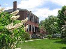 Ross Museum
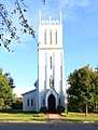 All Saints Anglican Church is the oldest established church in city proper limits.
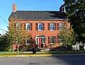 Sheriff Andrews House, a museum
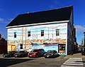 Saint Andrews features many outdoor murals
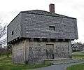
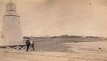 St. Andrews Lighthouse
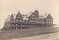 The original Algonquin hotel
References
- "Census Profile, 2016 Census: Saint Andrews, New Brunswick". Statistics Canada. Retrieved 14 August 2019.
- https://www12.statcan.gc.ca/census-recensement/2016/dp-pd/prof/details/page.cfm?Lang=E&Geo1=CSD&Code1=1302026&Geo2=PR&Code2=13&SearchText=Saint%20Andrews&SearchType=Begins&SearchPR=01&B1=All&TABID=1&type=0; retrieved: 20 June 2020.
- "Pagan Point". www.historicplaces.ca. Retrieved 6 June 2020.
- "St. Andrews". Provincial Archives of New Brunswick. Retrieved 21 June 2020.
- "St. Andrews Historic District National Historic Site of Canada". www.pc.gc.ca. Government of Canada. Retrieved 6 June 2020.
- "Our Heritage". St. Andrews by-the-Sea. Retrieved 6 June 2020.
- Parks Canada Agency, Government of Canada (1 June 2020). "St. Andrews Blockhouse National Historic Site". www.pc.gc.ca. Retrieved 6 June 2020.
- Irish Canadian Cultural Association of New Brunswick Archived 2009-07-26 at the Wayback Machine
- "Pendlebury Lighthouse". www.historicplaces.ca. Retrieved 7 June 2020.
- "Charlotte County Court House". www.historicplaces.ca. Retrieved 6 June 2020.
- David Sullivan, Argyll Hotel, Old New Brunswick, Accessed August 23, 2016
- "Heritage, Arts & Culture". Town of Saint Andrews. Retrieved 6 June 2020.
- "Ross Memorial Museum". Retrieved 6 June 2020.
- "Huntsman Marine Science Centre". Huntsman Marine Science Centre. Retrieved 6 June 2020.
- "The Van Horne Estate on Ministers Island, Crossing Tides & Time, A Unique Canadian Maritime Coastal Experience, St Andrews by the sea, New Brunswick, Canada". ministersisland.net. Retrieved 6 June 2020.
- NBCC St. Andrews, Campus of New Brunswick Community College.
- Schools in Anglophone South School District
External links
| Wikimedia Commons has media related to St. Andrews, New Brunswick. |
| Subdivisions |
|
|---|---|
| Cities | |
| Towns | |
| |