Upper Mississippi River National Wildlife and Fish Refuge
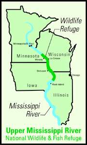
The Upper Mississippi River National Wildlife and Fish Refuge is a 240,000-acre (970 km2),[2] 261-mile long (420 km) National Wildlife Refuge located in and along the Upper Mississippi River. It runs from Wabasha, Minnesota in the north to Rock Island, Illinois in the south.
| Upper Mississippi River National Wildlife and Fish Refuge | |
|---|---|
IUCN category IV (habitat/species management area) | |
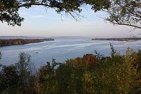 Looking west over the Mississippi River from an overlook within the Upper Mississippi River National Wildlife and Fish Refuge | |
 Map of the United States | |
| Location | Illinois, Iowa, Minnesota, Wisconsin, United States |
| Nearest city | Dubuque, Iowa |
| Coordinates | 42°53′00″N 91°06′00″W |
| Area | 240,000 acres (970 km2) |
| Established | 1924 |
| Governing body | U.S. Fish and Wildlife Service |
| Website | Upper Mississippi River National Wildlife and Fish Refuge |
| Official name | Upper Mississippi River Floodplain Wetlands |
| Designated | 1 May 2010 |
| Reference no. | 1901[1] |
In its northern portion, it is in the Driftless Area, a region of North America that remained free from ice during the last ice age. Certain parcels contained within the refuge were later transferred to the Driftless Area National Wildlife Refuge.
The refuge is an important element of the Mississippi Flyway. It has many wooded islands, sloughs, and hardwood forests. The wildlife found here include the canvasback duck, tundra swan, white-tailed deer, and muskrat. Recreational activities include boating, hunting, fishing, and swimming.
Refuge Headquarters are located in Winona, Minnesota, with district offices located in La Crosse, Wisconsin, Prairie du Chien, Wisconsin, and Thomson, Illinois.
Geography
The refuge is one of only two that spans portions of four states (the other is Silvio O. Conte National Fish and Wildlife Refuge). As of 30 September 2007 the area per state was: Wisconsin: 89,637.54 acres (362.75 km2), Iowa: 51,147.78 acres (206.99 km2), Minnesota: 33,868.64 acres (137.06 km2), Illinois: 33,489.57 acres (135.53 km2).[3]
The following counties border on or have land within the Upper Mississippi River National Wildlife and Fish Refuge. In each state, the counties are listed from north to south. The lakes and rivers within the refuge area of each county are also listed.
Minnesota
- Wabasha County
- Cross Lake
- Half Moon Lake
- Maloney Lake
- McCarthy Lake
- Peterson Lake
- Robinson Lake
- Zumbro River
- Winona County
- Houston County
- Blue Lake
- Hayshore Lake
- Lawrence Lake
- Root River
- Target Lake
Wisconsin
.jpg)
See also
- Izaak Walton League
- List of National Wildlife Refuges
- Trempealeau National Wildlife Refuge
- Upper Mississippi River Locks and Dams
References
- "Upper Mississippi River Floodplain Wetlands". Ramsar Sites Information Service. Retrieved 25 April 2018.
- Upper Mississippi River National Wildlife & Fish Refuge, Retrieved July 15, 2007
- U.S. Fish and Wildlife Service. "National Wildlife Refuge System".
![]()
External links
| Wikimedia Commons has media related to Upper Mississippi River National Wildlife and Fish Refuge. |
- Upper Mississippi River National Wildlife and Fish Refuge
- Stewards of the Upper Mississippi River Wildlife and Fish Refuge
| Authority control |
|
|---|