Qilian Mountains
The Qilian Mountains (simplified Chinese: 祁连山; traditional Chinese: 祁連山; pinyin: Qílián Shān; Wade–Giles: Ch'i2-lien2 Shan1, also romanized as Tsilien; Mongghul: Chileb), together with the Altyn-Tagh (Altun Shan) also known as Nan Shan (Chinese: 南山, literally "Southern Mountains"), as it is to the south of Hexi Corridor, is a northern outlier of the Kunlun Mountains, forming the border between Qinghai and the Gansu provinces of northern China.[1]
| Qilian Mountains | |
|---|---|
| 祁連山 | |
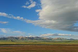 Qilian Mountains in Qilian County, Qinghai | |
| Highest point | |
| Peak | Kangze'gyai |
| Elevation | 5,808 m (19,055 ft) |
| Geography | |
 | |
| Location | Gansu and Qinghai provinces, China |
Geography
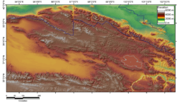
The range stretches from the south of Dunhuang some 800 km to the southeast, forming the northeastern escarpment of the Tibetan Plateau and the southwestern border of the Hexi Corridor.
The eponymous Qilian Shan peak, situated some 60 km south of Jiuquan, at 39°12′N 98°32′E, rises to 5,547 m. It is the highest peak of the main range, but there are two higher peaks further south, Kangze'gyai at 38°30′N 97°43′E with 5,808 m and Qaidam Shan peak at 38°2′N 95°19′E with 5,759 m. Other major peaks include Gangshiqia Peak in the east.
The Nan-Shan range continues to the west as Yema Shan (5,250 m) and Altun Shan (Altyn Tagh) (5,798 m). To the east, it passes north of Qinghai Lake, terminating as Daban Shan and Xinglong Shan near Lanzhou, with Maoma Shan peak (4,070 m) an eastern outlier. Sections of the Ming Dynasty's Great Wall pass along its northern slopes, and south of northern outlier Longshou Shan (3,616 m).
The Qilian mountains are the source of numerous, mostly small, rivers and creeks that flow northeast, enabling irrigated agriculture in the Hexi Corridor (Gansu Corridor) communities, and eventually disappearing in the Alashan Desert. The best known of these streams is the Ejin (Heihe) River. The region has many glaciers, the largest of which is the Touming Mengke.[2] These glaciers have undergone acceleration in their melting in recent decades.[3]
The characteristic ecosystem of the Qilian Mountains has been described by the World Wildlife Fund as the Qilian Mountains conifer forests.[4]
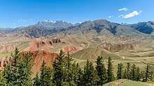
Biandukou (扁都口), with an altitude of over 3500 m, is a pass in the Qilian Mountains. It links Minle County of Gansu in the north and Qilian County of Qinghai in the south.[5]
History
The Shiji mentions the "Qilian mountains" together with Dunhuang in relation to the homeland of the Yuezhi. This Qilian however has been suggested to be the mountains now known as Tian Shan, 1,500 km to the west.[6] Dunhuang has also been argued to be the Dunhong mountain.[7] Qilian (祁连) is said to be a Xiongnu word meaning "sky" (Chinese: 天) according to Yan Shigu, a Tang Dynasty commentator on the Hanshu.[8]
The Tuyuhun were based around the Qilian mountains.
The mountain range was formerly known in European languages as Richthofen Range after Ferdinand von Richthofen, who was the Red Baron's explorer-geologist uncle.[9]
The mountain range gives its name to Qinghai's Qilian County.
References
- Association for Asian Studies, Far Eastern Association (U.S.) (2003). The Journal of Asian studies, Volume 62, Issue 1. Association for Asian Studies. p. 262. ISBN 0-691-09676-7. Retrieved 2010-06-28.
-
2012-07-15. "Top 6 most beautiful glaciers in China". China Daily. Retrieved 2017-04-18.
It can be found in Laohu Valley on the northern slope of Daxue Mountain in Subei County.
CS1 maint: numeric names: authors list (link) - Edward Wong (2015-12-08). "Chinese Glacier's Retreat Signals Trouble for Asian Water Supply". New York Times. p. A4. Retrieved 2017-04-18.
- "Qilian Mountains conifer forests". Terrestrial Ecoregions. World Wildlife Fund.
- "扁都口旅游景区开发项目" [Flat mouth tourist area development project] (in Chinese). Xinhua. 2005-12-20. Archived from the original on 2016-03-04. Retrieved 2017-04-18.
- Mallory, J. P. & Mair, Victor H. (2000). The Tarim Mummies: Ancient China and the Mystery of the Earliest Peoples from the West. Thames & Hudson. London. p. 58. ISBN 0-500-05101-1.
- Liu, Xinru, Migration and Settlement of the Yuezhi-Kushan: Interaction and Interdependence of Nomadic and Sedentary Societies (2001)
- 班固. 漢書: 顏師古註.
祁連山即天山也,匈奴呼天為祁連 (translation: Qilian Mountain is the Tian Shan, the Xiongnu called the sky qilian)
- Winchester, Simon. (2008). The Man Who Loved China: the Fantastic Story of the Eccentric Scientist Who Unlocked the Mysteries of the Middle Kingdom, p. 126.
External links
- Winchester, Simon. (2008). The Man Who Loved China: the Fantastic Story of the Eccentric Scientist Who Unlocked the Mysteries of the Middle Kingdom. New York: Harper. ISBN 978-0-06-088459-8

- peakbagger.com
- Climatological Information (Reference) for Qilian Shan
Gansu topics | |
|---|---|
Lanzhou (capital) | |
| General | |
| Geography | |
| Education |
|
| Culture | |
| Cuisine |
|
| Visitor attractions |
|
| |