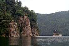
Changbai Mountains
The Changbai Mountains (Chinese: 长白山; pinyin: Chángbái Shān) are a major mountain range in Northeast Asia. The mountains extend from the Northeast Chinese provinces of Heilongjiang, Jilin and Liaoning, across the border between China and North Korea (41°41' to 42°51'N; 127°43' to 128°16'E), to the North Korean provinces of Ryanggang and Chagang. They are also referred to as the Šanggiyan, Jangbaek or Ohnan mountains. Most peaks exceed 2,000 metres (6,600 feet) in height, with the highest being the Changbai Mountain.
Animal resources
There are 1,225 species known in the Changbai Mountains, which belong to 73 orders and 219 families. Among them, forest insect pests 6 orders 48 families 387 species; forest inosect natural enemies 7 orders 29 families 94 species; vertebrates 60 orders 142 families 744 species. Among the 1,225 kinds of wild animals, there are 43 kinds of animals under national key protection. Among them, the national first-level protected animals include Siberian tiger, leopard, sika deer, sable, black stork and golden eagle. National secondary protected animals include Chinese Merganser, jackal, musk deer, black bear, brown bear, otter, lynx, red deer, green sheep (gazelle), owl, kite, bee eagle, goshawk, sparrow hawk, hazel hawk 37 kinds.
History
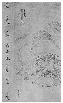
The range represents the mythical birthplace of Bukūri Yongšon, ancestor of Nurgaci[1] and the Aisin Gioro imperial family, who were the founders of the Manchu state and the Qing dynasty of China. The Chinese name literally means "Perpetually-White Mountain Region".[2]
Geography and climate
The geological formation is when it was basically formed about 4.5 billion years ago, a gap appeared at a point in the eastern hemisphere. This gap is the entire Changbai Mountain area.
The southern part of the mountain belongs to the quasi platform of China and North Korea, and the northern part belongs to the Jihehualixi fold belt. The Yanshanian movement[3] unified the north-south tectonic directions and formed the basis of the Chinese mountain. In the Tertiary Himalayan movement,[4] large-scale torsion and breaking of blocks occurred, accompanied by massive basalt ejection. The mountainous area is mainly composed of granite, basalt, gneiss and schist, while granite has the widest distribution area. Basalt is mainly distributed in Mudanjiang River and around Changbai Mountain
The mountains are the source of the Songhua, Tumen, and Yalu Rivers.[5]
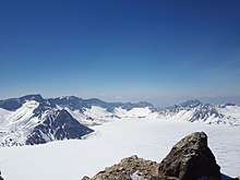
The Changbai Mountains are characterized by long and cold winters. Precipitation is low in the winter but higher in the summer and autumn with annual averages reaching as high as 1,400 millimetres (55 inches).[6]
Flora and fauna
The vegetation of the mountain slopes is divided into several different zones. At the top, above 2,000 metres, tundra predominates. From 1,700 to 2,000 metres, vegetation is dominated by mountain birch and larch. Below this zone, and down to 1,100 metres, the dominant trees are spruce, fir, and Korean pine. From 600 to 1,100 metres, the landscape is dominated by mixed forest, consisting of Amur linden, Korean pine, maple, and elm. Further down, a temperate hardwood forest is found, dominated by second-growth poplar and birch.[7]
Protected areas
See also
- Baekdu Mountain
- Changbai Waterfall
- List of mountains in Korea
References
- 愛新覺羅·瀛生《滿語口語音典》
- Crossley, Pamela Kyle (February 2000). A Translucent Mirror: History and Identity in Qing Imperial Ideology. University of California Press. p. 202. ISBN 9780520234246.
- Wang, Yu; Sun, Lixin; Zhou, Liyun; Xie, Yueting (2018-05-01). "Discussion on the relationship between the Yanshanian Movement and cratonic destruction in North China". Science China Earth Sciences. 61 (5): 499–514. doi:10.1007/s11430-017-9177-2. ISSN 1869-1897.
- "Formation of the Himalayas". www.edumedia-sciences.com. Retrieved 2020-04-15.
- "Changbai Mountains -- Scenic Wonderland". China.org.cn. Retrieved 12 July 2014.
- "Changbai Mountains mixed forests (PA0414)". WildWorld Ecoregion Profile, National Geographic Society. World Wildlife Fund. Archived from the original on 2010-03-08. Retrieved 9 February 2015.
- Liu, Q.J., Takamura, T., Takeuchi, N., Shao, G. (2002). Mapping of boreal vegetation of a temperate mountain in China by multitemporal LANDSAT imagery. International Journal of Remote Sensing 23(17), p. 3388
External links
| Wikimedia Commons has media related to Changbai / Paektu Mountains. |
Mountain ranges of China | |
|---|---|
| Northwest China | |
| Qinghai-Tibet and Southwest China | |
| Northeast China | |
| Northern China | |
| Central China | |
| Southern China | |
Liaoning topics | |
|---|---|
Shenyang (capital) | |
| General | |
| Geography | |
| Education |
|
| Culture | |
| Visitor attractions |
|
| |
Heilongjiang topics | |
|---|---|
Harbin (capital) | |
| General | |
| Geography | |
| Education | |
| Visitor attractions | |
| |