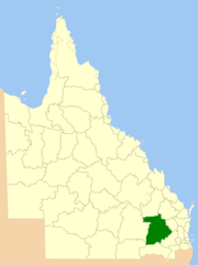
Western Downs Region
| Western Downs Region Queensland | |||||||||||||||
|---|---|---|---|---|---|---|---|---|---|---|---|---|---|---|---|
 Location within Queensland | |||||||||||||||
| Population | 33,799 (2015)[1] | ||||||||||||||
| • Density | 0.888535/km2 (2.30130/sq mi) | ||||||||||||||
| Established | 2008 | ||||||||||||||
| Area | 38,039 km2 (14,686.9 sq mi) | ||||||||||||||
| Mayor | Paul McVeigh | ||||||||||||||
| Council seat | Dalby | ||||||||||||||
| State electorate(s) | |||||||||||||||
| Federal Division(s) | Maranoa | ||||||||||||||
 | |||||||||||||||
| Website | Western Downs Region | ||||||||||||||
| |||||||||||||||
Western Downs Region is a local government area in Queensland, Australia. The Western Downs Regional Council manages an area of 38,039 square kilometres (14,687 sq mi), which is approximately the same size as the country of Switzerland, although with a population at the last census of close to 33,000, it is over 235 times less densely populated.
The area is home to prime farming land and thus agriculture is a major industry in the area. Dalby, the biggest town in the region is home to the second largest cattle saleyards in Australia. The Dalby Saleyards process over 200,000 cattle annually in its state of the art facility which is comparable to Rockhampton and Casino.
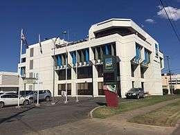
The Western Downs Regional Council's Corporate Office is situated at 30 Marble Street, Dalby.
History
Western Downs Region was created in March 2008 as a result of the report of the Local Government Reform Commission released in July 2007.
Prior to the 2008 amalgamation, the new Region, located in the Darling Downs region, consisted the entire area of five previous local government areas:
- the Town of Dalby;
- the Shire of Chinchilla;
- the Shire of Murilla;
- the Shire of Tara;
- the Shire of Wambo;
- and Division 2 of the Shire of Taroom.
The report recommended that the new local government area should not be divided into wards and elect ten councillors and a mayor. The report estimated that the resident population in 2006 was 30,018 and the operating budget was A$74 million.
Originally called Dalby Region, a name change to Western Downs was approved in August 2009.[2] The name change was greeted positively by residents as they felt the name was more inclusive and a better representation of the area. The name "Western Downs" stems from the phrase Darling Downs, and as the name suggests; the area to the west of the downs.
Towns and localities
The Western Downs Region includes the following settlements:
|
Dalby area:
Chichilla area:
Murilla area:
|
Tara area:
Wambo area:
South Taroom area:
|
1 - shared with the Shire of Banana
Libraries
The Western Downs Regional Council operates public libraries at Bell, Chinchilla, Dalby, Jandowae, Meandarra, Miles, Moonie, Tara, and Wandoan.[3]
Population
| Town | Population | Location |
|---|---|---|
| Bell | 544 | 39 km NE of Dalby |
| Brigalow | 404 | 62 km NW of Dalby, 20 km SE of Chinchilla |
| Chinchilla | 5,487 | 82 km NW of Dalby |
| Condamine | 426 | 125 km W of Dalby, 59 km SW of Chinchilla |
| Dalby | 12,299 | 210 km WNW of Brisbane, 82 km SE of Dalby |
| Drillham | 217 | 148 WNW of Dalby, 66 km W of Chinchilla |
| Dulacca | 249 | 170 km WNW of Dalby, 89 km W of Chinchilla |
| Glenmorgan | 385 | 173 km W of Dalby, 138 km SW of Chinchilla |
| Jandowae | 1,246 | 49 km NNW of Dalby, 56 km E of Chinchilla |
| Jimbour | 185 | 26 km N of Dalby, 73 km ESE of Chinchilla |
| Kaimkillenbun | 566 | 24 km NE of Dalby |
| Kogan | 355 | 53 km WNW of Dalby, 46 km SE of Chinchilla |
| Miles | 1854 | 127 km WNW of Dalby, 46 km W of Chinchilla |
| Moonie | 253 | 114 km SW of Dalby, 144 km S of Chinchilla |
| Tara | 2,211 | 89 km W of Dalby, 70 km S of Chinchilla |
| The Gums | 170 | 117 km WSW of Dalby, 96 km SSW of Chinchilla |
| Wandoan | 665 | 196 km NW of Dalby, 115 km NW of Chinchilla |
| Warra | 318 | 46 km NW of Dalby, 36 km SE of Chinchilla |
- * - shared with the Shire of Banana
Region Representatives
Mayors
Councillors
The councillors electored in 2016 were:[8]
- Andrew Smith* (2008–Present)
- Carolyn Tillman* (2008–Present)
- Greg Olm (2012–Present)
- Ian Rasmussen (2012–Present)
- Peter Saxelby (2016-Present)
- Kaye Maguire (2016-Present)
- Donna Ashurst (2016-Present)
*was representative of a region pre-amalgamation
References
- ↑ "3218.0 – Regional Population Growth, Australia, 2014–15". Australian Bureau of Statistics. Retrieved 29 September 2016.
- ↑ "Council set to launch new identity". Western Downs Regional Council. 5 August 2009. Archived from the original on 2 October 2009. Retrieved 21 January 2014.
- ↑ "Branch Libraries". Western Downs Regional Council. Archived from the original on 31 January 2018. Retrieved 31 January 2018.
- ↑ "2008 Dalby Regional Council - Mayoral Election - Election Summary". Electoral Commission of Queensland. Retrieved 2 March 2015.
- ↑ "2012 Western Downs Regional Council - Mayoral Election - Election Summary". Electoral Commission of Queensland. Retrieved 2 March 2015.
- ↑ "Councillor Profiles". Western Downs Regional Council. Retrieved 21 January 2014.
- ↑ "Councillors Profiles". Western Downs Regional Council. Retrieved 8 April 2016.
- ↑ "2016 Western Downs Regional Council - Councillor Election - Election Summary". Electoral Commission of Queensland. 20 April 2016. Retrieved 1 November 2016.
External links
![]()
Coordinates: 27°11′3″S 151°15′52″E / 27.18417°S 151.26444°E