Shire of Wambo
| Shire of Wambo Queensland | |||||||||||||||
|---|---|---|---|---|---|---|---|---|---|---|---|---|---|---|---|
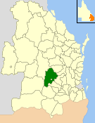 Location within Queensland | |||||||||||||||
| Population | 5,229 (2006 census)[1] | ||||||||||||||
| • Density | 0.91581/km2 (2.37194/sq mi) | ||||||||||||||
| Established | 1879 | ||||||||||||||
| Area | 5,709.7 km2 (2,204.5 sq mi) | ||||||||||||||
| Council seat | Dalby | ||||||||||||||
| Region | Darling Downs | ||||||||||||||
|
| |||||||||||||||
| Website | Shire of Wambo | ||||||||||||||
| |||||||||||||||
The Shire of Wambo was a local government area in the Darling Downs region of Queensland, Australia. The shire completely surrounded but did not include the town of Dalby — which had its own municipal government. It covered an area of 5,709.7 square kilometres (2,204.5 sq mi), and existed as a local government entity from 1879 until 2008, when it amalgamated with the Town of Dalby and the Shires of Chinchilla, Murilla and Tara and the southern part of Taroom to form the Western Downs Region.
History
Wambo Division was created on 11 November 1879 as one of 74 divisions around Queensland under the Divisional Boards Act 1879 with a population of 1018.[2][3]
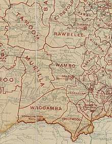
On 23 February 1882, there was a realignment of boundaries between Wambo Division and Barambah Division, involving subdivision 3 of Wambo Division and subdivisions 1 and 2 of Barambah Division.[4][5]
With the passage of the Local Authorities Act 1902, Wambo Division became the Shire of Wambo on 31 March 1903.[3][6]
On 15 March 2008, under the Local Government (Reform Implementation) Act 2007 passed by the Parliament of Queensland on 10 August 2007, the Shire of Wambo merged with the Town of Dalby and the Shires of Chinchilla, Murilla and Tara and Division 2 of the Shire of Taroom (the Wandoan area) to form the Western Downs Region.[6][7]
Towns and localities
The Shire of Wambo included the following settlements:
|
Towns:
|
Localities:
|
Chairmen
- 1927: Richard Henry Francis Best junior [8]
Population
| Year | Population |
|---|---|
| 1921 | 4,908 |
| 1933 | 5,208 |
| 1947 | 6,046 |
| 1954 | 6,976 |
| 1961 | 6,893 |
| 1966 | 6,452 |
| 1971 | 5,659 |
| 1976 | 5,423 |
| 1981 | 5,511 |
| 1986 | 5,497 |
| 1991 | 5,184 |
| 1996 | 5,205 |
| 2001 | 5,102 |
| 2006 | 5,229 |
References
- ↑ Australian Bureau of Statistics (25 October 2007). "Wambo (S) (Local Government Area)". 2006 Census QuickStats. Retrieved 15 June 2011.
- ↑ "Proclamation [Wambo Division]". Queensland Government Gazette. 11 November 1879. p. 25:997.
- 1 2 "Agency ID11214, Wambo Divisional Board". Queensland State Archives. Retrieved 21 September 2013.
- ↑ "Proclamation [Wambo Division amendment]". Queensland Government Gazette. 25 February 1882. p. 30:426-427.
- ↑ "Proclamation [Barambah Division amendment]". Queensland Government Gazette. 25 February 1882. p. 30:427-428.
- 1 2 "Agency ID1929, Wambo Shire Council". Queensland State Archives. Retrieved 21 September 2013.
- ↑ "Agency ID11044, Western Downs Regional Council". Queensland State Archives. Retrieved 21 September 2013.
- ↑ Pugh, Theophilus Parsons (1927). Pugh's Almanac for 1927. Retrieved 13 June 2014.
External links
- "Wanbo Shire". Queensland Places. Centre for the Government of Queensland, University of Queensland.
Coordinates: 27°11′00″S 151°15′43″E / 27.18333°S 151.26194°E