The Gums, Queensland
| The Gums Queensland | |||||||||||||||
|---|---|---|---|---|---|---|---|---|---|---|---|---|---|---|---|
 The Gums | |||||||||||||||
| Coordinates | 27°20′25″S 150°12′18″E / 27.3402°S 150.205°ECoordinates: 27°20′25″S 150°12′18″E / 27.3402°S 150.205°E | ||||||||||||||
| Population | 169 (2006 census)[1] | ||||||||||||||
| • Density | 0.1380/km2 (0.3573/sq mi) | ||||||||||||||
| Postcode(s) | 4406 | ||||||||||||||
| Area | 1,225.0 km2 (473.0 sq mi) | ||||||||||||||
| Location | |||||||||||||||
| LGA(s) | Western Downs Region | ||||||||||||||
| State electorate(s) | Warrego | ||||||||||||||
| Federal Division(s) | Maranoa | ||||||||||||||
| |||||||||||||||
The Gums is a town and locality in the Western Downs Region, Queensland, Australia.[2][3] At the 2006 census, The Gums and the surrounding area had a population of 169.[1]
Geography
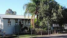
The town is at the junction of the Leichhardt Highway and the Surat Developmental Road[4] on the Darling Downs, 329 kilometres (204 mi) west of the state capital, Brisbane.
The Western railway line passes through the locality with three stations serving the locality, The Gums railway station,[5] Cabawin railway station,[6] and South Glen railway station.[7]
History
The name of the town was derived from The Gums railway station, on the Western railway line from Dalby to Glenmorgan,[8] used from 1924.[2][5]
The Gums State School opened on 27 January 1913.[9]
Education
The Gums State School is a government co-educational primary (P-6) school at 12051 Coomrith Road. In 2016, the school had an enrolment of 27 students with 4 teachers (3 full-time equivalent) with 5 non-teaching staff (2 full-time equivalent).[10]
Facilities
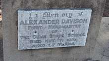
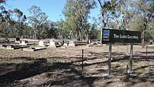
The Gums has a small cemetery. One of the headstones is for the first headmaster of The Gums State School, Alexander Davison who died on 7 November 1916.
References
- 1 2 Australian Bureau of Statistics (25 October 2007). "The Gums (Tara Shire) (State Suburb)". 2006 Census QuickStats. Retrieved 2008-11-04.
- 1 2 "The Gums - town (entry 33961)". Queensland Place Names. Queensland Government. Retrieved 23 June 2017.
- ↑ "The Gums - locality (entry 47751)". Queensland Place Names. Queensland Government. Retrieved 23 June 2017.
- ↑ "The Gums". australianexplorer.com. Retrieved 15 October 2010.
- 1 2 "The Gums - railway station in the Western Down Region (entry 33962)". Queensland Place Names. Queensland Government. Retrieved 25 December 2017.
- ↑ "Cabawin - railway station in the Western Downs Region (entry 5606)". Queensland Place Names. Queensland Government. Retrieved 26 December 2017.
- ↑ "South Glen - railway station in the Western Downs Region (entry 31458)". Queensland Place Names. Queensland Government. Retrieved 25 December 2017.
- ↑ "Location Profiles - Darling Downs-West Moreton Health Service District - GLENMORGAN". Queensland Government. 23 February 2010. Retrieved 17 October 2010.
- ↑ Queensland Family History Society (2010), Queensland schools past and present (Version 1.01 ed.), Queensland Family History Society, ISBN 978-1-921171-26-0
- ↑ "Annual Report 2016" (PDF). The Gums State School. Archived (PDF) from the original on 19 September 2017. Retrieved 19 September 2017.
External links
![]()