Shire of Murilla
| Shire of Murilla Queensland | |||||||||||||||
|---|---|---|---|---|---|---|---|---|---|---|---|---|---|---|---|
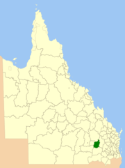 Location within Queensland | |||||||||||||||
| Population | 2,687 (2006 census)[1] | ||||||||||||||
| • Density | 0.44225/km2 (1.14541/sq mi) | ||||||||||||||
| Established | 1879 | ||||||||||||||
| Area | 6,075.8 km2 (2,345.9 sq mi) | ||||||||||||||
| Council seat | Miles | ||||||||||||||
| Region | Darling Downs | ||||||||||||||
|
| |||||||||||||||
| Website | Shire of Murilla | ||||||||||||||
| |||||||||||||||
The Shire of Murilla was a local government area located in the Darling Downs region of Queensland, Australia. The shire, administered from the town of Miles, covered an area of 6,075.8 square kilometres (2,345.9 sq mi), and existed as a local government entity from 1879 until 2008, when it amalgamated with the Town of Dalby and the Shires of Chinchilla, Tara and Wambo and the southern part of Taroom to form the Western Downs Region.
History
Murilla Division was created on 11 November 1879 as one of 74 divisions around Queensland under the Divisional Boards Act 1879 with a population of 761.[2][3]
With the passage of the Local Authorities Act 1902, Murilla Division became the Shire of Murilla on 31 March 1903.[3][4]
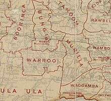
On 15 March 2008, under the Local Government (Reform Implementation) Act 2007 passed by the Parliament of Queensland on 10 August 2007, the Shire of Murilla merged with the Town of Dalby and the Shires of Chinchilla, Tara and Wambo and Division 2 of Shire of Taroom (the Wandoan area) to form the Western Downs Region.[4][5]
Towns and localities
The Shire of Murilla included the following settlements:
|
Towns:
|
Localities:
|
Population
| Year | Population |
|---|---|
| 1933 | 2,217 |
| 1947 | 2,493 |
| 1954 | 3,090 |
| 1961 | 3,599 |
| 1966 | 3,494 |
| 1971 | 3,239 |
| 1976 | 3,137 |
| 1981 | 3,007 |
| 1986 | 3,212 |
| 1991 | 2,919 |
| 1996 | 2,775 |
| 2001 | 2,687 |
| 2006 | 2,740 |
Chairmen
References
- ↑ Australian Bureau of Statistics (25 October 2007). "Murilla (S) (Local Government Area)". 2006 Census QuickStats. Retrieved 15 June 2011.
- ↑ "Proclamation [Murilla Division]". Queensland Government Gazette. 11 November 1879. p. 25:998.
- 1 2 "Agency ID11021, Murilla Divisional Board". Queensland State Archives. Retrieved 21 September 2013.
- 1 2 "Agency ID10975, Murilla Shire Council". Queensland State Archives. Retrieved 21 September 2013.
- ↑ "Agency ID11044, Western Downs Regional Council". Queensland State Archives. Retrieved 21 September 2013.
- 1 2 Consolidated Index to Queensland Government Gazette 1859-1919. Queensland Family History Society. 2004. ISBN 1 876613 79 3.
- ↑ Pugh, Theophilus Parsons (1927). Pugh's Almanac for 1927. Retrieved 13 June 2014.
External links
Coordinates: 26°39′27.25″S 150°11′03.54″E / 26.6575694°S 150.1843167°E