Watlington, Norfolk
.jpg)
| Watlington | |
|---|---|
 Watlington Watlington shown within Norfolk | |
| Area | 6.93 km2 (2.68 sq mi) |
| Population | 2,455 (2011 Census) |
| • Density | 354/km2 (920/sq mi) |
| OS grid reference | TF619111 |
| Civil parish |
|
| District | |
| Shire county | |
| Region | |
| Country | England |
| Sovereign state | United Kingdom |
| Post town | KING'S LYNN |
| Postcode district | PE33 |
| Police | Norfolk |
| Fire | Norfolk |
| Ambulance | East of England |
| EU Parliament | East of England |
Watlington is a civil parish and electoral ward in the English county of Norfolk. It covers an area of 6.93 km2 (2.68 sq mi) and had a population of 2,031 in 852 households at the 2001 census,[1] the population increasing to 2,455 at the 2011 Census.[2] For the purposes of local government, it falls within the district of King's Lynn and West Norfolk.
It is situated some 2 km (1.2 mi) from the east bank of the River Great Ouse, 12 km (7.5 mi) south of the town of King's Lynn and 60 km (37 mi) west of the city of Norwich.[3]
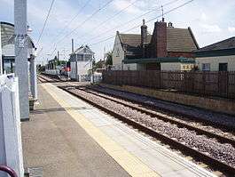
The village is served by Watlington railway station (on the Fen Line between Cambridge and King's Lynn) which is situated 1 km (0.62 mi) from the centre of the village.
The village should not be confused with the town of Watlington in Oxfordshire.
Notes
- ↑ Census population and household counts for unparished urban areas and all parishes Archived 2017-02-11 at the Wayback Machine.. Office for National Statistics & Norfolk County Council (2001). Retrieved 20 June 2009.
- ↑ "Parish/Ward population 2011". Retrieved 30 August 2015.
- ↑ Ordnance Survey (1999). OS Explorer Map 236 - King's Lynn, Downham Market & Swaffham. ISBN 0-319-21867-8.
References
- ^ Office for National Statistics & Norfolk County Council (2001). Census population and household counts for unparished urban areas and all parishes. Retrieved December 2, 2005.
Gallery
 Watlington in 2005.
External links
| Wikimedia Commons has media related to Watlington, Norfolk. |
- Map sources for Watlington, Norfolk.
- Information from Genuki Norfolk on Watlington.