Feltwell
| Feltwell | |
|---|---|
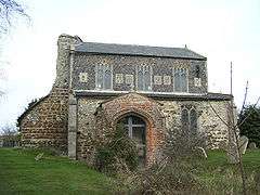 The truncated St Nicholas's Church, Feltwell (now redundant) | |
 Feltwell Feltwell shown within Norfolk | |
| Area | 52.16 km2 (20.14 sq mi) |
| Population | 2,825 (2001 census and 2011 Census[1]) |
| • Density | 54/km2 (140/sq mi) |
| OS grid reference | TL711905 |
| District | |
| Shire county | |
| Region | |
| Country | England |
| Sovereign state | United Kingdom |
| Post town | Thetford |
| Postcode district | IP26 |
| Dialling code | 01842 |
| Police | Norfolk |
| Fire | Norfolk |
| Ambulance | East of England |
| EU Parliament | East of England |
| UK Parliament | |
Feltwell is a village 10 miles west of Thetford, Norfolk, England, and is in the borough of King's Lynn and West Norfolk.
Landmarks and facilities
Feltwell has the largest area of any parish in Norfolk. It is a thriving community. The village has a large modern primary school which was originally built during the post WW2 building period to cope with the 1946-48 "baby-boom". The original school buildings are of late Victorian era mock perpendicular flint-faced single-storey buildings, which catered for all age groups on either side of Long Beck Road.
Because of its size it is well provided with amenities. In addition to a general practice surgery and attached pharmacy there are a vet's surgery, a garage / service station, two convenience stores, a hairdressers, a card and gift store, a Chinese takeaway, a traditional fish & chip shop, a gymnasium, a secondhand goods yard and a number of small businesses clustered in what used to be a snooker hall. Of late there have been up to three pubs in the village but the uncertainties of the licensed trade today mean that each has had periods of being 'dark' The pubs as of early 2018 are The Wellington (a relaunch of The Lodge paying homage to the Wellington bombers that flew from Feltwell in WW2) and Amy's Diner, previously The West End. There is also a Social Club. The Chequers is currently closed.
The village also has two churches, St Mary's and St Nicholas's (pictured above) which is now redundant, together with a Methodist chapel. The street known as Long Beck as against Short Beck obtained its name from the stream (depicted on OS maps as the common bank dyke) which was spring-fed from a pond in the southeast corner of the new primary school site. Feltwell was virtually a sea-shore settlement during the Roman occupation: when the New Cut relief channel was excavated several Roman villas were discovered along the excavation route of the river, and were injudiciously destroyed.
The village was the site of a busy RAF bomber command aerodrome in WW2[2] that now houses US schooling, furniture storage and some satellite tracking from three large aerials housed in distinctive balls. Other neighbouring RAF fields now used by USAFE are RAF Lakenheath and RAF Mildenhall.
John Gower connection
In August 1382 John Gower purchased the manors of Feltwell in Norfolk and Moulton in Suffolk. They were then granted to Thomas Blakelake, parson of St Nicholas's, Feltwell, and others, at a rent of forty pounds annually for his life.[3]:xvi
See also
References
- ↑ Census population and household counts for unparished urban areas and all parishes. Office for National Statistics & Norfolk County Council (2001). Retrieved 20 June 2009.
- ↑ Bowyer, Michael (1979). Action Stations Vol 1. PSL. pp. 111–114. ISBN 0 85059 335 2.
- ↑ G.C. Macaulay (ed.). "Introduction, Life of Gower". The Complete Works of John Gower, Vol 4 The Latin Works (PDF). p. vii-xxx.
External links
![]()