Wiggenhall St Germans
Wiggenhall St Germans
| |
|---|---|
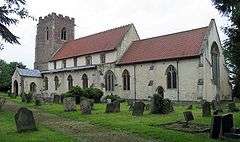 St Mary the Virgin's Church, Wiggenhall | |
 Wiggenhall St Germans Wiggenhall St Germans shown within Norfolk | |
| Area | 18.98 km2 (7.33 sq mi) |
| Population | 1,373 (2011) |
| • Density | 72/km2 (190/sq mi) |
| OS grid reference | TF596141 |
| • London | 136 km (85 mi) WbS |
| Civil parish |
|
| District | |
| Shire county | |
| Region | |
| Country | England |
| Sovereign state | United Kingdom |
| Post town | King's Lynn |
| Postcode district | PE34 |
| Dialling code | 01553 |
| Police | Norfolk |
| Fire | Norfolk |
| Ambulance | East of England |
| EU Parliament | East of England |
| UK Parliament | |
| Website | Wiggenhall St Germans Parish Council |
Wiggenhall St Germans is a civil parish in the English county of Norfolk in the East of England. It is 85 miles (137 km) north of London and 5 miles (8.0 km) south-west of King's Lynn. The parish covers an area of 18.98 km2 (7.33 sq mi) and had a population of 1,373 in 554 households in the 2011 census.[1]
The parish is situated on the River Great Ouse which divides the village into two parts. Most of the parish lies below the high-water mark and some areas are level with the bed of the river, which is confined by high banks.[2]
The parish includes the hamlets of Wiggenhall St Mary the Virgin and Wiggenhall St Peter and the settlements of Eau Brink[3][4] and Saddlebow[5] It was the site of Fitton, the ancient seat of the Howard family, later the dukes of Norfolk,[2] with their former hall now known as the listed building Fitton Oake.[6] St Mary the Virgin's Church is under the care of the Churches Conservation Trust.[7]
Governance
Wiggenhall St Germans is part of the electoral ward called Wiggenhall. The population of this ward at the 2011 Census was 2,102.[8]
References
- ↑ Office for National Statistics (2011). "Neighbourhood Statistics — Wiggenhall St Germans". Retrieved 29 May 2013.
- 1 2 Samuel Lewis, ed. (1848). "Wiggenhall-Wigton". A Topographical Dictionary of England. British History Online. Retrieved 7 June 2013.
- ↑ "Google Streetview of A47 showing Eau Brink name sign".
- ↑ "Google Streetview showing Eau Brink name sign in Wiggenhall St Germans".
- ↑ ."Google Streetview showing Saddlebow village entry highway name sign".
- ↑ "Fitton Oake, Wiggenhall St Germans, Norfolk".
- ↑ Church of St Mary the Virgin, Wiggenhall, Norfolk, Churches Conservation Trust, retrieved 3 December 2016 . It has a Good Ofsted rated Primary School, (March 2016).
- ↑ "Wiggenhall Ward population 2011". Retrieved 30 August 2015.
External links
![]()