Wereham
| Wereham | |
|---|---|
 Wereham Wereham shown within Norfolk | |
| Area | 8.59 km2 (3.32 sq mi) |
| Population | 660 (2011 census)[1] |
| • Density | 77/km2 (200/sq mi) |
| OS grid reference | TF680016 |
| District | |
| Shire county | |
| Region | |
| Country | England |
| Sovereign state | United Kingdom |
| Post town | KING'S LYNN |
| Postcode district | PE33 |
| Dialling code | 01366 |
| Police | Norfolk |
| Fire | Norfolk |
| Ambulance | East of England |
| EU Parliament | East of England |
| UK Parliament | |
Wereham is a small village and civil parish in the English county of Norfolk.
Location
Wereham lies in the Wissey valley and is on the main A134 road; it is some five miles to the east of the town of Downham Market and thirteen miles from King's Lynn. Neighbouring villages include Boughton, Fincham, Crimplesham, West Dereham, Wretton and Stoke Ferry.
History
In the centre of the village is the pond - known locally as the pit. Nearby on the village green, the Village sign depicts 'Billy the Seal', one of Wereham's most famous residents from the 1920s.
Facilities
Wereham once had four pubs: the George and Dragon, The Crown, The Nags Head and The Chequers; however, only the George and Dragon remains. The village also had a school; this closed in the 1980s.
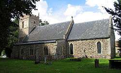
The Parish Church, dedicated to St Margaret of Antioch, is in the centre of the village.
2018 will see the completion of the 1st UK Passivhaus Village Hall. Passivhaus buildings provide a high level of occupant comfort while using very little energy for heating and cooling. http://werehamvillagehall.co.uk/index.php/what-s-on/77-from-the-news/110-new-community-hub-2
References
- ↑ "Parish population 2011". Retrieved 30 August 2015.
External links
| Wikimedia Commons has media related to Wereham. |
- GENUKI page
- The Wereham Category of the Group 4 News Website.
- The Wereham Category of the Stoke Ferry Website includes Parish Council meeting minutes.