Wertsville, New Jersey
| Wertsville, New Jersey | |
|---|---|
| Unincorporated community | |
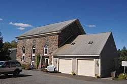 The old Wertsville Baptist Church | |
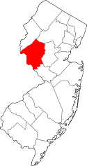
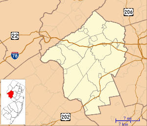 Wertsville, New Jersey Location of Wertsville in Hunterdon County Inset: Location of county within the state of New Jersey  Wertsville, New Jersey Wertsville, New Jersey (New Jersey)  Wertsville, New Jersey Wertsville, New Jersey (the US) | |
| Coordinates: 40°26′59″N 74°47′52″W / 40.44972°N 74.79778°WCoordinates: 40°26′59″N 74°47′52″W / 40.44972°N 74.79778°W | |
| Country |
|
| State |
|
| County | Hunterdon |
| Township | East Amwell |
| Named for | Werts family |
| Elevation[1] | 154 ft (47 m) |
| GNIS feature ID | 881666[1] |
|
Wertsville Historic District | |
| Coordinates | 40°26′54″N 74°47′46″W / 40.44833°N 74.79611°W |
|---|---|
| NRHP reference # | 00001150[2] |
| Added to NRHP | October 5, 2000 |
Wertsville is an unincorporated community located within East Amwell Township in Hunterdon County, New Jersey, United States.[3]
History
The settlement is named for the Werts family, and was known locally as "Werts' Corners".
By 1881, Wertsville had a school, Baptist church, post office, store, shoemaker shop and wagon shop.[4]
References
- 1 2 "Wertsville". Geographic Names Information System. United States Geological Survey.
- ↑ National Park Service (2010-07-09). "National Register Information System". National Register of Historic Places. National Park Service.
- ↑ Locality Search, State of New Jersey. Accessed February 7, 2015.
- ↑ Snell, James P. (1881). History of Hunterdon and Somerset Counties, New Jersey. Everts & Peck. p. 356.
| Topics | 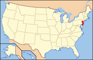 | ||
|---|---|---|---|
| Lists by county | |||
| Lists by city |
| ||
| Other lists | |||
| |||
This article is issued from
Wikipedia.
The text is licensed under Creative Commons - Attribution - Sharealike.
Additional terms may apply for the media files.