Allerton, New Jersey
| Allerton, New Jersey | |
|---|---|
| Unincorporated community | |
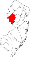
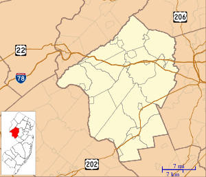 Allerton, New Jersey Allerton's location in Hunterdon County (Inset: Hunterdon County in New Jersey)  Allerton, New Jersey Allerton, New Jersey (New Jersey)  Allerton, New Jersey Allerton, New Jersey (the US) | |
| Coordinates: 40°36′40″N 74°52′43″W / 40.61111°N 74.87861°WCoordinates: 40°36′40″N 74°52′43″W / 40.61111°N 74.87861°W | |
| Country |
|
| State |
|
| County | Hunterdon |
| Township | Clinton |
| Elevation[1] | 74 m (243 ft) |
| Time zone | UTC-5 (Eastern (EST)) |
| • Summer (DST) | UTC-4 (EDT) |
| GNIS feature ID | 874303[1] |
Allerton (also known as Allerville) is an unincorporated community located within Clinton Township, in Hunterdon County, New Jersey, United States.[1][2][3]
The community is centered at Route 31 and Allerton Road, 1.8 miles (2.9 km) west of the Round Valley Reservoir and 3.3 miles (5.3 km) southeast of the Spruce Run Reservoir.[4]
By 1846, Allerton had a store, steam saw mill, Baptist church, chair factory, and a few dwellings.[5]
References
- 1 2 3 Feature Detail Report for: Allerton, Geographic Names Information System. Accessed January 1, 2015.
- ↑ Locality Search, State of New Jersey. Accessed January 1, 2015.
- ↑ Areas covering the point (-74.878611,40.611111), MapIt. Accessed January 2, 2015.
- ↑ N 40.61111 W 74.87861, ACME Mapper. Accessed January 2, 2015.
- ↑ Barber, John Warner; Howe, Henry (1846). Historical Collections of the State of New Jersey: Containing a General Collection of the Most Interesting Facts, Traditions, Biographical Sketches, Anecdotes, Etc. Relating to Its History and Antiquities, with Geographical Descriptions of Every Township in the State. S. Tuttle. p. 249.
This article is issued from
Wikipedia.
The text is licensed under Creative Commons - Attribution - Sharealike.
Additional terms may apply for the media files.