McCrea Mills, New Jersey
| McCrea Mills, New Jersey | |
|---|---|
| Unincorporated community | |
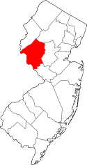
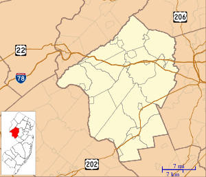 McCrea Mills, New Jersey Location of McCrea Mills in Hunterdon County Inset: Location of county within the state of New Jersey  McCrea Mills, New Jersey McCrea Mills, New Jersey (New Jersey)  McCrea Mills, New Jersey McCrea Mills, New Jersey (the US) | |
| Coordinates: 40°39′42″N 74°45′59″W / 40.66167°N 74.76639°WCoordinates: 40°39′42″N 74°45′59″W / 40.66167°N 74.76639°W | |
| Country |
|
| State |
|
| County | Hunterdon |
| Township | Readington |
| Elevation[1] | 174 ft (53 m) |
| GNIS feature ID | 878213[1] |
McCrea Mills is an unincorporated community located within Readington Township in Hunterdon County, New Jersey, United States.[2]
References
- 1 2 "McCrea Mills". Geographic Names Information System. United States Geological Survey.
- ↑ Google (January 31, 2015). "McCrea Mills, Readington Township, New Jersey" (Map). Google Maps. Google. Retrieved January 31, 2015.
This article is issued from
Wikipedia.
The text is licensed under Creative Commons - Attribution - Sharealike.
Additional terms may apply for the media files.